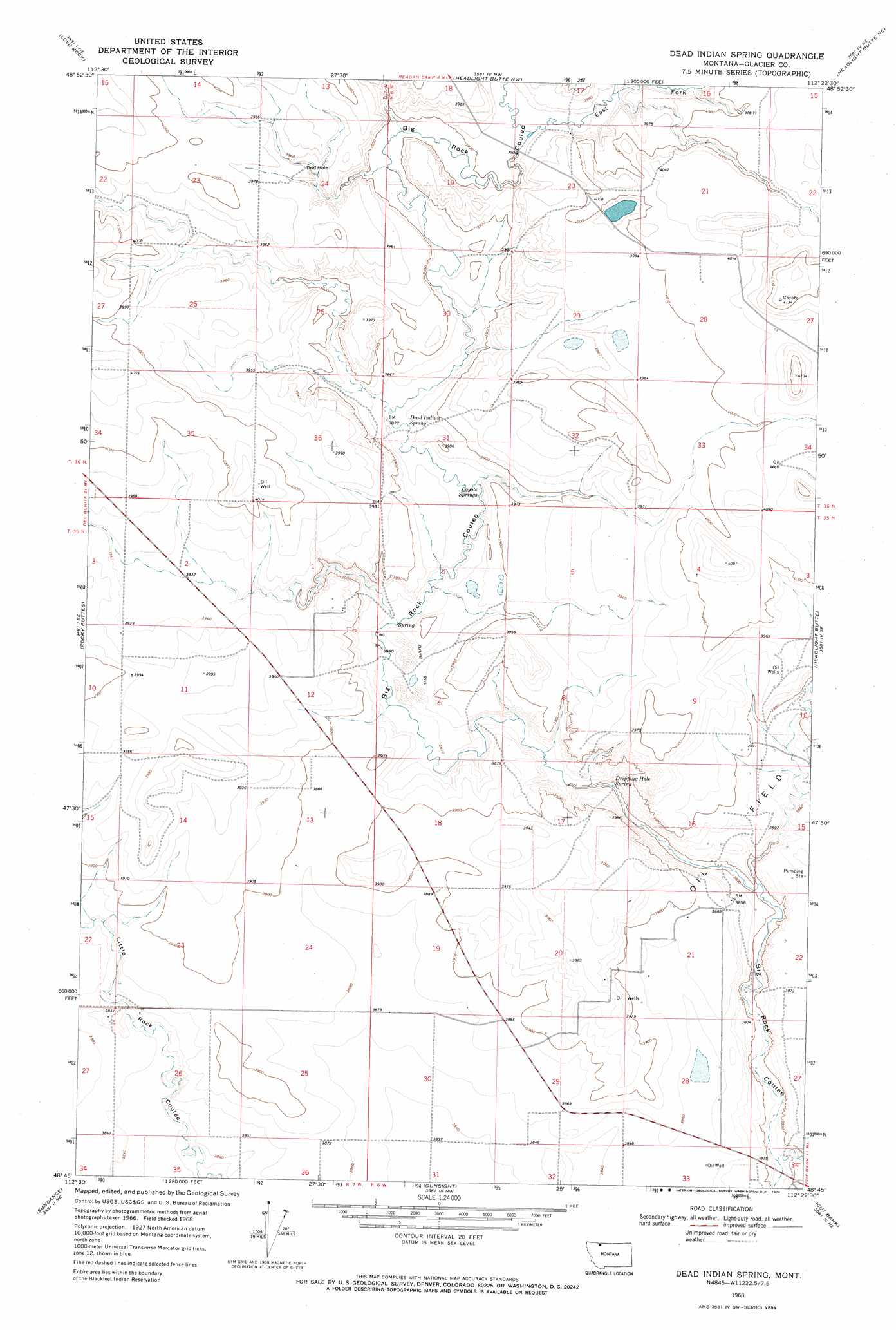
Dead Indian Spring Topo Map Montana
To zoom in, hover over the map of Dead Indian Spring
USGS Topo Quad 48112g4 - 1:24,000 scale
| Topo Map Name: | Dead Indian Spring |
| USGS Topo Quad ID: | 48112g4 |
| Print Size: | ca. 21 1/4" wide x 27" high |
| Southeast Coordinates: | 48.75° N latitude / 112.375° W longitude |
| Map Center Coordinates: | 48.8125° N latitude / 112.4375° W longitude |
| U.S. State: | MT |
| Filename: | o48112g4.jpg |
| Download Map JPG Image: | Dead Indian Spring topo map 1:24,000 scale |
| Map Type: | Topographic |
| Topo Series: | 7.5´ |
| Map Scale: | 1:24,000 |
| Source of Map Images: | United States Geological Survey (USGS) |
| Alternate Map Versions: |
Dead Indian Spring MT 1968, updated 1972 Download PDF Buy paper map Dead Indian Spring MT 2011 Download PDF Buy paper map Dead Indian Spring MT 2014 Download PDF Buy paper map |
1:24,000 Topo Quads surrounding Dead Indian Spring
Landslide Butte |
Love Rock |
Headlight Butte Nw |
Headlight Butte Ne |
Fitzpatrick Lake |
Buffalo Lake |
Rocky Buttes |
Dead Indian Spring |
Headlight Butte |
Glacier Colony |
Fort Piegan |
Sundance |
Gunsight |
Cut Bank |
Ethridge Nw |
Mission Lake West |
Mission Lake East |
Squaw Buttes |
Cut Bank Se |
Boru Spring |
> Back to 48112e1 at 1:100,000 scale
> Back to 48112a1 at 1:250,000 scale
> Back to U.S. Topo Maps home
Dead Indian Spring topo map: Gazetteer
Dead Indian Spring: Springs
Coyote Springs elevation 1174m 3851′Dead Indian Spring elevation 1177m 3861′
Dripping Hole Spring elevation 1159m 3802′
Dead Indian Spring: Valleys
East Fork Big Rock Coulee elevation 1191m 3907′Dead Indian Spring: Wells
35N06W10BC__01 Well elevation 1205m 3953′35N06W15BD__01 Well elevation 1181m 3874′
35N06W21AB__01 Well elevation 1188m 3897′
35N06W21BC__01 Well elevation 1186m 3891′
35N06W21CB__01 Well elevation 1184m 3884′
Dead Indian Spring digital topo map on disk
Buy this Dead Indian Spring topo map showing relief, roads, GPS coordinates and other geographical features, as a high-resolution digital map file on DVD: