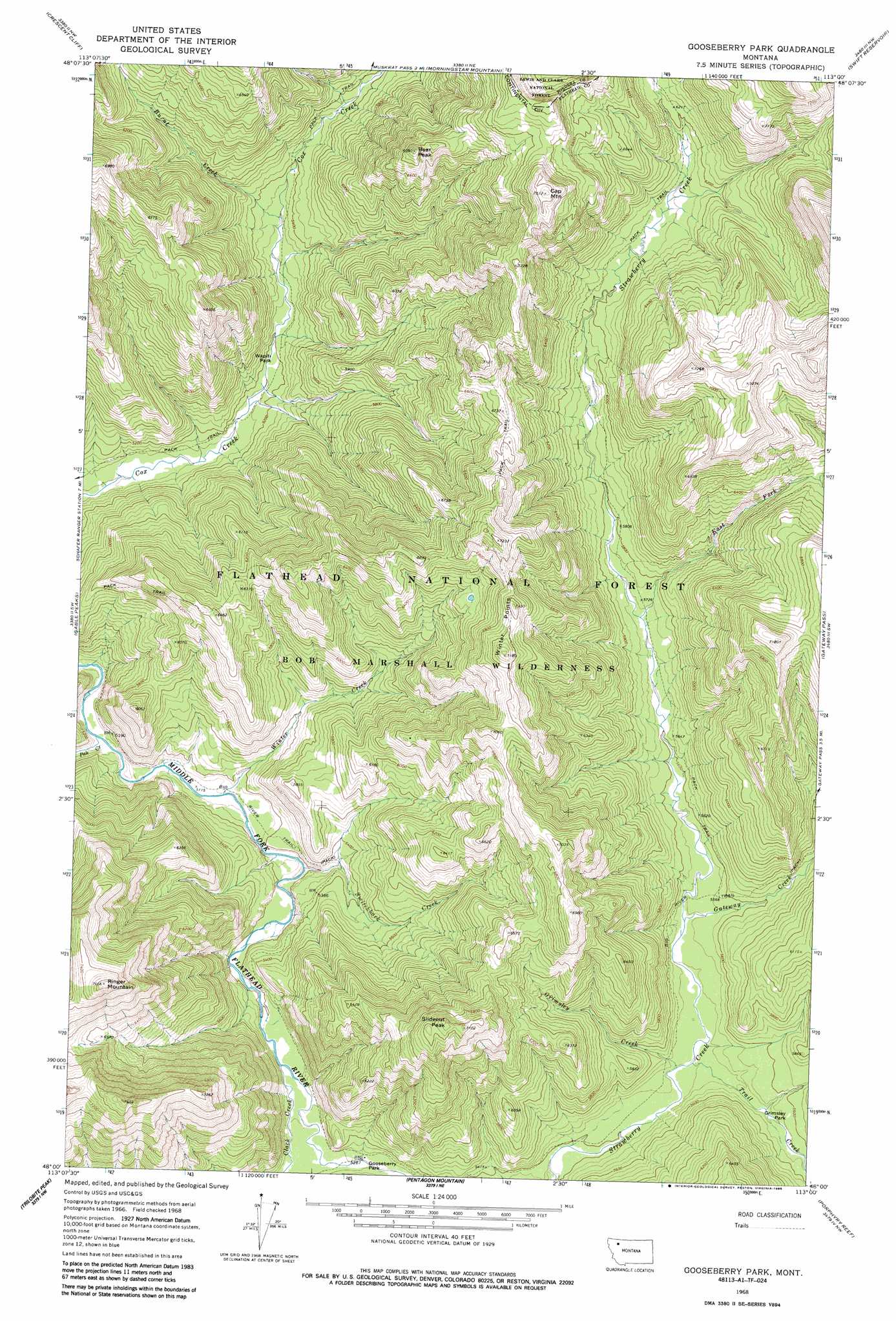
Gooseberry Peak Topo Map Montana
To zoom in, hover over the map of Gooseberry Peak
USGS Topo Quad 48113a1 - 1:24,000 scale
| Topo Map Name: | Gooseberry Peak |
| USGS Topo Quad ID: | 48113a1 |
| Print Size: | ca. 21 1/4" wide x 27" high |
| Southeast Coordinates: | 48° N latitude / 113° W longitude |
| Map Center Coordinates: | 48.0625° N latitude / 113.0625° W longitude |
| U.S. State: | MT |
| Filename: | o48113a1.jpg |
| Download Map JPG Image: | Gooseberry Peak topo map 1:24,000 scale |
| Map Type: | Topographic |
| Topo Series: | 7.5´ |
| Map Scale: | 1:24,000 |
| Source of Map Images: | United States Geological Survey (USGS) |
| Alternate Map Versions: |
Gooseberry Park MT 1968, updated 1972 Download PDF Buy paper map Gooseberry Park MT 1968, updated 1986 Download PDF Buy paper map Gooseberry Park MT 1994, updated 1997 Download PDF Buy paper map Gooseberry Park MT 2011 Download PDF Buy paper map Gooseberry Park MT 2014 Download PDF Buy paper map |
| FStopo: | US Forest Service topo Gooseberry Park is available: Download FStopo PDF Download FStopo TIF |
1:24,000 Topo Quads surrounding Gooseberry Peak
Summit |
Hyde Creek |
Half Dome Crag |
Mitten Lake |
Heart Butte |
Red Plume Mountain |
Crescent Cliff |
Morningstar Mountain |
Swift Reservoir |
Fish Lake |
Capitol Mountain |
Gable Peaks |
Gooseberry Peak |
Gateway Pass |
Walling Reef |
Whitcomb Peak |
Trilobite Peak |
Pentagon Mountain |
Porphyry Reef |
Mount Wright |
Cathedral Peak |
Bungalow Mountain |
Three Sisters |
Gates Park |
Our Lake |
> Back to 48113a1 at 1:100,000 scale
> Back to 48112a1 at 1:250,000 scale
> Back to U.S. Topo Maps home
Gooseberry Peak topo map: Gazetteer
Gooseberry Peak: Flats
Grimsley Park elevation 1684m 5524′Wapiti Park elevation 1583m 5193′
Gooseberry Peak: Streams
Burnt Creek elevation 1627m 5337′Clack Creek elevation 1591m 5219′
East Fork Strawberry Creek elevation 1739m 5705′
Gateway Creek elevation 1682m 5518′
Grimsley Creek elevation 1657m 5436′
Pale Creek elevation 1542m 5059′
Switchback Creek elevation 1587m 5206′
Trail Creek elevation 1659m 5442′
Winter Creek elevation 1560m 5118′
Gooseberry Peak: Summits
Bear Peak elevation 2107m 6912′Cap Mountain elevation 2274m 7460′
Ringer Mountain elevation 2325m 7627′
Slideout Peak elevation 2166m 7106′
Winter Points elevation 2182m 7158′
Gooseberry Peak digital topo map on disk
Buy this Gooseberry Peak topo map showing relief, roads, GPS coordinates and other geographical features, as a high-resolution digital map file on DVD: