Capitol Mountain Topo Map Montana
To zoom in, hover over the map of Capitol Mountain
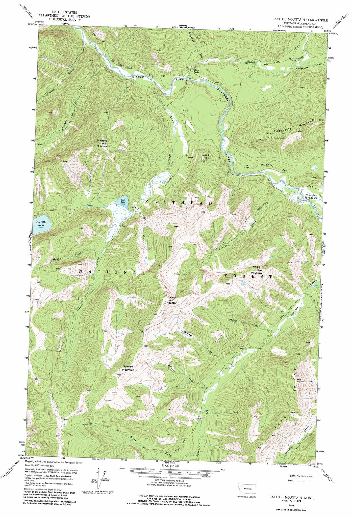
USGS Topo Quad 48113a3 - 1:24,000 scale
| Topo Map Name: | Capitol Mountain |
| USGS Topo Quad ID: | 48113a3 |
| Print Size: | ca. 21 1/4" wide x 27" high |
| Southeast Coordinates: | 48° N latitude / 113.25° W longitude |
| Map Center Coordinates: | 48.0625° N latitude / 113.3125° W longitude |
| U.S. State: | MT |
| Filename: | o48113a3.jpg |
| Download Map JPG Image: | Capitol Mountain topo map 1:24,000 scale |
| Map Type: | Topographic |
| Topo Series: | 7.5´ |
| Map Scale: | 1:24,000 |
| Source of Map Images: | United States Geological Survey (USGS) |
| Alternate Map Versions: |
Capitol Mountain MT 1958, updated 1959 Download PDF Buy paper map Capitol Mountain MT 1958, updated 1973 Download PDF Buy paper map Capitol Mountain MT 1958, updated 1973 Download PDF Buy paper map Capitol Mountain MT 1958, updated 1986 Download PDF Buy paper map Capitol Mountain MT 1994, updated 1996 Download PDF Buy paper map Capitol Mountain MT 2011 Download PDF Buy paper map Capitol Mountain MT 2014 Download PDF Buy paper map |
| FStopo: | US Forest Service topo Capitol Mountain is available: Download FStopo PDF Download FStopo TIF |
1:24,000 Topo Quads surrounding Capitol Mountain
Essex |
Blacktail |
Summit |
Hyde Creek |
Half Dome Crag |
Nimrod |
Mount Bradley |
Red Plume Mountain |
Crescent Cliff |
Morningstar Mountain |
Circus Peak |
Horseshoe Peak |
Capitol Mountain |
Gable Peaks |
Gooseberry Peak |
Tin Creek |
Spotted Bear Mountain |
Whitcomb Peak |
Trilobite Peak |
Pentagon Mountain |
String Creek |
Meadow Creek |
Cathedral Peak |
Bungalow Mountain |
Three Sisters |
> Back to 48113a1 at 1:100,000 scale
> Back to 48112a1 at 1:250,000 scale
> Back to U.S. Topo Maps home
Capitol Mountain topo map: Gazetteer
Capitol Mountain: Airports
Schafer-US Forest Service Airport elevation 1501m 4924′Capitol Mountain: Bridges
Three Forks Pack Bridge elevation 1404m 4606′Capitol Mountain: Lakes
Scott Lake elevation 1481m 4858′Capitol Mountain: Populated Places
Three Forks elevation 1405m 4609′Capitol Mountain: Ridges
Dean Ridge elevation 2109m 6919′Capitol Mountain: Streams
Bore Creek elevation 1484m 4868′Bradley Creek elevation 1365m 4478′
Brushshack Creek elevation 1407m 4616′
Capitol Creek elevation 1523m 4996′
Dryad Creek elevation 1360m 4461′
Guard Creek elevation 1504m 4934′
Lake Creek elevation 1371m 4498′
Lodgepole Creek elevation 1451m 4760′
Miner Creek elevation 1482m 4862′
Morrison Creek elevation 1397m 4583′
Porter Creek elevation 1458m 4783′
Rambler Creek elevation 1536m 5039′
Roaring Creek elevation 1486m 4875′
Rouge Creek elevation 1504m 4934′
Schafer Creek elevation 1467m 4812′
Capitol Mountain: Summits
Capitol Mountain elevation 2393m 7851′Helmet Point elevation 1710m 5610′
Soakem Mountain elevation 2282m 7486′
Union Mountain elevation 2321m 7614′
Wildrose Mountain elevation 2209m 7247′
Capitol Mountain: Trails
Miner Creek Trail elevation 1604m 5262′Capitol Mountain digital topo map on disk
Buy this Capitol Mountain topo map showing relief, roads, GPS coordinates and other geographical features, as a high-resolution digital map file on DVD: