Horseshoe Peak Topo Map Montana
To zoom in, hover over the map of Horseshoe Peak
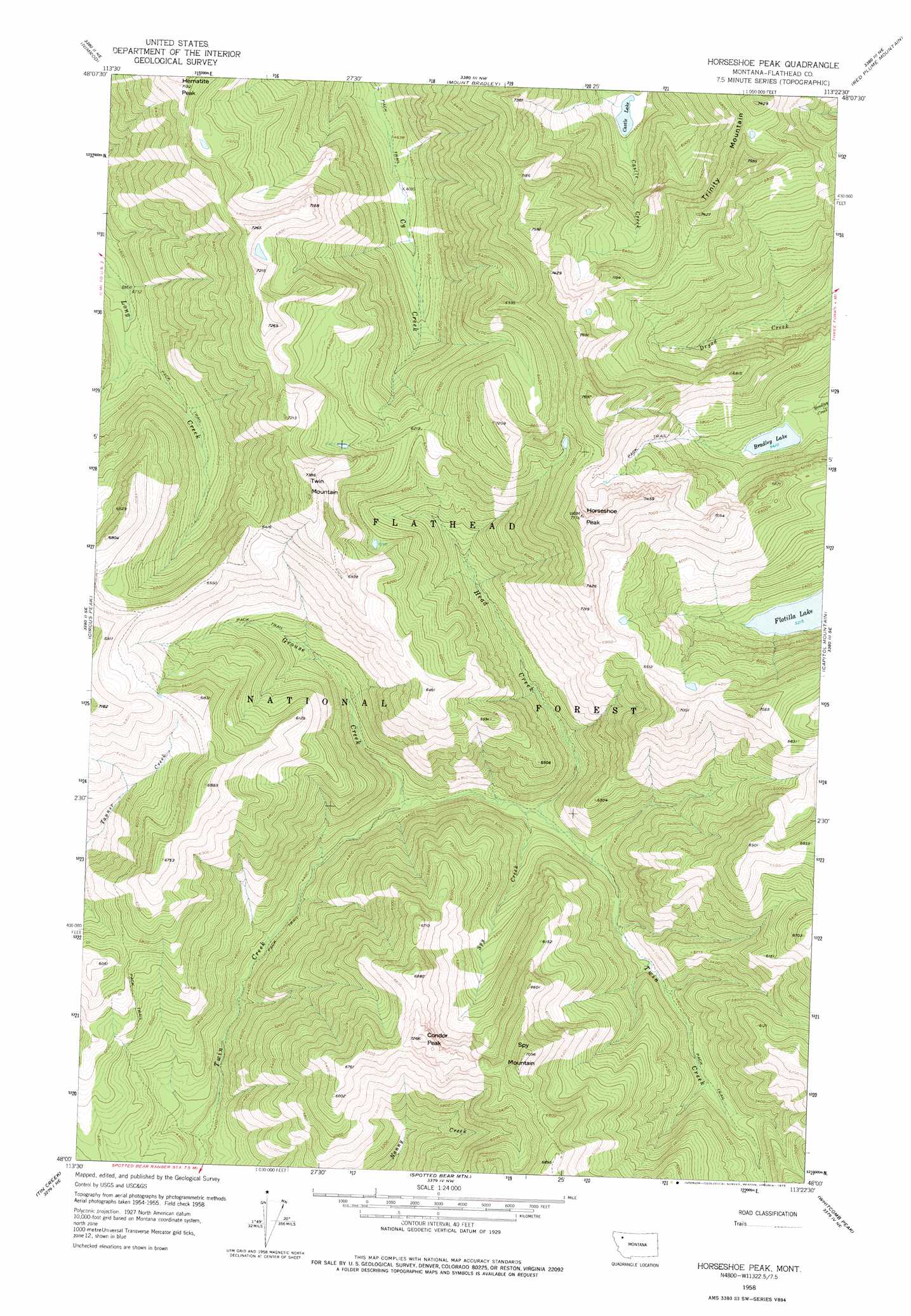
USGS Topo Quad 48113a4 - 1:24,000 scale
| Topo Map Name: | Horseshoe Peak |
| USGS Topo Quad ID: | 48113a4 |
| Print Size: | ca. 21 1/4" wide x 27" high |
| Southeast Coordinates: | 48° N latitude / 113.375° W longitude |
| Map Center Coordinates: | 48.0625° N latitude / 113.4375° W longitude |
| U.S. State: | MT |
| Filename: | o48113a4.jpg |
| Download Map JPG Image: | Horseshoe Peak topo map 1:24,000 scale |
| Map Type: | Topographic |
| Topo Series: | 7.5´ |
| Map Scale: | 1:24,000 |
| Source of Map Images: | United States Geological Survey (USGS) |
| Alternate Map Versions: |
Horseshoe Peak MT 1958, updated 1960 Download PDF Buy paper map Horseshoe Peak MT 1958, updated 1975 Download PDF Buy paper map Horseshoe Peak MT 1994, updated 1997 Download PDF Buy paper map Horseshoe Peak MT 2011 Download PDF Buy paper map Horseshoe Peak MT 2014 Download PDF Buy paper map |
| FStopo: | US Forest Service topo Horseshoe Peak is available: Download FStopo PDF Download FStopo TIF |
1:24,000 Topo Quads surrounding Horseshoe Peak
Pinnacle |
Essex |
Blacktail |
Summit |
Hyde Creek |
Felix Peak |
Nimrod |
Mount Bradley |
Red Plume Mountain |
Crescent Cliff |
Quintonkon |
Circus Peak |
Horseshoe Peak |
Capitol Mountain |
Gable Peaks |
Connor Creek |
Tin Creek |
Spotted Bear Mountain |
Whitcomb Peak |
Trilobite Peak |
Thunderbolt Mountain |
String Creek |
Meadow Creek |
Cathedral Peak |
Bungalow Mountain |
> Back to 48113a1 at 1:100,000 scale
> Back to 48112a1 at 1:250,000 scale
> Back to U.S. Topo Maps home
Horseshoe Peak topo map: Gazetteer
Horseshoe Peak: Lakes
Bradley Lake elevation 1650m 5413′Castle Lake elevation 1580m 5183′
Flotilla Lake elevation 1591m 5219′
Horseshoe Peak: Streams
Castle Creek elevation 1595m 5232′Grouse Creek elevation 1346m 4416′
Head Creek elevation 1370m 4494′
Spy Creek elevation 1366m 4481′
Horseshoe Peak: Summits
Condor Peak elevation 2194m 7198′Hematite Peak elevation 2184m 7165′
Horseshoe Peak elevation 2319m 7608′
Spy Mountain elevation 2165m 7103′
Trinity Mountain elevation 2310m 7578′
Twin Mountain elevation 2234m 7329′
Horseshoe Peak digital topo map on disk
Buy this Horseshoe Peak topo map showing relief, roads, GPS coordinates and other geographical features, as a high-resolution digital map file on DVD: