Big Hawk Mountain Topo Map Montana
To zoom in, hover over the map of Big Hawk Mountain
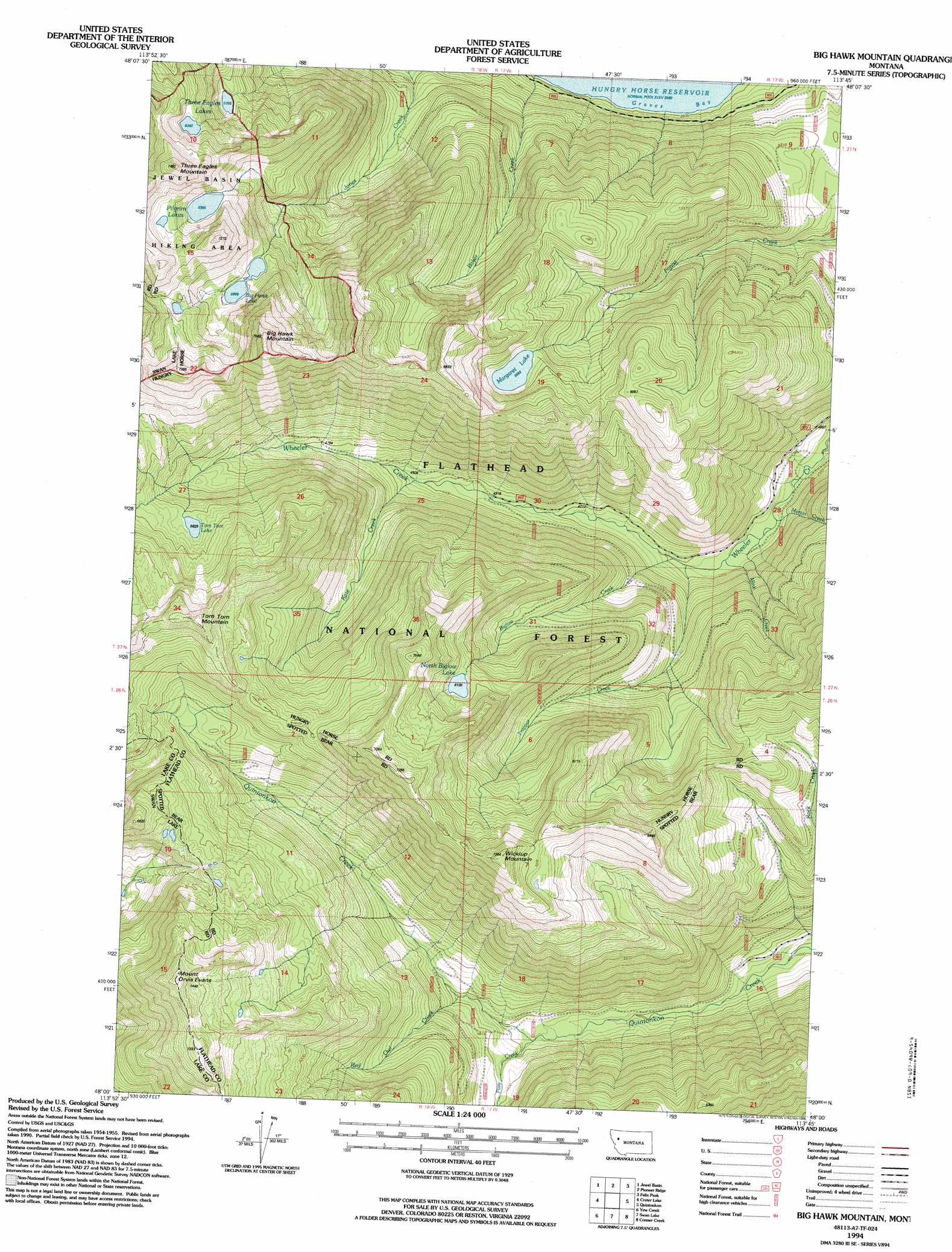
USGS Topo Quad 48113a7 - 1:24,000 scale
| Topo Map Name: | Big Hawk Mountain |
| USGS Topo Quad ID: | 48113a7 |
| Print Size: | ca. 21 1/4" wide x 27" high |
| Southeast Coordinates: | 48° N latitude / 113.75° W longitude |
| Map Center Coordinates: | 48.0625° N latitude / 113.8125° W longitude |
| U.S. State: | MT |
| Filename: | o48113a7.jpg |
| Download Map JPG Image: | Big Hawk Mountain topo map 1:24,000 scale |
| Map Type: | Topographic |
| Topo Series: | 7.5´ |
| Map Scale: | 1:24,000 |
| Source of Map Images: | United States Geological Survey (USGS) |
| Alternate Map Versions: |
Big Hawk Mountain MT 1964, updated 1968 Download PDF Buy paper map Big Hawk Mountain MT 1994, updated 1996 Download PDF Buy paper map Big Hawk Mountain MT 2011 Download PDF Buy paper map Big Hawk Mountain MT 2014 Download PDF Buy paper map |
| FStopo: | US Forest Service topo Big Hawk Mountain is available: Download FStopo PDF Download FStopo TIF |
1:24,000 Topo Quads surrounding Big Hawk Mountain
Doris Mountain |
Nyack Sw |
Mount Grant |
Pinnacle |
Essex |
Hash Mountain |
Jewel Basin |
Pioneer Ridge |
Felix Peak |
Nimrod |
Bigfork |
Crater Lake |
Big Hawk Mountain |
Quintonkon |
Circus Peak |
Woods Bay |
Yew Creek |
Swan Lake |
Connor Creek |
Tin Creek |
Bull Island |
Porcupine Creek |
Cilly Creek |
Thunderbolt Mountain |
String Creek |
> Back to 48113a1 at 1:100,000 scale
> Back to 48112a1 at 1:250,000 scale
> Back to U.S. Topo Maps home
Big Hawk Mountain topo map: Gazetteer
Big Hawk Mountain: Bays
Graves Bay elevation 1086m 3562′Big Hawk Mountain: Lakes
Big Hawk Lake elevation 1829m 6000′Margaret Lake elevation 1733m 5685′
North Biglow Lake elevation 1871m 6138′
Pilgrim Lakes elevation 1941m 6368′
Three Eagles Lakes elevation 1740m 5708′
Tom Tom Lake elevation 1777m 5830′
Big Hawk Mountain: Streams
Baker Creek elevation 1097m 3599′Biglow Creek elevation 1216m 3989′
Kate Creek elevation 1351m 4432′
Martin Creek elevation 1190m 3904′
Mink Creek elevation 1200m 3937′
Posy Creek elevation 1325m 4347′
Red Owl Creek elevation 1387m 4550′
Trapper Creek elevation 1208m 3963′
Big Hawk Mountain: Summits
Big Hawk Mountain elevation 2277m 7470′Mount Orvis Evans elevation 2266m 7434′
Three Eagles Mountain elevation 2270m 7447′
Tom Tom Mountain elevation 2151m 7057′
Wickiup Mountain elevation 2216m 7270′
Big Hawk Mountain digital topo map on disk
Buy this Big Hawk Mountain topo map showing relief, roads, GPS coordinates and other geographical features, as a high-resolution digital map file on DVD: