Red Plume Mountain Topo Map Montana
To zoom in, hover over the map of Red Plume Mountain
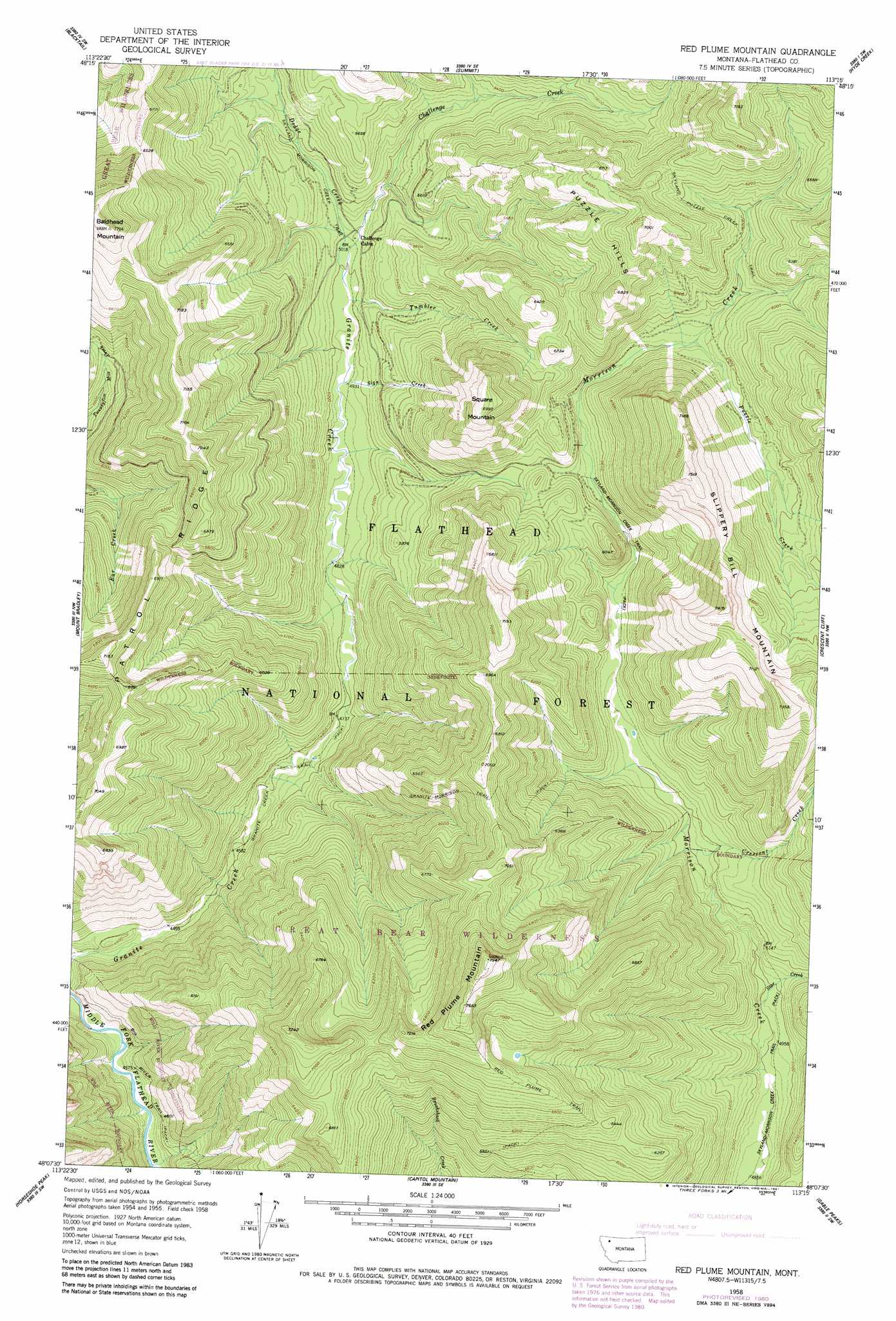
USGS Topo Quad 48113b3 - 1:24,000 scale
| Topo Map Name: | Red Plume Mountain |
| USGS Topo Quad ID: | 48113b3 |
| Print Size: | ca. 21 1/4" wide x 27" high |
| Southeast Coordinates: | 48.125° N latitude / 113.25° W longitude |
| Map Center Coordinates: | 48.1875° N latitude / 113.3125° W longitude |
| U.S. State: | MT |
| Filename: | o48113b3.jpg |
| Download Map JPG Image: | Red Plume Mountain topo map 1:24,000 scale |
| Map Type: | Topographic |
| Topo Series: | 7.5´ |
| Map Scale: | 1:24,000 |
| Source of Map Images: | United States Geological Survey (USGS) |
| Alternate Map Versions: |
Red Plume Mountain MT 1958, updated 1959 Download PDF Buy paper map Red Plume Mountain MT 1958, updated 1975 Download PDF Buy paper map Red Plume Mountain MT 1958, updated 1981 Download PDF Buy paper map Red Plume Mountain MT 1994, updated 1997 Download PDF Buy paper map Red Plume Mountain MT 2011 Download PDF Buy paper map Red Plume Mountain MT 2014 Download PDF Buy paper map |
| FStopo: | US Forest Service topo Red Plume Mountain is available: Download FStopo PDF Download FStopo TIF |
1:24,000 Topo Quads surrounding Red Plume Mountain
Mount Saint Nicholas |
Mount Rockwell |
Squaw Mountain |
East Glacier Park |
Big Rock |
Essex |
Blacktail |
Summit |
Hyde Creek |
Half Dome Crag |
Nimrod |
Mount Bradley |
Red Plume Mountain |
Crescent Cliff |
Morningstar Mountain |
Circus Peak |
Horseshoe Peak |
Capitol Mountain |
Gable Peaks |
Gooseberry Peak |
Tin Creek |
Spotted Bear Mountain |
Whitcomb Peak |
Trilobite Peak |
Pentagon Mountain |
> Back to 48113a1 at 1:100,000 scale
> Back to 48112a1 at 1:250,000 scale
> Back to U.S. Topo Maps home
Red Plume Mountain topo map: Gazetteer
Red Plume Mountain: Ridges
Patrol Ridge elevation 2096m 6876′Red Plume Mountain: Streams
Challenge Creek elevation 1523m 4996′Crescent Creek elevation 1567m 5141′
Dodge Creek elevation 1523m 4996′
Puzzle Creek elevation 1720m 5643′
Sign Creek elevation 1505m 4937′
Star Creek elevation 1510m 4954′
Tumbler Creek elevation 1520m 4986′
Red Plume Mountain: Summits
Baldhead Mountain elevation 2374m 7788′Puzzle Hills elevation 1996m 6548′
Red Plume Mountain elevation 2420m 7939′
Slippery Bill Mountain elevation 2262m 7421′
Square Mountain elevation 2130m 6988′
Red Plume Mountain: Trails
Granite Creek Trail elevation 1410m 4625′Granite-Morrison Trail elevation 1979m 6492′
Red Plume Trail elevation 2069m 6788′
Skyland-Morrison Creek Trail elevation 1713m 5620′
Skyland-Puzzle Creek Trail elevation 1928m 6325′
Red Plume Mountain digital topo map on disk
Buy this Red Plume Mountain topo map showing relief, roads, GPS coordinates and other geographical features, as a high-resolution digital map file on DVD: