Mount Grant Topo Map Montana
To zoom in, hover over the map of Mount Grant
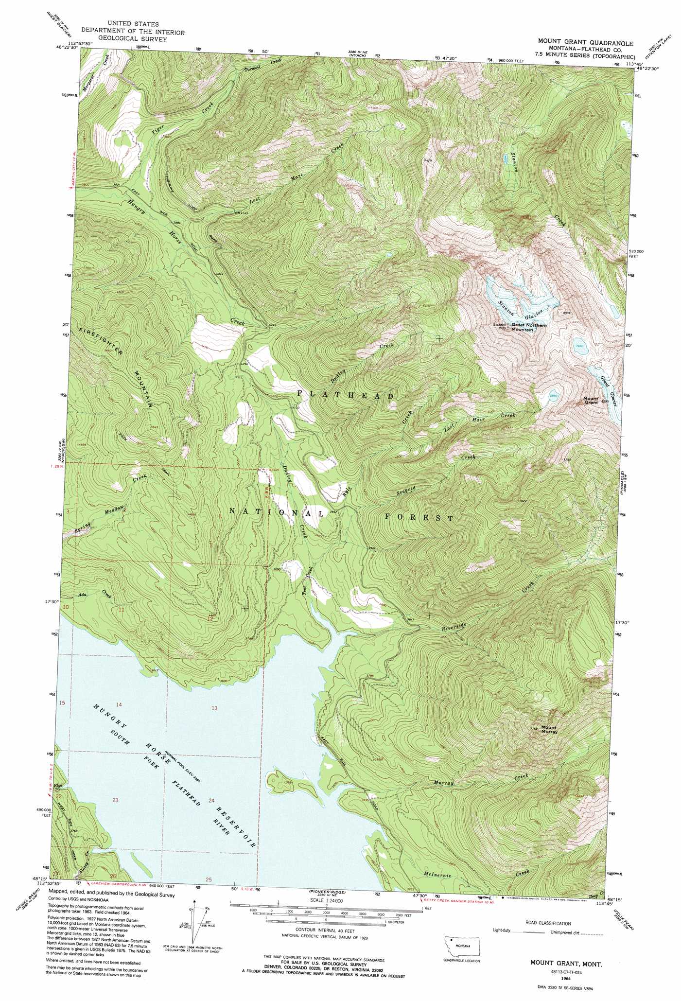
USGS Topo Quad 48113c7 - 1:24,000 scale
| Topo Map Name: | Mount Grant |
| USGS Topo Quad ID: | 48113c7 |
| Print Size: | ca. 21 1/4" wide x 27" high |
| Southeast Coordinates: | 48.25° N latitude / 113.75° W longitude |
| Map Center Coordinates: | 48.3125° N latitude / 113.8125° W longitude |
| U.S. State: | MT |
| Filename: | o48113c7.jpg |
| Download Map JPG Image: | Mount Grant topo map 1:24,000 scale |
| Map Type: | Topographic |
| Topo Series: | 7.5´ |
| Map Scale: | 1:24,000 |
| Source of Map Images: | United States Geological Survey (USGS) |
| Alternate Map Versions: |
Mount Grant MT 1964, updated 1968 Download PDF Buy paper map Mount Grant MT 1964, updated 1992 Download PDF Buy paper map Mount Grant MT 1994, updated 1997 Download PDF Buy paper map Mount Grant MT 2011 Download PDF Buy paper map Mount Grant MT 2014 Download PDF Buy paper map |
| FStopo: | US Forest Service topo Mount Grant is available: Download FStopo PDF Download FStopo TIF |
1:24,000 Topo Quads surrounding Mount Grant
Mcgee Meadow |
Lake Mcdonald West |
Lake Mcdonald East |
Mount Jackson |
Mount Stimson |
Hungry Horse |
West Glacier |
Nyack |
Stanton Lake |
Mount Saint Nicholas |
Doris Mountain |
Nyack Sw |
Mount Grant |
Pinnacle |
Essex |
Hash Mountain |
Jewel Basin |
Pioneer Ridge |
Felix Peak |
Nimrod |
Bigfork |
Crater Lake |
Big Hawk Mountain |
Quintonkon |
Circus Peak |
> Back to 48113a1 at 1:100,000 scale
> Back to 48112a1 at 1:250,000 scale
> Back to U.S. Topo Maps home
Mount Grant topo map: Gazetteer
Mount Grant: Bays
Riverside Bay elevation 1086m 3562′Mount Grant: Glaciers
Grant Glacier elevation 2420m 7939′Stanton Glacier elevation 2528m 8293′
Mount Grant: Islands
Kelly Island elevation 1098m 3602′Mount Grant: Streams
Dudley Creek elevation 1109m 3638′Elya Creek elevation 1086m 3562′
Flossy Creek elevation 1089m 3572′
Lost Hair Creek elevation 1436m 4711′
Lost Mare Creek elevation 1177m 3861′
McInernie Creek elevation 1090m 3576′
Murray Creek elevation 1087m 3566′
Riverside Creek elevation 1086m 3562′
Ryle Creek elevation 1109m 3638′
Seagrid Creek elevation 1137m 3730′
Tent Creek elevation 1086m 3562′
Tiger Creek elevation 1158m 3799′
Turmoil Creek elevation 1256m 4120′
Mount Grant: Summits
Great Northern Mountain elevation 2609m 8559′Mount Grant elevation 2618m 8589′
Mount Murray elevation 2162m 7093′
Mount Grant digital topo map on disk
Buy this Mount Grant topo map showing relief, roads, GPS coordinates and other geographical features, as a high-resolution digital map file on DVD: