Horse Lake Topo Map Montana
To zoom in, hover over the map of Horse Lake
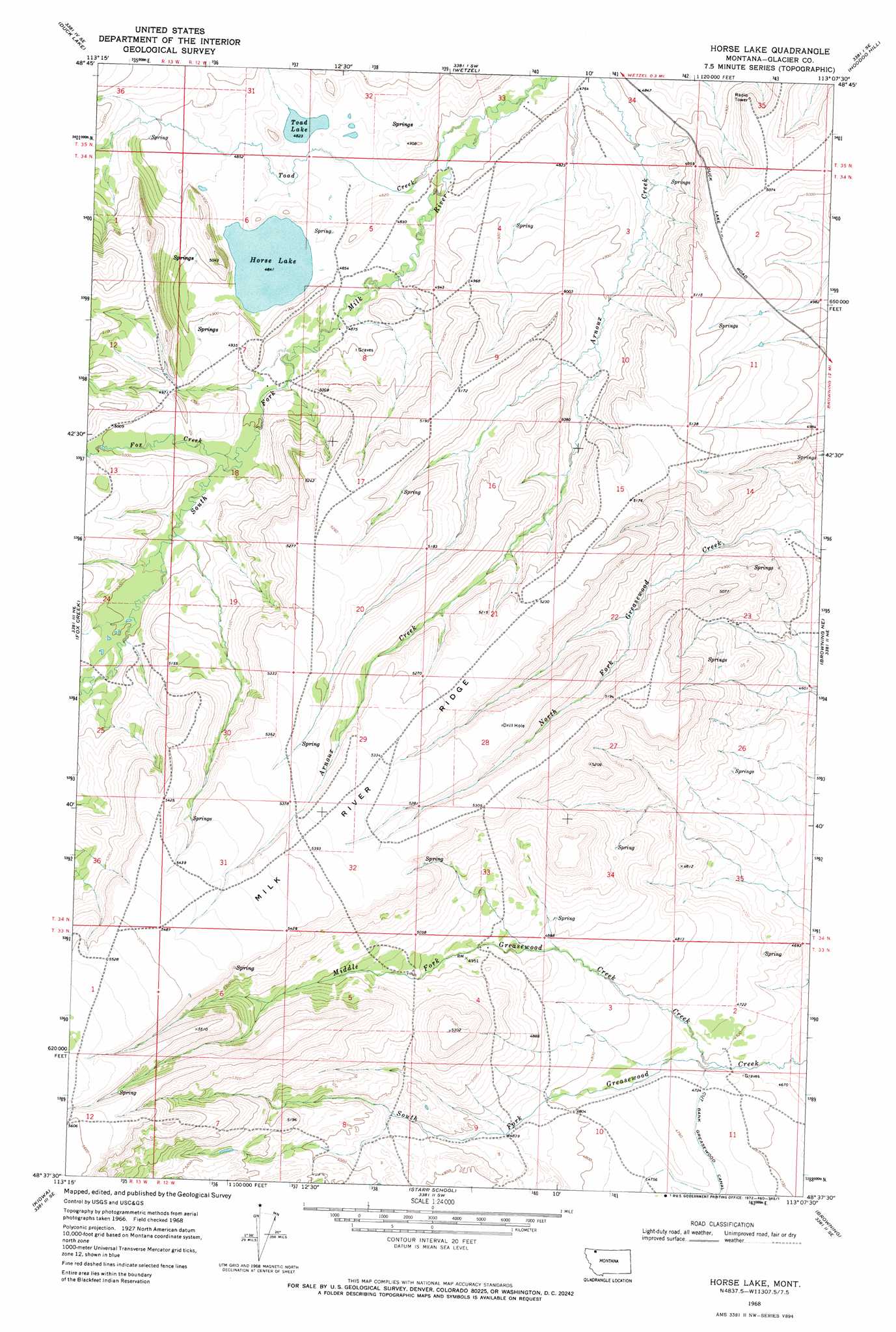
USGS Topo Quad 48113f2 - 1:24,000 scale
| Topo Map Name: | Horse Lake |
| USGS Topo Quad ID: | 48113f2 |
| Print Size: | ca. 21 1/4" wide x 27" high |
| Southeast Coordinates: | 48.625° N latitude / 113.125° W longitude |
| Map Center Coordinates: | 48.6875° N latitude / 113.1875° W longitude |
| U.S. State: | MT |
| Filename: | o48113f2.jpg |
| Download Map JPG Image: | Horse Lake topo map 1:24,000 scale |
| Map Type: | Topographic |
| Topo Series: | 7.5´ |
| Map Scale: | 1:24,000 |
| Source of Map Images: | United States Geological Survey (USGS) |
| Alternate Map Versions: |
Horse Lake MT 1968, updated 1972 Download PDF Buy paper map Horse Lake MT 2011 Download PDF Buy paper map Horse Lake MT 2014 Download PDF Buy paper map |
1:24,000 Topo Quads surrounding Horse Lake
Pike Lake |
Goose Lake |
Hall Coulee |
Emigrant Gap |
Bushnell Hill |
Babb |
Duck Lake |
Wetzel |
Hoodoo Hill |
Nightshoot Coulee |
Saint Mary |
Fox Creek |
Horse Lake |
Browning Ne |
Sharp Lake |
Cut Bank Pass |
Kiowa |
Starr School |
Browning |
Blackfoot |
Mount Rockwell |
Squaw Mountain |
East Glacier Park |
Big Rock |
Magee Ranch |
> Back to 48113e1 at 1:100,000 scale
> Back to 48112a1 at 1:250,000 scale
> Back to U.S. Topo Maps home
Horse Lake topo map: Gazetteer
Horse Lake: Canals
Cut Bank Greasewood Canal elevation 1451m 4760′Horse Lake: Lakes
Horse Lake elevation 1477m 4845′Toad Lake elevation 1471m 4826′
Horse Lake: Ridges
Milk River Ridge elevation 1693m 5554′Horse Lake: Springs
34N12W15DABC01 Spring elevation 1525m 5003′34N12W17DABB01 Spring elevation 1564m 5131′
34N12W28CBBA01 Spring elevation 1606m 5269′
Horse Lake: Streams
Fox Creek elevation 1500m 4921′Middle Fork Greasewood Creek elevation 1430m 4691′
Toad Creek elevation 1452m 4763′
Horse Lake: Valleys
Madman Coulee elevation 1535m 5036′Horse Lake digital topo map on disk
Buy this Horse Lake topo map showing relief, roads, GPS coordinates and other geographical features, as a high-resolution digital map file on DVD: