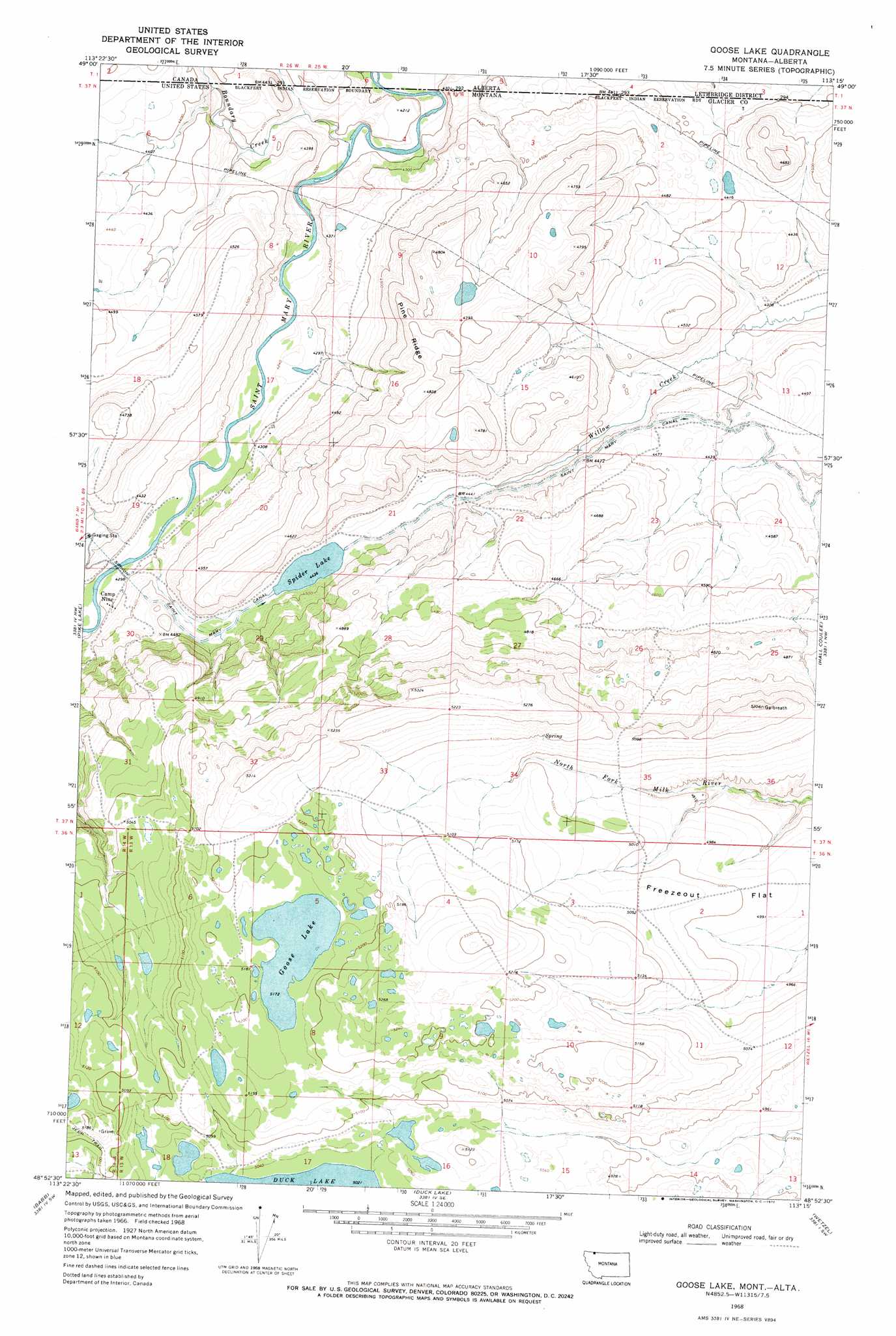
Goose Lake Topo Map Montana
To zoom in, hover over the map of Goose Lake
USGS Topo Quad 48113h3 - 1:24,000 scale
| Topo Map Name: | Goose Lake |
| USGS Topo Quad ID: | 48113h3 |
| Print Size: | ca. 21 1/4" wide x 27" high |
| Southeast Coordinates: | 48.875° N latitude / 113.25° W longitude |
| Map Center Coordinates: | 48.9375° N latitude / 113.3125° W longitude |
| U.S. State: | MT |
| Filename: | o48113h3.jpg |
| Download Map JPG Image: | Goose Lake topo map 1:24,000 scale |
| Map Type: | Topographic |
| Topo Series: | 7.5´ |
| Map Scale: | 1:24,000 |
| Source of Map Images: | United States Geological Survey (USGS) |
| Alternate Map Versions: |
Goose Lake MT 1968, updated 1972 Download PDF Buy paper map Goose Lake MT 1968, updated 1979 Download PDF Buy paper map Goose Lake MT 2011 Download PDF Buy paper map Goose Lake MT 2014 Download PDF Buy paper map |
1:24,000 Topo Quads surrounding Goose Lake
Chief Mountain |
Pike Lake |
Goose Lake |
Hall Coulee |
Emigrant Gap |
Lake Sherburne |
Babb |
Duck Lake |
Wetzel |
Hoodoo Hill |
Rising Sun |
Saint Mary |
Fox Creek |
Horse Lake |
Browning Ne |
> Back to 48113e1 at 1:100,000 scale
> Back to 48112a1 at 1:250,000 scale
> Back to U.S. Topo Maps home
Goose Lake topo map: Gazetteer
Goose Lake: Canals
Saint Mary Canal elevation 1354m 4442′Goose Lake: Dams
Spider Lake Dam elevation 1353m 4438′Goose Lake: Flats
Freezeout Flat elevation 1521m 4990′Goose Lake: Lakes
Goose Lake elevation 1578m 5177′Spider Lake elevation 1353m 4438′
Goose Lake: Post Offices
Fletcher Post Office (historical) elevation 1312m 4304′Goose Lake: Ridges
Pine Ridge elevation 1468m 4816′Goose Lake: Streams
Boundary Creek elevation 1275m 4183′Goose Lake digital topo map on disk
Buy this Goose Lake topo map showing relief, roads, GPS coordinates and other geographical features, as a high-resolution digital map file on DVD: