Hash Mountain Topo Map Montana
To zoom in, hover over the map of Hash Mountain
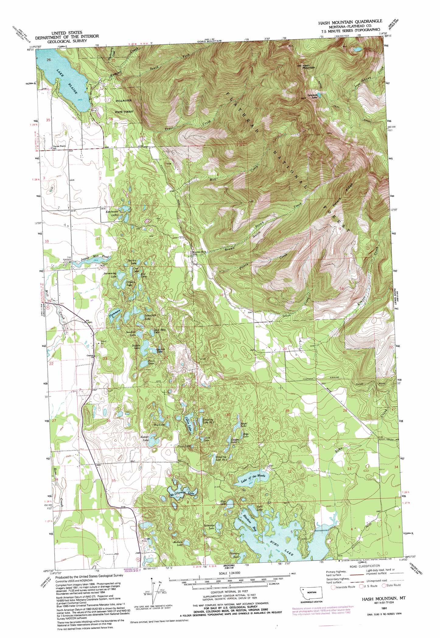
USGS Topo Quad 48114b1 - 1:24,000 scale
| Topo Map Name: | Hash Mountain |
| USGS Topo Quad ID: | 48114b1 |
| Print Size: | ca. 21 1/4" wide x 27" high |
| Southeast Coordinates: | 48.125° N latitude / 114° W longitude |
| Map Center Coordinates: | 48.1875° N latitude / 114.0625° W longitude |
| U.S. State: | MT |
| Filename: | o48114b1.jpg |
| Download Map JPG Image: | Hash Mountain topo map 1:24,000 scale |
| Map Type: | Topographic |
| Topo Series: | 7.5´ |
| Map Scale: | 1:24,000 |
| Source of Map Images: | United States Geological Survey (USGS) |
| Alternate Map Versions: |
Hash Mountain MT 1962, updated 1964 Download PDF Buy paper map Hash Mountain MT 1962, updated 1983 Download PDF Buy paper map Hash Mountain MT 1991, updated 1995 Download PDF Buy paper map Hash Mountain MT 1994, updated 1996 Download PDF Buy paper map Hash Mountain MT 2011 Download PDF Buy paper map Hash Mountain MT 2014 Download PDF Buy paper map |
| FStopo: | US Forest Service topo Hash Mountain is available: Download FStopo PDF Download FStopo TIF |
1:24,000 Topo Quads surrounding Hash Mountain
Whitefish |
Columbia Falls North |
Hungry Horse |
West Glacier |
Nyack |
Rose Crossing |
Columbia Falls South |
Doris Mountain |
Nyack Sw |
Mount Grant |
Kalispell |
Creston |
Hash Mountain |
Jewel Basin |
Pioneer Ridge |
Lion Mountain |
Somers |
Bigfork |
Crater Lake |
Big Hawk Mountain |
Proctor |
Rollins |
Woods Bay |
Yew Creek |
Swan Lake |
> Back to 48114a1 at 1:100,000 scale
> Back to 48114a1 at 1:250,000 scale
> Back to U.S. Topo Maps home
Hash Mountain topo map: Gazetteer
Hash Mountain: Bays
Blackies Bay elevation 918m 3011′Hash Mountain: Dams
Jessup Mill Pond Dam elevation 899m 2949′Hash Mountain: Islands
Firemens Island elevation 918m 3011′Hash Mountain: Lakes
Amy Lake elevation 909m 2982′Angel Lake elevation 909m 2982′
Angels Lake elevation 909m 2982′
Ann Lake elevation 907m 2975′
Basham Lake elevation 908m 2979′
Blue Lake elevation 908m 2979′
Boys Lake elevation 915m 3001′
Cabin Lake elevation 908m 2979′
Circle Lake elevation 908m 2979′
Cougar Lake elevation 913m 2995′
Cree Lake elevation 908m 2979′
Dan Lake elevation 909m 2982′
Double Lake elevation 908m 2979′
Dry Lake elevation 905m 2969′
East Bass Lake elevation 906m 2972′
Echo Lake elevation 918m 3011′
Garlick Lake elevation 908m 2979′
Gilbert Lake elevation 908m 2979′
Grayling Lake Number One elevation 911m 2988′
Grayling Lake Number Two elevation 905m 2969′
Harbin Lake elevation 905m 2969′
John Lake elevation 908m 2979′
Kathy Lake elevation 908m 2979′
Kaufmans Lake elevation 906m 2972′
Kid Lake elevation 906m 2972′
Kohler Lake elevation 906m 2972′
Lake Blaine elevation 913m 2995′
Lake Douglas elevation 908m 2979′
Lake Meredith elevation 906m 2972′
Lake of the Woods elevation 916m 3005′
Lake Peter elevation 905m 2969′
Lamoose Lake elevation 1937m 6354′
McGilvray Lake elevation 908m 2979′
Olive Lake elevation 908m 2979′
Plummers Lake elevation 908m 2979′
Pratt Lake elevation 906m 2972′
Sawdust Lake elevation 907m 2975′
Spill Lake elevation 918m 3011′
Swimming Lake elevation 908m 2979′
Talmadge Lake elevation 913m 2995′
Tamarack Lake elevation 906m 2972′
Hash Mountain: Post Offices
Echo Post Office (historical) elevation 927m 3041′Hash Mountain: Reservoirs
Jessup Mill Pond elevation 896m 2939′Hash Mountain: Ridges
Peters Ridge elevation 1748m 5734′Hash Mountain: Springs
28N20W23BABC01 Spring elevation 896m 2939′Hash Mountain: Streams
Brown Creek elevation 967m 3172′Echo Creek elevation 919m 3015′
Handkerchief Creek elevation 1045m 3428′
Hemler Creek elevation 913m 2995′
Krause Creek elevation 1017m 3336′
Mill Creek elevation 971m 3185′
Noisy Creek elevation 976m 3202′
Olson Creek elevation 1011m 3316′
Peters Creek elevation 1012m 3320′
South Fork Hemler Creek elevation 951m 3120′
Trail Creek elevation 995m 3264′
Hash Mountain: Summits
Hash Mountain elevation 2157m 7076′Hash Mountain: Trails
Alpine Trail elevation 1880m 6167′Hash Mountain: Valleys
Brown Gulch elevation 967m 3172′Hash Mountain: Wells
27N19W04CADD01 Well elevation 936m 3070′27N20W02AB__01 Well elevation 918m 3011′
27N20W02CC__01 Well elevation 891m 2923′
27N20W03AB__01 Well elevation 887m 2910′
27N20W03DC__01 Well elevation 884m 2900′
28N19W07CC__01 Well elevation 991m 3251′
28N19W20DCAA01 Well elevation 999m 3277′
28N20W01BA__01 Well elevation 966m 3169′
28N20W02AB__01 Well elevation 929m 3047′
28N20W02BB__01 Well elevation 928m 3044′
28N20W03AB__01 Well elevation 934m 3064′
28N20W03DD__01 Well elevation 926m 3038′
28N20W03DD__02 Well elevation 926m 3038′
28N20W10AD__01 Well elevation 908m 2979′
28N20W10DC__01 Well elevation 893m 2929′
28N20W10DD__01 Well elevation 892m 2926′
28N20W10DD__02 Well elevation 892m 2926′
28N20W11AC__01 Well elevation 921m 3021′
28N20W11CB__01 Well elevation 905m 2969′
28N20W11CCBC01 Well elevation 898m 2946′
28N20W14ACDA01 Well elevation 910m 2985′
28N20W14CCBC01 Well elevation 898m 2946′
28N20W14CCCB01 Well elevation 897m 2942′
28N20W14CCCB02 Well elevation 897m 2942′
28N20W14CCCC01 Well elevation 893m 2929′
28N20W14CCCC02 Well elevation 894m 2933′
28N20W14CCCC03 Well elevation 893m 2929′
28N20W14CCCC04 Well elevation 893m 2929′
28N20W14CCCD01 Well elevation 896m 2939′
28N20W14CCCD02 Well elevation 895m 2936′
28N20W14CCDA01 Well elevation 898m 2946′
28N20W14CCDA02 Well elevation 898m 2946′
28N20W14CCDB01 Well elevation 897m 2942′
28N20W14CCDD01 Well elevation 896m 2939′
28N20W14CDCC01 Well elevation 909m 2982′
28N20W14CDDC01 Well elevation 904m 2965′
28N20W15AB__01 Well elevation 891m 2923′
28N20W15AD__01 Well elevation 895m 2936′
28N20W15DB__01 Well elevation 891m 2923′
28N20W22AAAB01 Well elevation 888m 2913′
28N20W23BA__01 Well elevation 902m 2959′
28N20W23CA__01 Well elevation 903m 2962′
28N20W25DC__01 Well elevation 933m 3061′
28N20W26BAAA01 Well elevation 918m 3011′
28N20W26BB__01 Well elevation 897m 2942′
28N20W27DD__01 Well elevation 896m 2939′
28N20W34AA__01 Well elevation 891m 2923′
28N20W35AA__01 Well elevation 928m 3044′
29N20W35CD__02 Well elevation 934m 3064′
29N20W35DD__01 Well elevation 934m 3064′
29N20W35DD__02 Well elevation 934m 3064′
29N20W36BAAB01 Well elevation 939m 3080′
29N20W36CD__01 Well elevation 934m 3064′
29N20W36DC__01 Well elevation 934m 3064′
29N21W02AA__01 Well elevation 937m 3074′
Hash Mountain digital topo map on disk
Buy this Hash Mountain topo map showing relief, roads, GPS coordinates and other geographical features, as a high-resolution digital map file on DVD: