Blue Grass Ridge Topo Map Montana
To zoom in, hover over the map of Blue Grass Ridge
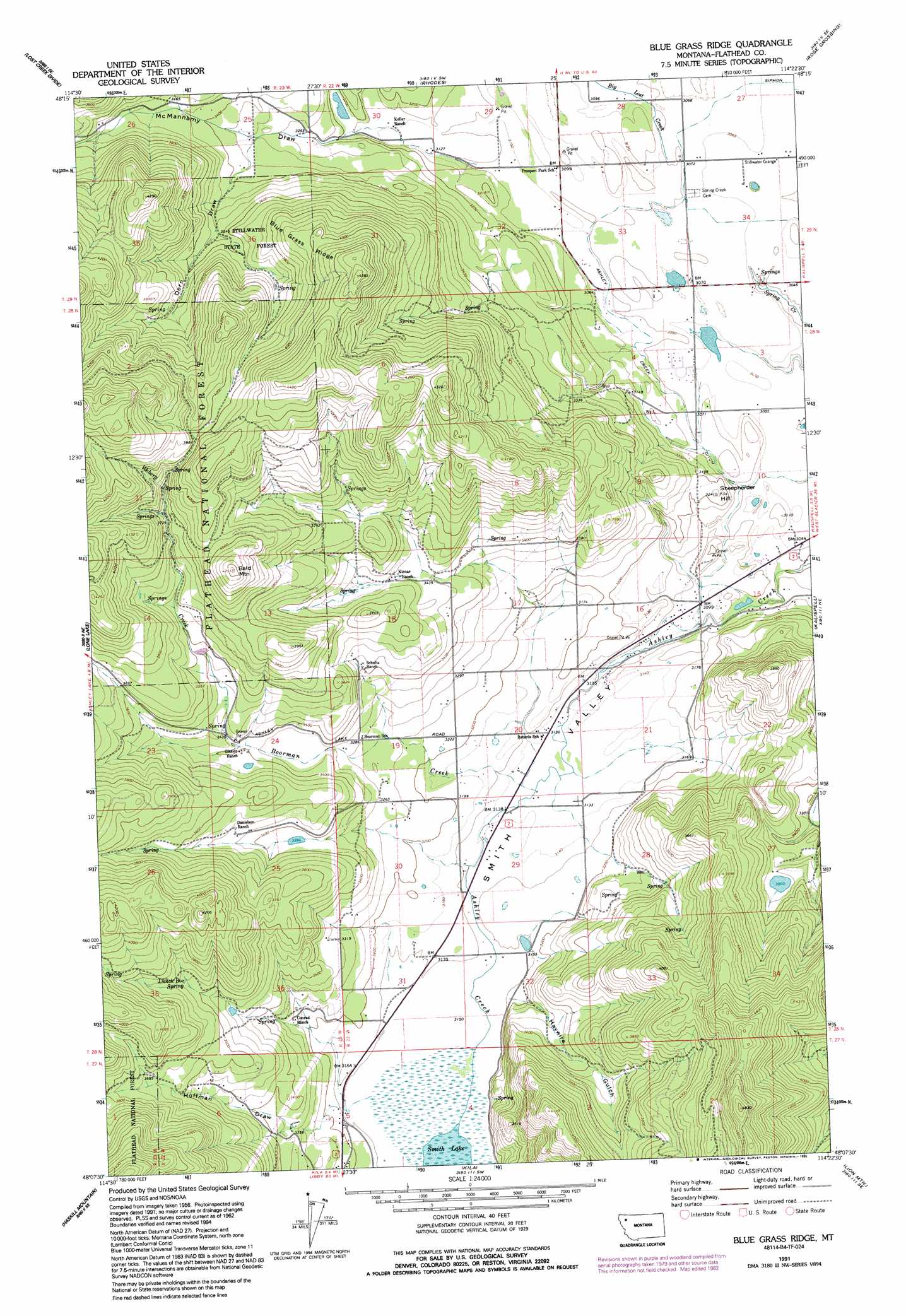
USGS Topo Quad 48114b4 - 1:24,000 scale
| Topo Map Name: | Blue Grass Ridge |
| USGS Topo Quad ID: | 48114b4 |
| Print Size: | ca. 21 1/4" wide x 27" high |
| Southeast Coordinates: | 48.125° N latitude / 114.375° W longitude |
| Map Center Coordinates: | 48.1875° N latitude / 114.4375° W longitude |
| U.S. State: | MT |
| Filename: | o48114b4.jpg |
| Download Map JPG Image: | Blue Grass Ridge topo map 1:24,000 scale |
| Map Type: | Topographic |
| Topo Series: | 7.5´ |
| Map Scale: | 1:24,000 |
| Source of Map Images: | United States Geological Survey (USGS) |
| Alternate Map Versions: |
Blue Grass Ridge MT 1962, updated 1964 Download PDF Buy paper map Blue Grass Ridge MT 1962, updated 1965 Download PDF Buy paper map Blue Grass Ridge MT 1962, updated 1983 Download PDF Buy paper map Blue Grass Ridge MT 1991, updated 1995 Download PDF Buy paper map Blue Grass Ridge MT 1994, updated 1997 Download PDF Buy paper map Blue Grass Ridge MT 2011 Download PDF Buy paper map Blue Grass Ridge MT 2014 Download PDF Buy paper map |
| FStopo: | US Forest Service topo Blue Grass Ridge is available: Download FStopo PDF Download FStopo TIF |
1:24,000 Topo Quads surrounding Blue Grass Ridge
Johnson Peak |
Tally Lake |
Beaver Lake |
Whitefish |
Columbia Falls North |
Ashley Mountain |
Lost Creek Divide |
Rhodes |
Rose Crossing |
Columbia Falls South |
Pleasant Valley Mountain |
Lone Lake |
Blue Grass Ridge |
Kalispell |
Creston |
Marion |
Haskill Mountain |
Kila |
Lion Mountain |
Somers |
Hubbart Reservoir |
Kofford Ridge |
Lake Mary Ronan |
Proctor |
Rollins |
> Back to 48114a1 at 1:100,000 scale
> Back to 48114a1 at 1:250,000 scale
> Back to U.S. Topo Maps home
Blue Grass Ridge topo map: Gazetteer
Blue Grass Ridge: Airports
Mower Field elevation 934m 3064′Blue Grass Ridge: Canals
Ashley Creek Ditch elevation 943m 3093′Blue Grass Ridge: Parks
Batavia Waterfowl Production Area elevation 958m 3143′Blue Grass Ridge: Populated Places
Batavia elevation 953m 3126′Rainbows End Mobile Home Park elevation 947m 3106′
Blue Grass Ridge: Ridges
Blue Grass Ridge elevation 1216m 3989′Blue Grass Ridge: Springs
Lunch Box Spring elevation 1111m 3645′Blue Grass Ridge: Streams
Big Lost Creek elevation 940m 3083′Boorman Creek elevation 955m 3133′
Weberg Creek elevation 1035m 3395′
Blue Grass Ridge: Summits
Bald Mountain elevation 1294m 4245′Sheepherder Hill elevation 990m 3248′
Blue Grass Ridge: Valleys
Dern Draw elevation 1010m 3313′Haywire Gulch elevation 970m 3182′
Hoffman Draw elevation 963m 3159′
McMannamy Draw elevation 952m 3123′
Smith Valley elevation 944m 3097′
Blue Grass Ridge: Wells
28N22W04AD__01 Well elevation 940m 3083′28N22W04DA__01 Well elevation 937m 3074′
28N22W10AA__01 Well elevation 927m 3041′
28N22W15AB__01 Well elevation 930m 3051′
28N22W15CBCC01 Well elevation 954m 3129′
28N22W16ABDD01 Well elevation 969m 3179′
28N22W20ADAB01 Well elevation 953m 3126′
29N22W26BCBC01 Well elevation 933m 3061′
29N22W27CABA01 Well elevation 935m 3067′
29N22W27CC__01 Well elevation 934m 3064′
29N22W27DC__01 Well elevation 934m 3064′
29N22W27DD__01 Well elevation 932m 3057′
29N22W28ACCC01 Well elevation 940m 3083′
29N22W28DDDD01 Well elevation 940m 3083′
29N22W32AA__01 Well elevation 946m 3103′
29N22W32AB__01 Well elevation 949m 3113′
29N22W32AD__01 Well elevation 948m 3110′
29N22W33AB__01 Well elevation 939m 3080′
29N22W33BA__01 Well elevation 953m 3126′
29N22W34CC__01 Well elevation 939m 3080′
29N22W34DD__01 Well elevation 933m 3061′
Blue Grass Ridge digital topo map on disk
Buy this Blue Grass Ridge topo map showing relief, roads, GPS coordinates and other geographical features, as a high-resolution digital map file on DVD: