Sylvia Lake Topo Map Montana
To zoom in, hover over the map of Sylvia Lake
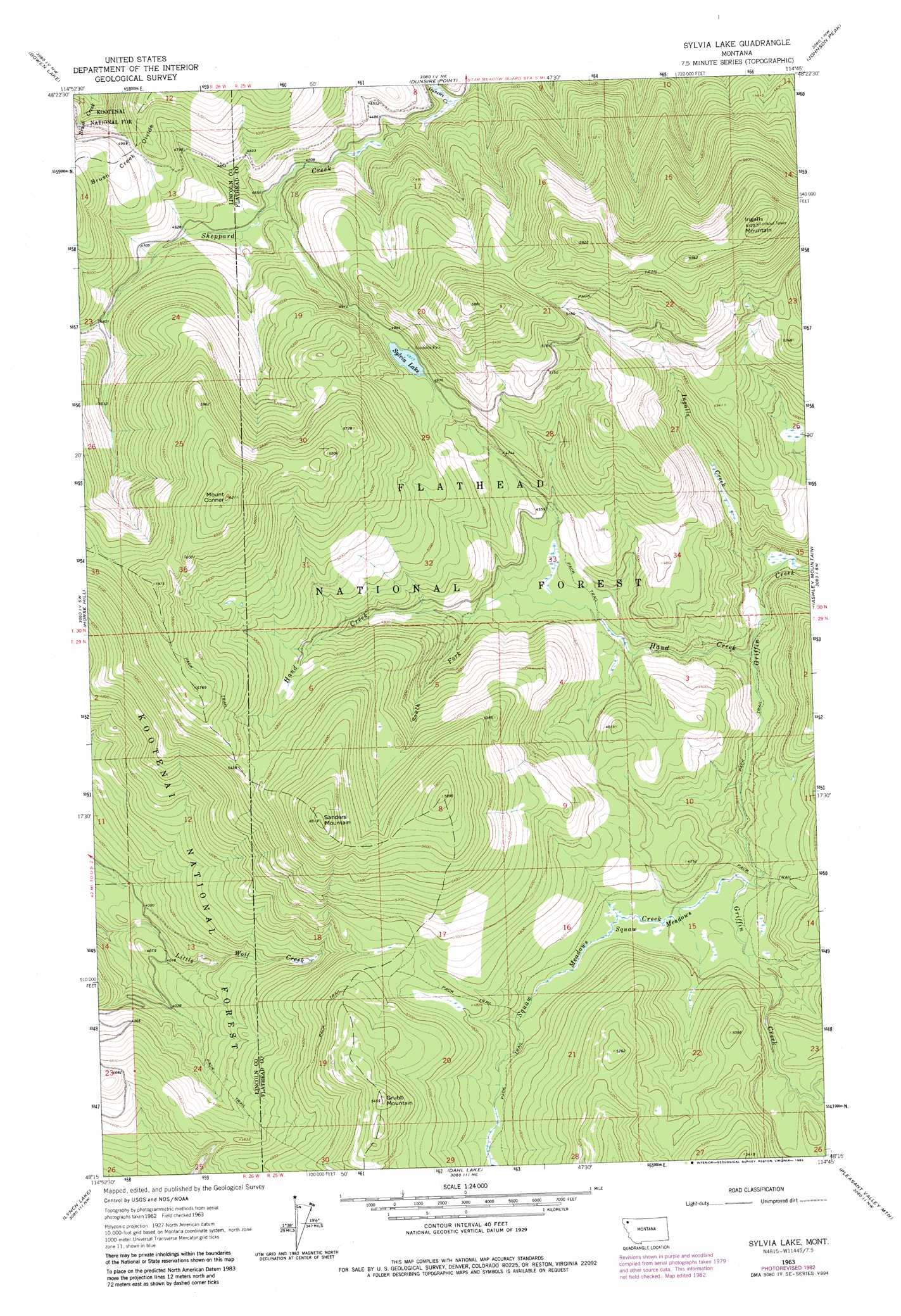
USGS Topo Quad 48114c7 - 1:24,000 scale
| Topo Map Name: | Sylvia Lake |
| USGS Topo Quad ID: | 48114c7 |
| Print Size: | ca. 21 1/4" wide x 27" high |
| Southeast Coordinates: | 48.25° N latitude / 114.75° W longitude |
| Map Center Coordinates: | 48.3125° N latitude / 114.8125° W longitude |
| U.S. State: | MT |
| Filename: | o48114c7.jpg |
| Download Map JPG Image: | Sylvia Lake topo map 1:24,000 scale |
| Map Type: | Topographic |
| Topo Series: | 7.5´ |
| Map Scale: | 1:24,000 |
| Source of Map Images: | United States Geological Survey (USGS) |
| Alternate Map Versions: |
Sylvia Lake MT 1963, updated 1966 Download PDF Buy paper map Sylvia Lake MT 1963, updated 1966 Download PDF Buy paper map Sylvia Lake MT 1963, updated 1983 Download PDF Buy paper map Sylvia Lake MT 1994, updated 1997 Download PDF Buy paper map Sylvia Lake MT 2011 Download PDF Buy paper map Sylvia Lake MT 2014 Download PDF Buy paper map |
| FStopo: | US Forest Service topo Sylvia Lake is available: Download FStopo PDF Download FStopo TIF |
1:24,000 Topo Quads surrounding Sylvia Lake
Davis Mountain |
Skillet Mountain |
Sunday Mountain |
Radnor |
Olney |
Warland Peak |
Bowen Lake |
Dunsire Point |
Johnson Peak |
Tally Lake |
Wolf Prairie |
Horse Hill |
Sylvia Lake |
Ashley Mountain |
Lost Creek Divide |
Deer Creek |
Lynch Lake |
Dahl Lake |
Pleasant Valley Mountain |
Lone Lake |
Thompson Lakes |
Meadow Peak |
Mcgregor Peak |
Marion |
Haskill Mountain |
> Back to 48114a1 at 1:100,000 scale
> Back to 48114a1 at 1:250,000 scale
> Back to U.S. Topo Maps home
Sylvia Lake topo map: Gazetteer
Sylvia Lake: Flats
Squaw Meadows elevation 1374m 4507′Sylvia Lake: Lakes
Sylvia Lake elevation 1500m 4921′Sylvia Lake: Ridges
Brush Creek Divide elevation 1528m 5013′Sylvia Lake: Streams
Dunsire Creek elevation 1329m 4360′Hand Creek elevation 1299m 4261′
Ingalls Creek elevation 1263m 4143′
South Fork Hand Creek elevation 1384m 4540′
Squaw Meadows Creek elevation 1366m 4481′
Sylvia Lake: Summits
Grubb Mountain elevation 1662m 5452′Ingalls Mountain elevation 1868m 6128′
Mount Conner elevation 1888m 6194′
Sanders Mountain elevation 1832m 6010′
Sylvia Lake: Trails
Griffin Creek Trail elevation 1371m 4498′Sylvia Lake digital topo map on disk
Buy this Sylvia Lake topo map showing relief, roads, GPS coordinates and other geographical features, as a high-resolution digital map file on DVD: