Johnson Peak Topo Map Montana
To zoom in, hover over the map of Johnson Peak
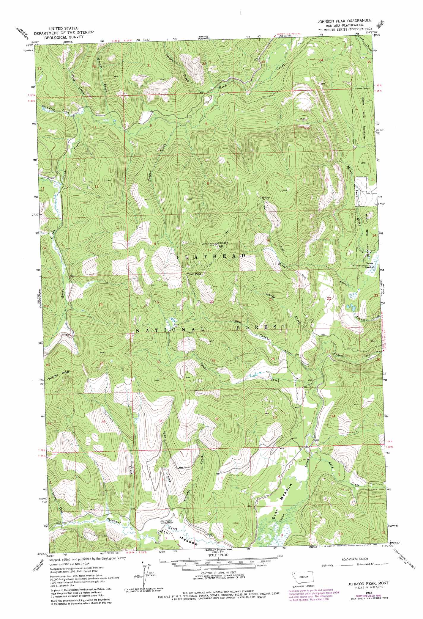
USGS Topo Quad 48114d6 - 1:24,000 scale
| Topo Map Name: | Johnson Peak |
| USGS Topo Quad ID: | 48114d6 |
| Print Size: | ca. 21 1/4" wide x 27" high |
| Southeast Coordinates: | 48.375° N latitude / 114.625° W longitude |
| Map Center Coordinates: | 48.4375° N latitude / 114.6875° W longitude |
| U.S. State: | MT |
| Filename: | o48114d6.jpg |
| Download Map JPG Image: | Johnson Peak topo map 1:24,000 scale |
| Map Type: | Topographic |
| Topo Series: | 7.5´ |
| Map Scale: | 1:24,000 |
| Source of Map Images: | United States Geological Survey (USGS) |
| Alternate Map Versions: |
Johnson Peak MT 1962, updated 1964 Download PDF Buy paper map Johnson Peak MT 1962, updated 1983 Download PDF Buy paper map Johnson Peak MT 1994, updated 1997 Download PDF Buy paper map Johnson Peak MT 2011 Download PDF Buy paper map Johnson Peak MT 2014 Download PDF Buy paper map |
| FStopo: | US Forest Service topo Johnson Peak is available: Download FStopo PDF Download FStopo TIF |
1:24,000 Topo Quads surrounding Johnson Peak
Edna Mountain |
Stryker |
Bull Lake |
Upper Whitefish Lake |
Moose Peak |
Skillet Mountain |
Sunday Mountain |
Radnor |
Olney |
Werner Peak |
Bowen Lake |
Dunsire Point |
Johnson Peak |
Tally Lake |
Beaver Lake |
Horse Hill |
Sylvia Lake |
Ashley Mountain |
Lost Creek Divide |
Rhodes |
Lynch Lake |
Dahl Lake |
Pleasant Valley Mountain |
Lone Lake |
Blue Grass Ridge |
> Back to 48114a1 at 1:100,000 scale
> Back to 48114a1 at 1:250,000 scale
> Back to U.S. Topo Maps home
Johnson Peak topo map: Gazetteer
Johnson Peak: Flats
Shorts Meadow elevation 1105m 3625′Johnson Peak: Gaps
Trixie Pass elevation 1620m 5314′Johnson Peak: Mines
Humdinger Mine elevation 1198m 3930′Yukon Mine elevation 1254m 4114′
Johnson Peak: Streams
Alder Creek elevation 1274m 4179′Corduroy Creek elevation 1265m 4150′
East Sanko Creek elevation 1194m 3917′
Gergen Creek elevation 1265m 4150′
Gregg Creek elevation 1268m 4160′
Grouse Creek elevation 1254m 4114′
Nelson Creek elevation 1218m 3996′
Reid Creek elevation 1219m 3999′
Sanko Creek elevation 1204m 3950′
Sinclair Creek elevation 1216m 3989′
Smoke Creek elevation 1103m 3618′
Star Creek elevation 1219m 3999′
Swaney Creek elevation 1233m 4045′
Swanson Creek elevation 1227m 4025′
Trixie Creek elevation 1233m 4045′
Johnson Peak: Summits
Johnson Peak elevation 1832m 6010′Johnson Peak digital topo map on disk
Buy this Johnson Peak topo map showing relief, roads, GPS coordinates and other geographical features, as a high-resolution digital map file on DVD: