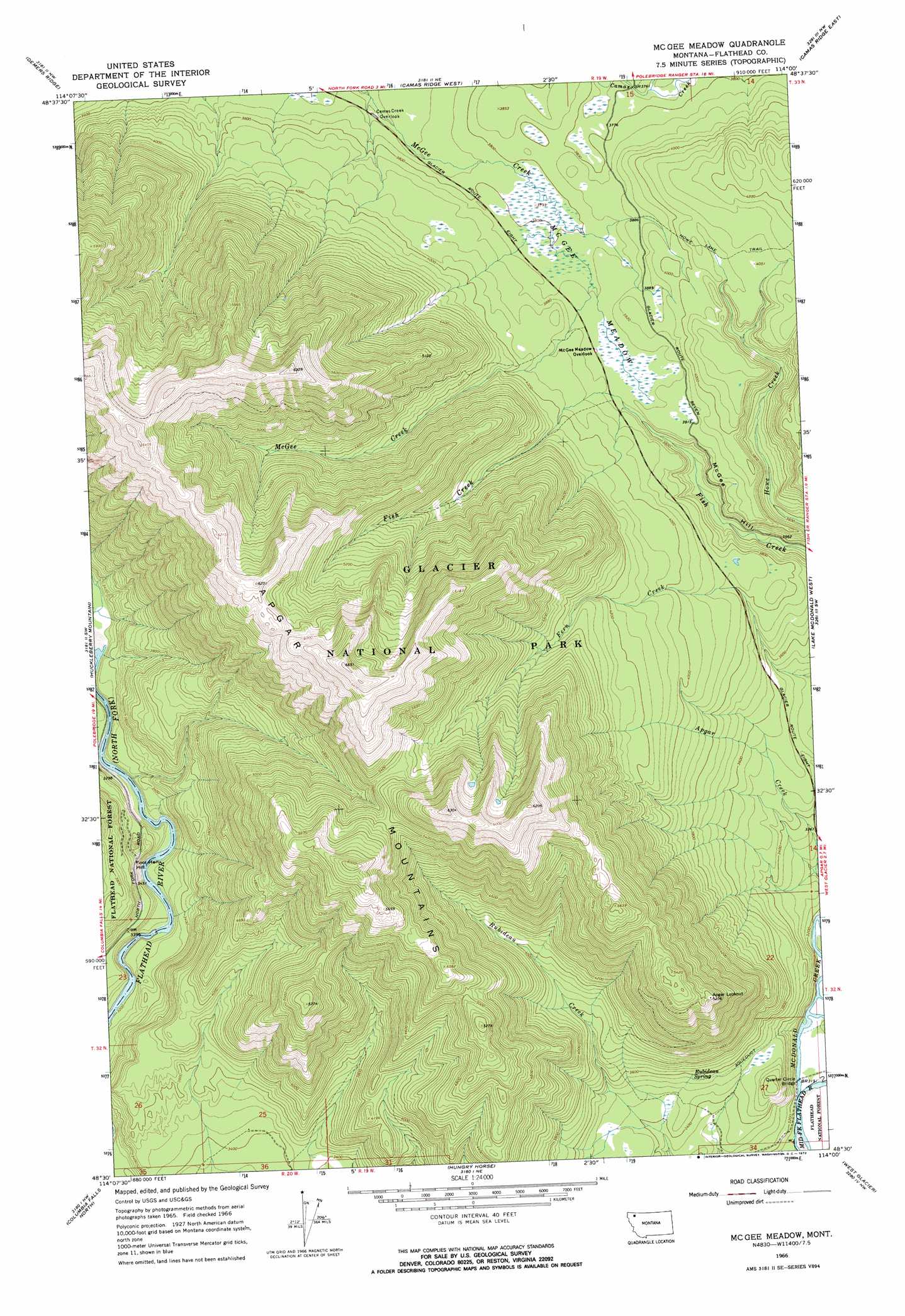
Mcgee Meadow Topo Map Montana
To zoom in, hover over the map of Mcgee Meadow
USGS Topo Quad 48114e1 - 1:24,000 scale
| Topo Map Name: | Mcgee Meadow |
| USGS Topo Quad ID: | 48114e1 |
| Print Size: | ca. 21 1/4" wide x 27" high |
| Southeast Coordinates: | 48.5° N latitude / 114° W longitude |
| Map Center Coordinates: | 48.5625° N latitude / 114.0625° W longitude |
| U.S. State: | MT |
| Filename: | o48114e1.jpg |
| Download Map JPG Image: | Mcgee Meadow topo map 1:24,000 scale |
| Map Type: | Topographic |
| Topo Series: | 7.5´ |
| Map Scale: | 1:24,000 |
| Source of Map Images: | United States Geological Survey (USGS) |
| Alternate Map Versions: |
Mc Gee Meadow MT 1966, updated 1971 Download PDF Buy paper map Mc Gee Meadow MT 1966, updated 1972 Download PDF Buy paper map Mc Gee Meadow MT 1994, updated 1997 Download PDF Buy paper map McGee Meadow MT 2011 Download PDF Buy paper map McGee Meadow MT 2014 Download PDF Buy paper map |
| FStopo: | US Forest Service topo McGee Meadow is available: Download FStopo PDF Download FStopo TIF |
1:24,000 Topo Quads surrounding Mcgee Meadow
Polebridge |
Quartz Ridge |
Vulture Peak |
Mount Geduhn |
Ahern Pass |
Cyclone Lake |
Demers Ridge |
Camas Ridge West |
Camas Ridge East |
Mount Cannon |
Skookoleel Creek |
Huckleberry Mountain |
Mcgee Meadow |
Lake Mcdonald West |
Lake Mcdonald East |
Whitefish |
Columbia Falls North |
Hungry Horse |
West Glacier |
Nyack |
Rose Crossing |
Columbia Falls South |
Doris Mountain |
Nyack Sw |
Mount Grant |
> Back to 48114e1 at 1:100,000 scale
> Back to 48114a1 at 1:250,000 scale
> Back to U.S. Topo Maps home
Mcgee Meadow topo map: Gazetteer
Mcgee Meadow: Bridges
Quarter Circle Bridge elevation 957m 3139′Mcgee Meadow: Cliffs
McGee Hill elevation 1164m 3818′Mcgee Meadow: Flats
McGee Meadow elevation 1174m 3851′Mcgee Meadow: Ridges
Apgar Mountains elevation 1916m 6286′Mcgee Meadow: Springs
Rubideau Spring elevation 1092m 3582′Mcgee Meadow: Streams
Howe Creek elevation 1094m 3589′McDonald Creek elevation 957m 3139′
Mcgee Meadow: Trails
Howe Lake Trail elevation 1234m 4048′Mcgee Meadow: Wells
32N19W26BCCC01 Well elevation 962m 3156′32N19W27ADAA01 Well elevation 960m 3149′
32N19W27ADAB01 Well elevation 958m 3143′
32N19W27ADAD01 Well elevation 961m 3152′
32N19W27ADAD02 Well elevation 961m 3152′
32N19W27ADAD03 Well elevation 960m 3149′
32N19W27ADCD01 Well elevation 957m 3139′
32N19W27ADDA01 Well elevation 961m 3152′
Mcgee Meadow digital topo map on disk
Buy this Mcgee Meadow topo map showing relief, roads, GPS coordinates and other geographical features, as a high-resolution digital map file on DVD: