Olney Topo Map Montana
To zoom in, hover over the map of Olney
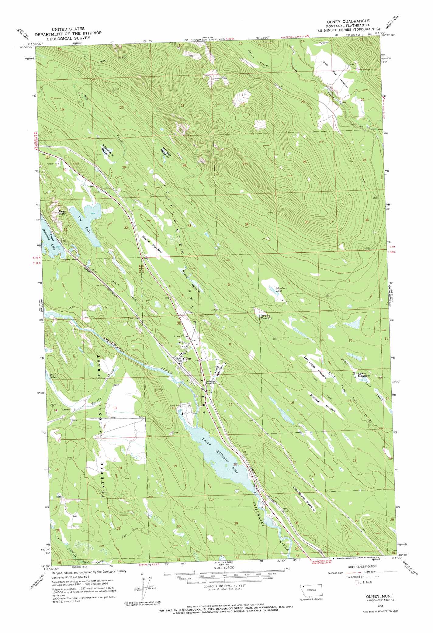
USGS Topo Quad 48114e5 - 1:24,000 scale
| Topo Map Name: | Olney |
| USGS Topo Quad ID: | 48114e5 |
| Print Size: | ca. 21 1/4" wide x 27" high |
| Southeast Coordinates: | 48.5° N latitude / 114.5° W longitude |
| Map Center Coordinates: | 48.5625° N latitude / 114.5625° W longitude |
| U.S. State: | MT |
| Filename: | o48114e5.jpg |
| Download Map JPG Image: | Olney topo map 1:24,000 scale |
| Map Type: | Topographic |
| Topo Series: | 7.5´ |
| Map Scale: | 1:24,000 |
| Source of Map Images: | United States Geological Survey (USGS) |
| Alternate Map Versions: |
Olney MT 1966, updated 1971 Download PDF Buy paper map Olney MT 1994, updated 1997 Download PDF Buy paper map Olney MT 2011 Download PDF Buy paper map Olney MT 2014 Download PDF Buy paper map |
| FStopo: | US Forest Service topo Olney is available: Download FStopo PDF Download FStopo TIF |
1:24,000 Topo Quads surrounding Olney
Mount Marston |
Mount Thompson-Seton |
Red Meadow Lake |
Whale Buttes |
Polebridge |
Stryker |
Bull Lake |
Upper Whitefish Lake |
Moose Peak |
Cyclone Lake |
Sunday Mountain |
Radnor |
Olney |
Werner Peak |
Skookoleel Creek |
Dunsire Point |
Johnson Peak |
Tally Lake |
Beaver Lake |
Whitefish |
Sylvia Lake |
Ashley Mountain |
Lost Creek Divide |
Rhodes |
Rose Crossing |
> Back to 48114e1 at 1:100,000 scale
> Back to 48114a1 at 1:250,000 scale
> Back to U.S. Topo Maps home
Olney topo map: Gazetteer
Olney: Flats
Bear Paw Meadow elevation 1237m 4058′Bootjack Meadow elevation 1049m 3441′
Lake House Meadow elevation 1012m 3320′
Lazy Creek Meadow elevation 1050m 3444′
Lewis Meadow elevation 1060m 3477′
Long Meadow elevation 966m 3169′
McCabe Meadow elevation 1106m 3628′
Purple Meadow elevation 973m 3192′
Ritsenburg Meadow elevation 1046m 3431′
Round Meadow elevation 1035m 3395′
Ruppel Meadow elevation 1018m 3339′
Skunk Meadow elevation 1024m 3359′
Olney: Lakes
Dog Lake elevation 984m 3228′Lower Stillwater Lake elevation 931m 3054′
Meadow Lake elevation 1062m 3484′
Olney: Populated Places
Olney elevation 966m 3169′Olney: Post Offices
Mock Post Office (historical) elevation 983m 3225′Olney Post Office elevation 968m 3175′
Olney: Streams
Antice Creek elevation 1214m 3982′Dog Creek elevation 941m 3087′
Martin Creek elevation 952m 3123′
Potter Creek elevation 1050m 3444′
Olney: Summits
Dog Mountain elevation 1114m 3654′Olney: Wells
32N23W07AC__01 Well elevation 972m 3188′32N23W07BABB01 Well elevation 970m 3182′
32N23W08CAD_01 Well elevation 1035m 3395′
32N23W17BB__01 Well elevation 964m 3162′
32N23W17BBBC01 Well elevation 964m 3162′
33N23W30BDBD01 Well elevation 991m 3251′
33N23W32DD__01 Well elevation 1024m 3359′
Olney digital topo map on disk
Buy this Olney topo map showing relief, roads, GPS coordinates and other geographical features, as a high-resolution digital map file on DVD: