Cyclone Lake Topo Map Montana
To zoom in, hover over the map of Cyclone Lake
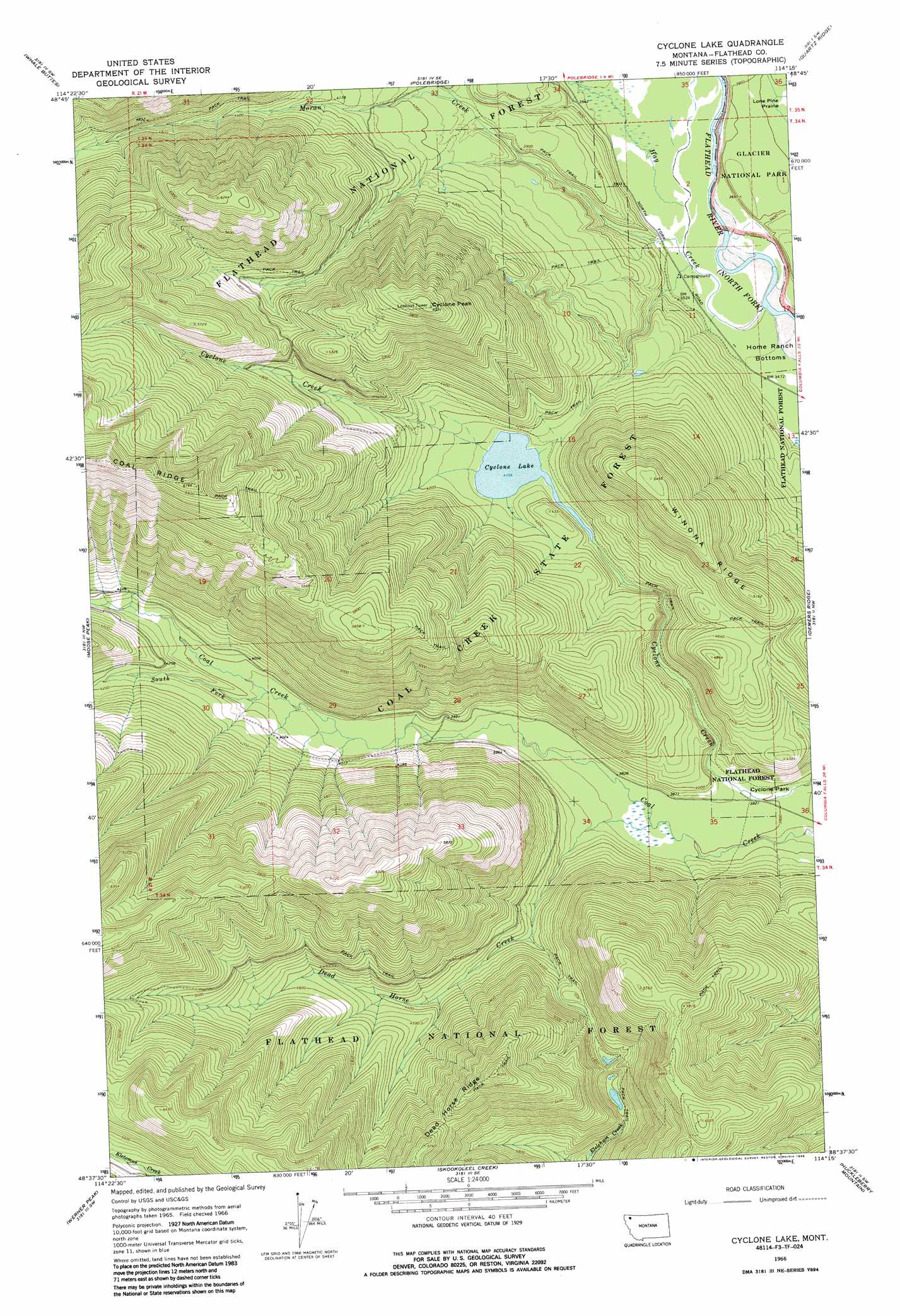
USGS Topo Quad 48114f3 - 1:24,000 scale
| Topo Map Name: | Cyclone Lake |
| USGS Topo Quad ID: | 48114f3 |
| Print Size: | ca. 21 1/4" wide x 27" high |
| Southeast Coordinates: | 48.625° N latitude / 114.25° W longitude |
| Map Center Coordinates: | 48.6875° N latitude / 114.3125° W longitude |
| U.S. State: | MT |
| Filename: | o48114f3.jpg |
| Download Map JPG Image: | Cyclone Lake topo map 1:24,000 scale |
| Map Type: | Topographic |
| Topo Series: | 7.5´ |
| Map Scale: | 1:24,000 |
| Source of Map Images: | United States Geological Survey (USGS) |
| Alternate Map Versions: |
Cyclone Lake MT 1966, updated 1971 Download PDF Buy paper map Cyclone Lake MT 1966, updated 1986 Download PDF Buy paper map Cyclone Lake MT 2011 Download PDF Buy paper map Cyclone Lake MT 2014 Download PDF Buy paper map |
| FStopo: | US Forest Service topo Cyclone Lake is available: Download FStopo PDF Download FStopo TIF |
1:24,000 Topo Quads surrounding Cyclone Lake
Mount Hefty |
Trailcreek |
Kintla Lake |
Kintla Peak |
Mount Carter |
Red Meadow Lake |
Whale Buttes |
Polebridge |
Quartz Ridge |
Vulture Peak |
Upper Whitefish Lake |
Moose Peak |
Cyclone Lake |
Demers Ridge |
Camas Ridge West |
Olney |
Werner Peak |
Skookoleel Creek |
Huckleberry Mountain |
Mcgee Meadow |
Tally Lake |
Beaver Lake |
Whitefish |
Columbia Falls North |
Hungry Horse |
> Back to 48114e1 at 1:100,000 scale
> Back to 48114a1 at 1:250,000 scale
> Back to U.S. Topo Maps home
Cyclone Lake topo map: Gazetteer
Cyclone Lake: Flats
Cyclone Park elevation 1163m 3815′Lone Pine Prairie elevation 1094m 3589′
Cyclone Lake: Forests
Coal Creek State Forest elevation 1328m 4356′Cyclone Lake: Lakes
Cyclone Lake elevation 1252m 4107′Elelehum lake elevation 1334m 4376′
Cyclone Lake: Ridges
Dead Horse Ridge elevation 1650m 5413′Winona Ridge elevation 1563m 5127′
Cyclone Lake: Streams
Dead Horse Creek elevation 1163m 3815′Hay Creek elevation 1061m 3480′
Moran Creek elevation 1069m 3507′
South Fork Coal Creek elevation 1204m 3950′
Cyclone Lake: Summits
Cyclone Peak elevation 1838m 6030′Cyclone Lake digital topo map on disk
Buy this Cyclone Lake topo map showing relief, roads, GPS coordinates and other geographical features, as a high-resolution digital map file on DVD: