Howard Lake Topo Map Montana
To zoom in, hover over the map of Howard Lake
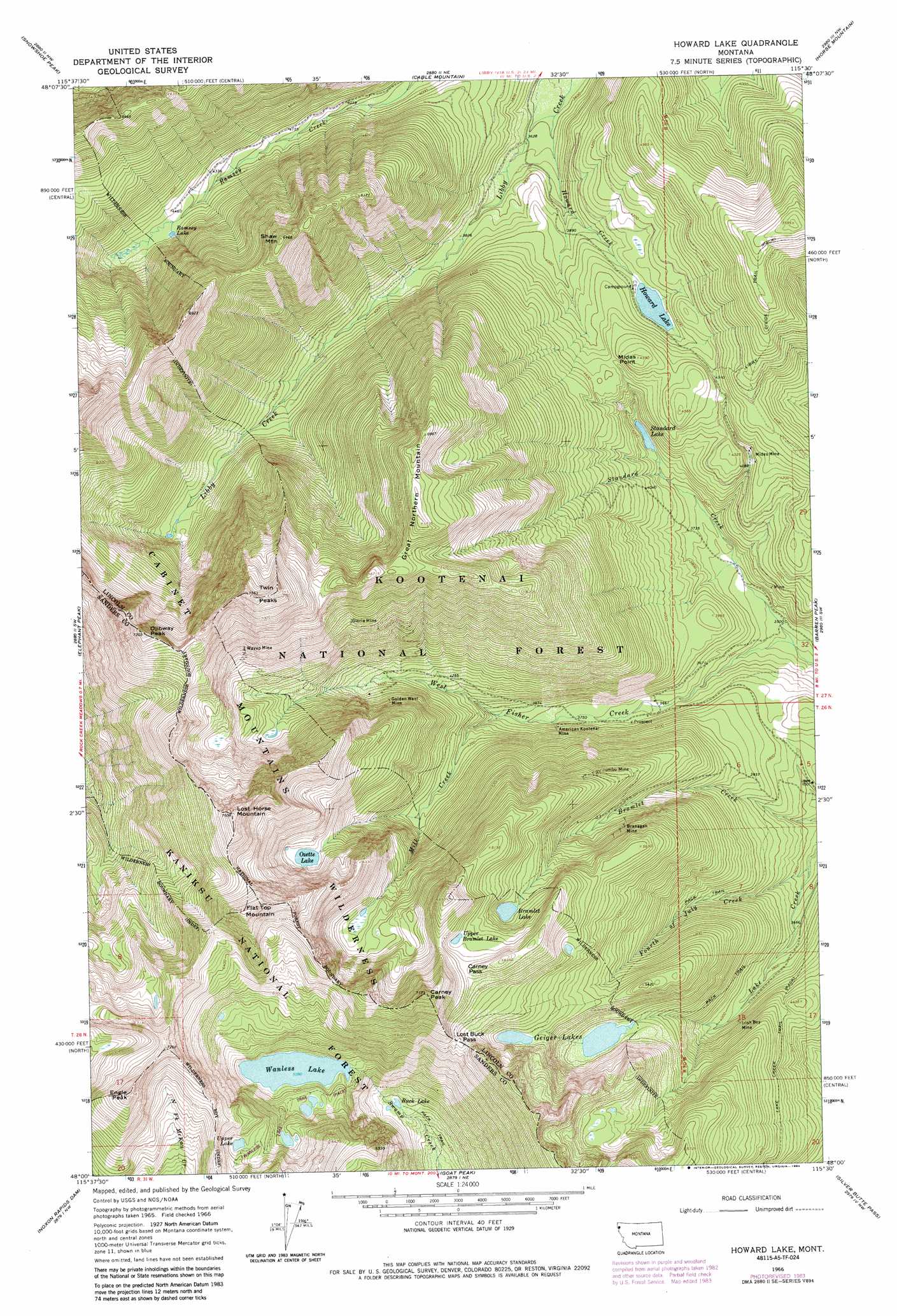
USGS Topo Quad 48115a5 - 1:24,000 scale
| Topo Map Name: | Howard Lake |
| USGS Topo Quad ID: | 48115a5 |
| Print Size: | ca. 21 1/4" wide x 27" high |
| Southeast Coordinates: | 48° N latitude / 115.5° W longitude |
| Map Center Coordinates: | 48.0625° N latitude / 115.5625° W longitude |
| U.S. State: | MT |
| Filename: | o48115a5.jpg |
| Download Map JPG Image: | Howard Lake topo map 1:24,000 scale |
| Map Type: | Topographic |
| Topo Series: | 7.5´ |
| Map Scale: | 1:24,000 |
| Source of Map Images: | United States Geological Survey (USGS) |
| Alternate Map Versions: |
Howard Lake MT 1966, updated 1970 Download PDF Buy paper map Howard Lake MT 1966, updated 1981 Download PDF Buy paper map Howard Lake MT 1966, updated 1984 Download PDF Buy paper map Howard Lake MT 1997, updated 2000 Download PDF Buy paper map Howard Lake MT 2011 Download PDF Buy paper map Howard Lake MT 2014 Download PDF Buy paper map |
| FStopo: | US Forest Service topo Howard Lake is available: Download FStopo PDF Download FStopo TIF |
1:24,000 Topo Quads surrounding Howard Lake
Crowell Mountain |
Treasure Mountain |
Little Hoodo Mountain |
Swede Mountain |
Tony Peak |
Ibex Peak |
Snowshoe Peak |
Cable Mountain |
Horse Mountain |
Fisher Mountain |
Smeads Bench |
Elephant Peak |
Howard Lake |
Barren Peak |
Kenelty Mountain |
Noxon |
Noxon Rapids Dam |
Goat Peak |
Silver Butte Pass |
Miller Lake |
Bloom Peak |
Larchwood |
Trout Creek |
Seven Point Mountain |
Vermilion Peak |
> Back to 48115a1 at 1:100,000 scale
> Back to 48114a1 at 1:250,000 scale
> Back to U.S. Topo Maps home
Howard Lake topo map: Gazetteer
Howard Lake: Gaps
Carney Pass elevation 1882m 6174′Lost Buck Pass elevation 1802m 5912′
Howard Lake: Lakes
Bramlet Lake elevation 1701m 5580′Buck Lake elevation 1340m 4396′
Geiger Lakes elevation 1445m 4740′
Howard Lake elevation 1250m 4101′
Ozette Lake elevation 1677m 5501′
Ramsey Lake elevation 1350m 4429′
Standard Lake elevation 1177m 3861′
Upper Bramlet Lake elevation 1835m 6020′
Upper Lake elevation 1807m 5928′
Wanless Lake elevation 1553m 5095′
Howard Lake: Mines
American Kootenai Mine elevation 1210m 3969′American Kootenai Mine elevation 1170m 3838′
Bramlet Creek Mine elevation 1657m 5436′
Branagan Mine elevation 1509m 4950′
Branagan Mine elevation 1451m 4760′
Geiger Lakes Mine elevation 1497m 4911′
Gloria Mine elevation 1680m 5511′
Gloria Mine elevation 1736m 5695′
Golden West Mine elevation 1454m 4770′
Golden West Mine elevation 1451m 4760′
Great Northern Mine elevation 1766m 5793′
Howard Lake Mine elevation 1205m 3953′
Irish Boy Mine elevation 1239m 4064′
Irish Boy Mine elevation 1311m 4301′
Jumbo Mine elevation 1508m 4947′
Jumbo Mine elevation 1566m 5137′
Libby Creek Mine elevation 1468m 4816′
Midas Mine elevation 1295m 4248′
Montezuma Mine elevation 1088m 3569′
Rainbow Mine elevation 1467m 4812′
Standard Creek Mine elevation 1107m 3631′
Wayup Mine elevation 1818m 5964′
Wayup Mine elevation 1815m 5954′
West Fisher Creek Mine elevation 1179m 3868′
Howard Lake: Post Offices
Cabinet Post Office (historical) elevation 1110m 3641′Howard Lake: Streams
Fourth of July Creek elevation 1072m 3517′Howard Creek elevation 1095m 3592′
Mill Creek elevation 1176m 3858′
Standard Creek elevation 1051m 3448′
Howard Lake: Summits
Carney Peak elevation 2091m 6860′Engle Peak elevation 2285m 7496′
Flat Top Mountain elevation 2319m 7608′
Great Northern Mountain elevation 2085m 6840′
Lost Horse Mountain elevation 2274m 7460′
Midas Point elevation 1391m 4563′
Ojibway Peak elevation 2166m 7106′
Shaw Mountain elevation 1957m 6420′
Twin Peaks elevation 2258m 7408′
Howard Lake: Trails
Lake Creek Trail elevation 1358m 4455′Howard Lake digital topo map on disk
Buy this Howard Lake topo map showing relief, roads, GPS coordinates and other geographical features, as a high-resolution digital map file on DVD: