Treasure Mountain Topo Map Montana
To zoom in, hover over the map of Treasure Mountain
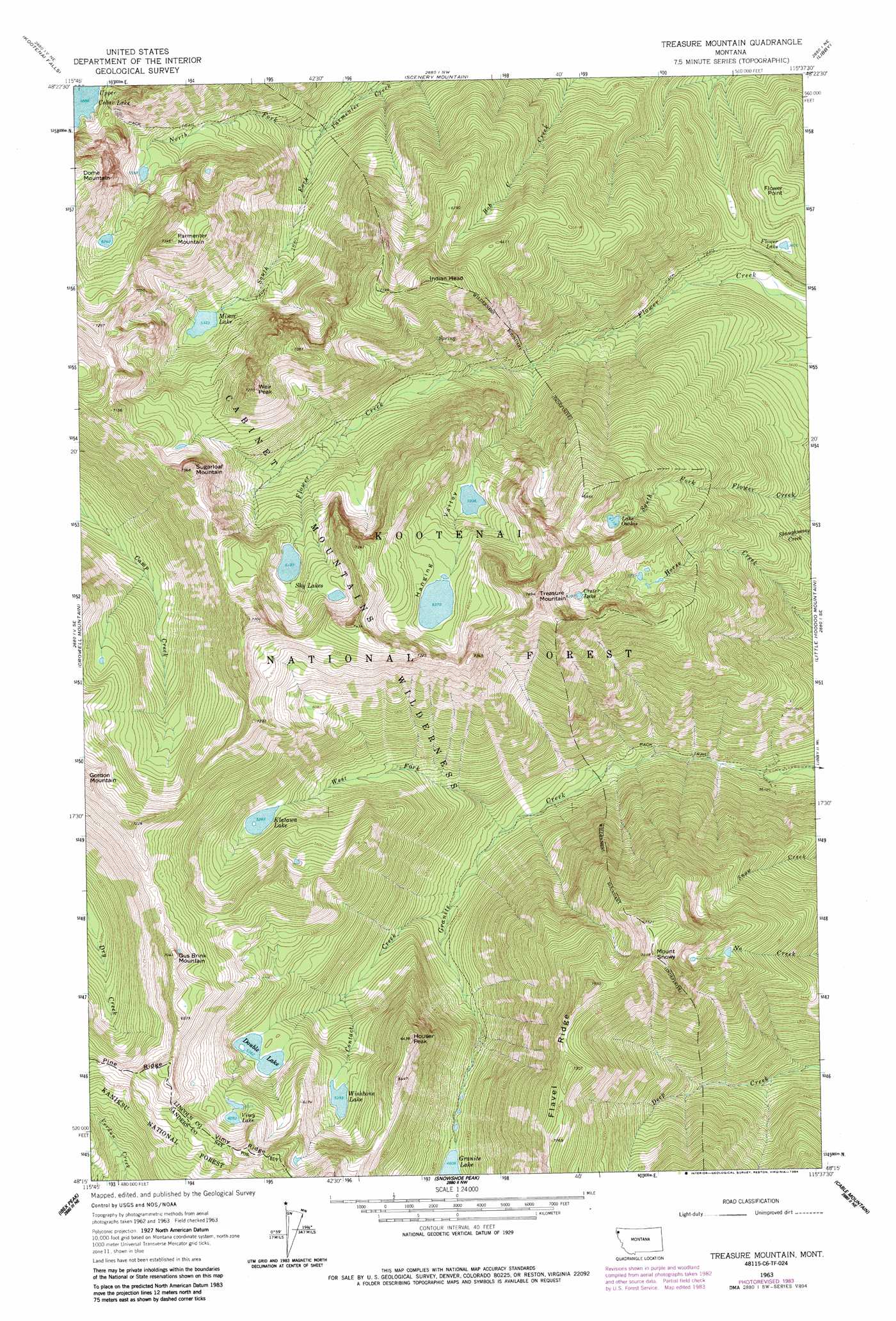
USGS Topo Quad 48115c6 - 1:24,000 scale
| Topo Map Name: | Treasure Mountain |
| USGS Topo Quad ID: | 48115c6 |
| Print Size: | ca. 21 1/4" wide x 27" high |
| Southeast Coordinates: | 48.25° N latitude / 115.625° W longitude |
| Map Center Coordinates: | 48.3125° N latitude / 115.6875° W longitude |
| U.S. State: | MT |
| Filename: | o48115c6.jpg |
| Download Map JPG Image: | Treasure Mountain topo map 1:24,000 scale |
| Map Type: | Topographic |
| Topo Series: | 7.5´ |
| Map Scale: | 1:24,000 |
| Source of Map Images: | United States Geological Survey (USGS) |
| Alternate Map Versions: |
Treasure Mountain MT 1963, updated 1966 Download PDF Buy paper map Treasure Mountain MT 1963, updated 1984 Download PDF Buy paper map Treasure Mountain MT 1997, updated 2000 Download PDF Buy paper map Treasure Mountain MT 2011 Download PDF Buy paper map Treasure Mountain MT 2014 Download PDF Buy paper map |
| FStopo: | US Forest Service topo Treasure Mountain is available: Download FStopo PDF Download FStopo TIF |
1:24,000 Topo Quads surrounding Treasure Mountain
Kilbrennan Lake |
Pulpit Mountain |
Turner Mountain |
Gold Hill |
Banfield Mountain |
Troy |
Kootenai Falls |
Scenery Mountain |
Libby |
Vermiculite Mountain |
Spar Lake |
Crowell Mountain |
Treasure Mountain |
Little Hoodo Mountain |
Swede Mountain |
Sawtooth Mountain |
Ibex Peak |
Snowshoe Peak |
Cable Mountain |
Horse Mountain |
Heron |
Smeads Bench |
Elephant Peak |
Howard Lake |
Barren Peak |
> Back to 48115a1 at 1:100,000 scale
> Back to 48114a1 at 1:250,000 scale
> Back to U.S. Topo Maps home
Treasure Mountain topo map: Gazetteer
Treasure Mountain: Basins
Hanging Valley elevation 1931m 6335′Treasure Mountain: Lakes
Crater Lake elevation 1950m 6397′Double Lake elevation 1636m 5367′
Flower Lake elevation 1167m 3828′
Klatawa Lake elevation 1613m 5291′
Lake Osakis elevation 1866m 6122′
Minor Lake elevation 1624m 5328′
Sky Lakes elevation 1890m 6200′
Vimy Lake elevation 1846m 6056′
Wishbone Lake elevation 1645m 5396′
Treasure Mountain: Mines
Silver Mountain Mine elevation 1000m 3280′Victor-Empire Mine elevation 1034m 3392′
Treasure Mountain: Ridges
Flavel Ridge elevation 2199m 7214′Treasure Mountain: Streams
Contact Creek elevation 1176m 3858′North Fork Parmenter Creek elevation 1242m 4074′
South Fork Parmenter Creek elevation 1238m 4061′
West Fork Granite Creek elevation 1121m 3677′
Treasure Mountain: Summits
Flower Point elevation 1304m 4278′Gus Brink Mountain elevation 2149m 7050′
Houser Peak elevation 1956m 6417′
Indian Head elevation 2208m 7244′
Mount Snowy elevation 2321m 7614′
Parmenter Mountain elevation 2226m 7303′
Sugarloaf Mountain elevation 2283m 7490′
Treasure Mountain elevation 2338m 7670′
Weir Peak elevation 2211m 7253′
Treasure Mountain digital topo map on disk
Buy this Treasure Mountain topo map showing relief, roads, GPS coordinates and other geographical features, as a high-resolution digital map file on DVD: