Volcour Topo Map Montana
To zoom in, hover over the map of Volcour
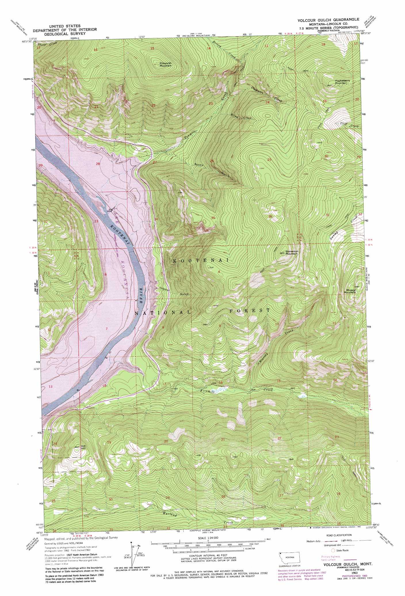
USGS Topo Quad 48115e2 - 1:24,000 scale
| Topo Map Name: | Volcour |
| USGS Topo Quad ID: | 48115e2 |
| Print Size: | ca. 21 1/4" wide x 27" high |
| Southeast Coordinates: | 48.5° N latitude / 115.125° W longitude |
| Map Center Coordinates: | 48.5625° N latitude / 115.1875° W longitude |
| U.S. State: | MT |
| Filename: | o48115e2.jpg |
| Download Map JPG Image: | Volcour topo map 1:24,000 scale |
| Map Type: | Topographic |
| Topo Series: | 7.5´ |
| Map Scale: | 1:24,000 |
| Source of Map Images: | United States Geological Survey (USGS) |
| Alternate Map Versions: |
Volcour MT 1963, updated 1966 Download PDF Buy paper map Volcour Gulch MT 1983, updated 1984 Download PDF Buy paper map Volcour Gulch MT 1997, updated 2000 Download PDF Buy paper map Volcour Gulch MT 2011 Download PDF Buy paper map Volcour Gulch MT 2014 Download PDF Buy paper map |
| FStopo: | US Forest Service topo Volcour Gulch is available: Download FStopo PDF Download FStopo TIF |
1:24,000 Topo Quads surrounding Volcour
Boulder Lakes |
Webb Mountain |
Beartrap Mountain |
Eureka South |
Fortine |
Parsnip Mountain |
Inch Mountain |
Mcguire Mountain |
Pinkham Mountain |
Edna Mountain |
Banfield Mountain |
Ural |
Volcour |
Davis Mountain |
Skillet Mountain |
Vermiculite Mountain |
Alexander Mountain |
Cripple Horse Mountain |
Warland Peak |
Bowen Lake |
Swede Mountain |
Tony Peak |
Richards Mountain |
Wolf Prairie |
Horse Hill |
> Back to 48115e1 at 1:100,000 scale
> Back to 48114a1 at 1:250,000 scale
> Back to U.S. Topo Maps home
Volcour topo map: Gazetteer
Volcour: Falls
Tenmile Falls elevation 1232m 4041′Volcour: Populated Places
Volcour (historical) elevation 751m 2463′Volcour: Streams
Blind Creek elevation 928m 3044′Bluesky Creek elevation 791m 2595′
Briery Creek elevation 1263m 4143′
Clematis Creek elevation 966m 3169′
Fivemile Creek elevation 751m 2463′
Tenmile Creek elevation 751m 2463′
Volcour: Summits
Ant Hill elevation 1165m 3822′Ellsworth Mountain elevation 1796m 5892′
Huckleberry Mountain elevation 1845m 6053′
Mineral Mountain elevation 1700m 5577′
Stenerson Mountain elevation 1773m 5816′
Volcour: Valleys
Rocky Gulch elevation 796m 2611′Volcour Gulch elevation 751m 2463′
Volcour digital topo map on disk
Buy this Volcour topo map showing relief, roads, GPS coordinates and other geographical features, as a high-resolution digital map file on DVD: