Talache Topo Map Idaho
To zoom in, hover over the map of Talache
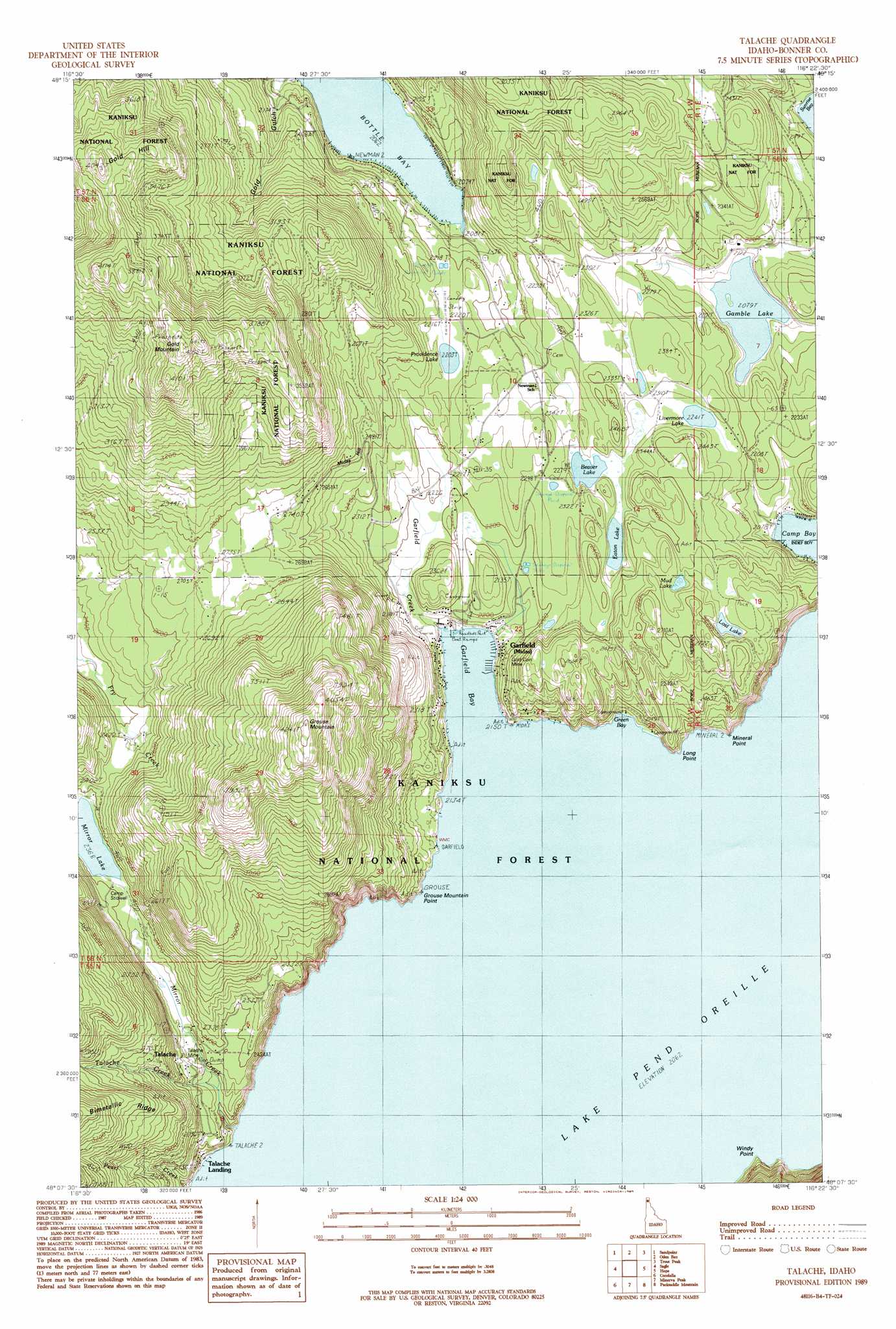
USGS Topo Quad 48116b4 - 1:24,000 scale
| Topo Map Name: | Talache |
| USGS Topo Quad ID: | 48116b4 |
| Print Size: | ca. 21 1/4" wide x 27" high |
| Southeast Coordinates: | 48.125° N latitude / 116.375° W longitude |
| Map Center Coordinates: | 48.1875° N latitude / 116.4375° W longitude |
| U.S. State: | ID |
| Filename: | o48116b4.jpg |
| Download Map JPG Image: | Talache topo map 1:24,000 scale |
| Map Type: | Topographic |
| Topo Series: | 7.5´ |
| Map Scale: | 1:24,000 |
| Source of Map Images: | United States Geological Survey (USGS) |
| Alternate Map Versions: |
Talache ID 1989, updated 1989 Download PDF Buy paper map Talache ID 1996, updated 1999 Download PDF Buy paper map Talache ID 2011 Download PDF Buy paper map Talache ID 2013 Download PDF Buy paper map |
| FStopo: | US Forest Service topo Talache is available: Download FStopo PDF Download FStopo TIF |
1:24,000 Topo Quads surrounding Talache
Mount Casey |
Colburn |
Elmira |
Wylie Knob |
Mount Pend Oreille |
Happy Fork Gap |
Sandpoint |
Oden Bay |
Trout Peak |
Trestle Peak |
Morton |
Sagle |
Talache |
Hope |
Clark Fork |
Careywood |
Cocolalla |
Minerva Peak |
Packsaddle Mountain |
Derr Point |
Athol |
Bayview |
Lakeview |
Faset Peak |
Cathedral Peak |
> Back to 48116a1 at 1:100,000 scale
> Back to 48116a1 at 1:250,000 scale
> Back to U.S. Topo Maps home
Talache topo map: Gazetteer
Talache: Airports
Bird Number Two Airport elevation 710m 2329′Timber Basin Ranch Airport elevation 680m 2230′
Talache: Bays
Bottle Bay elevation 630m 2066′Garfield Bay elevation 630m 2066′
Green Bay elevation 630m 2066′
Talache: Capes
Anderson Point elevation 644m 2112′Grouse Mountain Point elevation 651m 2135′
Long Point elevation 656m 2152′
Mineral Point elevation 630m 2066′
Windy Point elevation 630m 2066′
Talache: Lakes
Beaver Lake elevation 688m 2257′Eaton Lake elevation 688m 2257′
Gamlin Lake elevation 635m 2083′
Livermore Lake elevation 684m 2244′
Lost Lake elevation 753m 2470′
Mud Lake elevation 747m 2450′
Providence Lake elevation 673m 2208′
Talache: Mines
Gold Coin Mine elevation 694m 2276′Portland Group Mine elevation 796m 2611′
Talache Mine elevation 703m 2306′
Talache: Populated Places
Broten elevation 719m 2358′Garfield elevation 652m 2139′
Newman elevation 700m 2296′
Talache elevation 743m 2437′
Talache Landing elevation 630m 2066′
Talache: Post Offices
Broten Post Office (historical) elevation 719m 2358′Talache: Streams
Garfield Creek elevation 630m 2066′Mirror Creek elevation 630m 2066′
Pearl Creek elevation 635m 2083′
Talache Creek elevation 682m 2237′
Talache: Summits
Gold Hill elevation 1230m 4035′Gold Mountain elevation 1274m 4179′
Grouse Mountain elevation 1289m 4229′
Talache digital topo map on disk
Buy this Talache topo map showing relief, roads, GPS coordinates and other geographical features, as a high-resolution digital map file on DVD: