Outlet Bay Topo Map Idaho
To zoom in, hover over the map of Outlet Bay
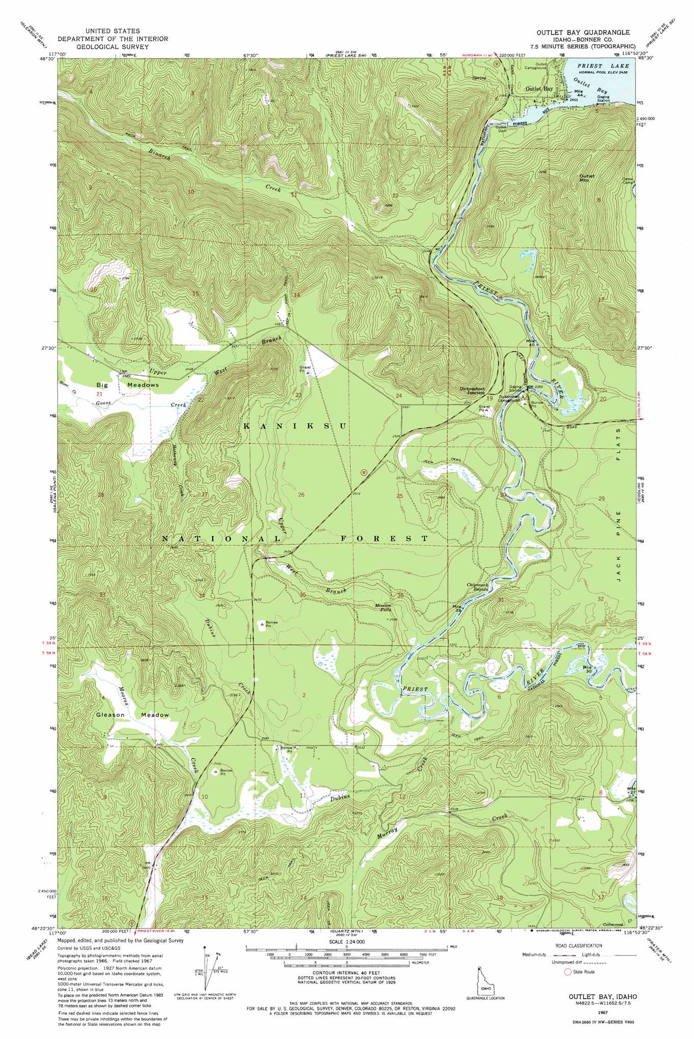
USGS Topo Quad 48116d8 - 1:24,000 scale
| Topo Map Name: | Outlet Bay |
| USGS Topo Quad ID: | 48116d8 |
| Print Size: | ca. 21 1/4" wide x 27" high |
| Southeast Coordinates: | 48.375° N latitude / 116.875° W longitude |
| Map Center Coordinates: | 48.4375° N latitude / 116.9375° W longitude |
| U.S. State: | ID |
| Filename: | o48116d8.jpg |
| Download Map JPG Image: | Outlet Bay topo map 1:24,000 scale |
| Map Type: | Topographic |
| Topo Series: | 7.5´ |
| Map Scale: | 1:24,000 |
| Source of Map Images: | United States Geological Survey (USGS) |
| Alternate Map Versions: |
Outlet Bay ID 1967, updated 1971 Download PDF Buy paper map Outlet Bay ID 1967, updated 1983 Download PDF Buy paper map Outlet Bay ID 1967, updated 1983 Download PDF Buy paper map Outlet Bay ID 1996, updated 1999 Download PDF Buy paper map Outlet Bay ID 2011 Download PDF Buy paper map Outlet Bay ID 2013 Download PDF Buy paper map |
| FStopo: | US Forest Service topo Outlet Bay is available: Download FStopo PDF Download FStopo TIF |
1:24,000 Topo Quads surrounding Outlet Bay
Monumental Mountain |
Orwig Hump |
Priest Lake Nw |
Priest Lake Ne |
The Wigwams |
North Baldy |
Gleason Mountain |
Priest Lake Sw |
Priest Lake Se |
Mount Roothaan |
Browns Lake |
Galena Point |
Outlet Bay |
Coolin |
Mount Casey |
Skookum Creek |
Bead Lake |
Quartz Mountain |
Prater Mountain |
Happy Fork Gap |
Diamond Lake |
Newport |
Priest River |
Laclede |
Morton |
> Back to 48116a1 at 1:100,000 scale
> Back to 48116a1 at 1:250,000 scale
> Back to U.S. Topo Maps home
Outlet Bay topo map: Gazetteer
Outlet Bay: Bays
Outlet Bay elevation 744m 2440′Outlet Bay: Dams
Outlet Dam elevation 745m 2444′Priest Lake Dam elevation 744m 2440′
Outlet Bay: Falls
Mission Falls elevation 708m 2322′Outlet Bay: Flats
Gleason Meadow elevation 754m 2473′Outlet Bay: Parks
Kaniksu Marsh Research Natural Area elevation 739m 2424′Outlet Bay: Populated Places
Dickensheet Junction elevation 777m 2549′Outlet Bay elevation 754m 2473′
Outlet Bay: Rapids
Chipmunk Rapids elevation 703m 2306′Outlet Bay: Reservoirs
Priest Lake elevation 744m 2440′Outlet Bay: Streams
Binarch Creek elevation 739m 2424′Binarch Creek elevation 739m 2424′
Blonc Creek elevation 760m 2493′
Cottonwood Creek elevation 688m 2257′
Dubius Creek elevation 696m 2283′
Goose Creek elevation 752m 2467′
Goose Creek elevation 752m 2467′
Hathaway Creek elevation 754m 2473′
Lamb Creek elevation 744m 2440′
Lamb Creek elevation 744m 2440′
Murray Creek elevation 688m 2257′
Upper West Branch Priest River elevation 701m 2299′
Upper West Branch Priest River elevation 701m 2299′
Outlet Bay: Summits
Outlet Mountain elevation 1067m 3500′Outlet Bay: Trails
Chipmunk Rapids National Recreation Trail elevation 766m 2513′Outlet Bay digital topo map on disk
Buy this Outlet Bay topo map showing relief, roads, GPS coordinates and other geographical features, as a high-resolution digital map file on DVD: