Caribou Creek Topo Map Idaho
To zoom in, hover over the map of Caribou Creek
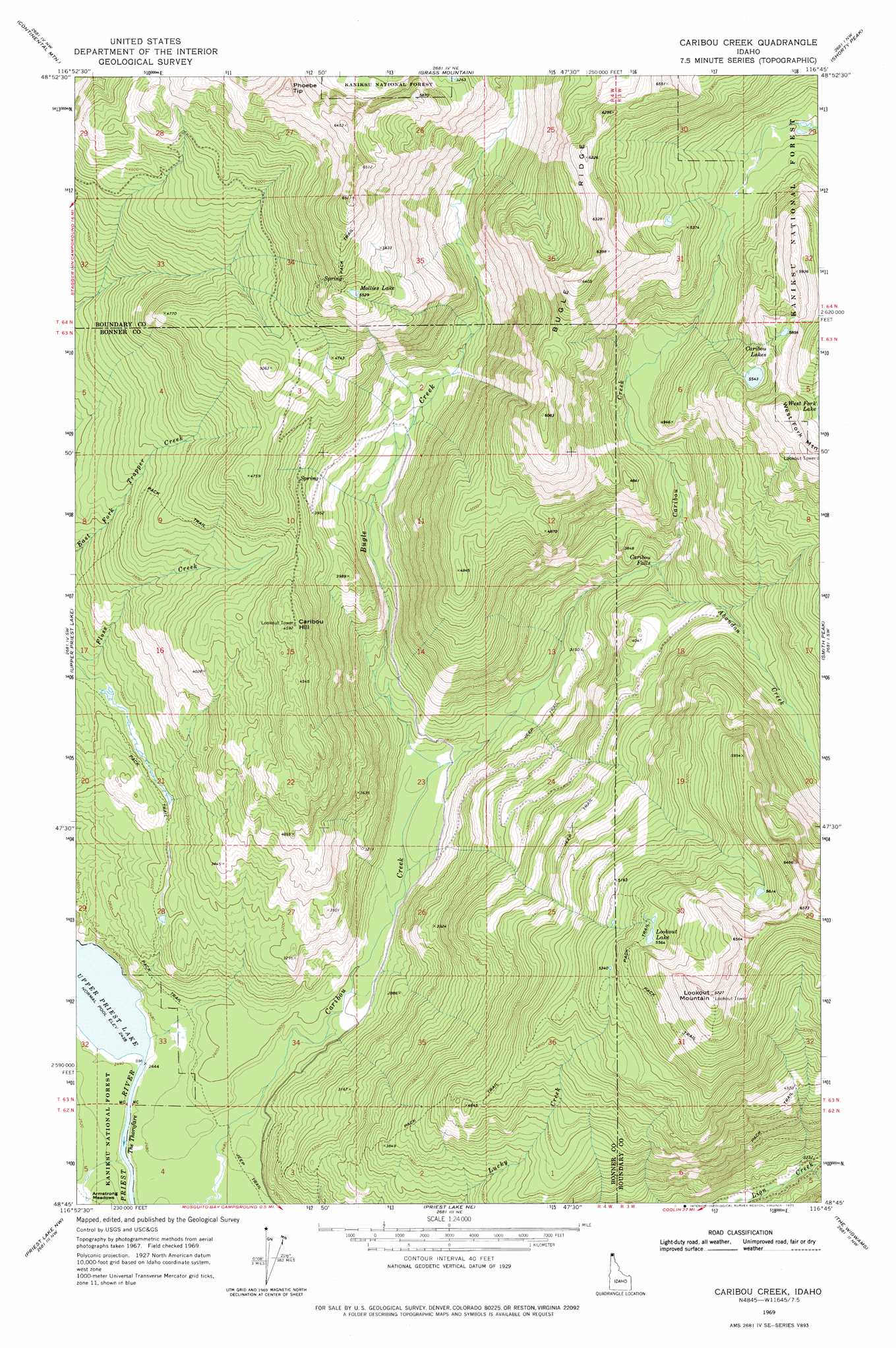
USGS Topo Quad 48116g7 - 1:24,000 scale
| Topo Map Name: | Caribou Creek |
| USGS Topo Quad ID: | 48116g7 |
| Print Size: | ca. 21 1/4" wide x 27" high |
| Southeast Coordinates: | 48.75° N latitude / 116.75° W longitude |
| Map Center Coordinates: | 48.8125° N latitude / 116.8125° W longitude |
| U.S. State: | ID |
| Filename: | o48116g7.jpg |
| Download Map JPG Image: | Caribou Creek topo map 1:24,000 scale |
| Map Type: | Topographic |
| Topo Series: | 7.5´ |
| Map Scale: | 1:24,000 |
| Source of Map Images: | United States Geological Survey (USGS) |
| Alternate Map Versions: |
Caribou Creek ID 1969, updated 1971 Download PDF Buy paper map Caribou Creek ID 1969, updated 1975 Download PDF Buy paper map Caribou Creek ID 1996, updated 1999 Download PDF Buy paper map Caribou Creek ID 2011 Download PDF Buy paper map Caribou Creek ID 2013 Download PDF Buy paper map |
| FStopo: | US Forest Service topo Caribou Creek is available: Download FStopo PDF Download FStopo TIF |
1:24,000 Topo Quads surrounding Caribou Creek
Salmo Mountain |
Continental Mountain |
Grass Mountain |
Shorty Peak |
Smith Falls |
Helmer Mountain |
Upper Priest Lake |
Caribou Creek |
Smith Peak |
Pyramid Peak |
Orwig Hump |
Priest Lake Nw |
Priest Lake Ne |
The Wigwams |
Roman Nose |
Gleason Mountain |
Priest Lake Sw |
Priest Lake Se |
Mount Roothaan |
Dodge Peak |
> Back to 48116e1 at 1:100,000 scale
> Back to 48116a1 at 1:250,000 scale
> Back to U.S. Topo Maps home
Caribou Creek topo map: Gazetteer
Caribou Creek: Falls
Caribou Falls elevation 1051m 3448′Caribou Creek: Flats
Armstrong Meadows elevation 767m 2516′Caribou Creek: Lakes
Caribou Lakes elevation 1691m 5547′Lookout Lake elevation 1703m 5587′
Mollies Lake elevation 1689m 5541′
Caribou Creek: Ridges
Bugle Ridge elevation 1953m 6407′Caribou Creek: Streams
Abandon Creek elevation 1055m 3461′Bugle Creek elevation 824m 2703′
Caribou Creek: Summits
Caribou Hill elevation 1398m 4586′Lookout Mountain elevation 2049m 6722′
Phoebe Tip elevation 2016m 6614′
Caribou Creek digital topo map on disk
Buy this Caribou Creek topo map showing relief, roads, GPS coordinates and other geographical features, as a high-resolution digital map file on DVD: