Chewelah Topo Map Washington
To zoom in, hover over the map of Chewelah
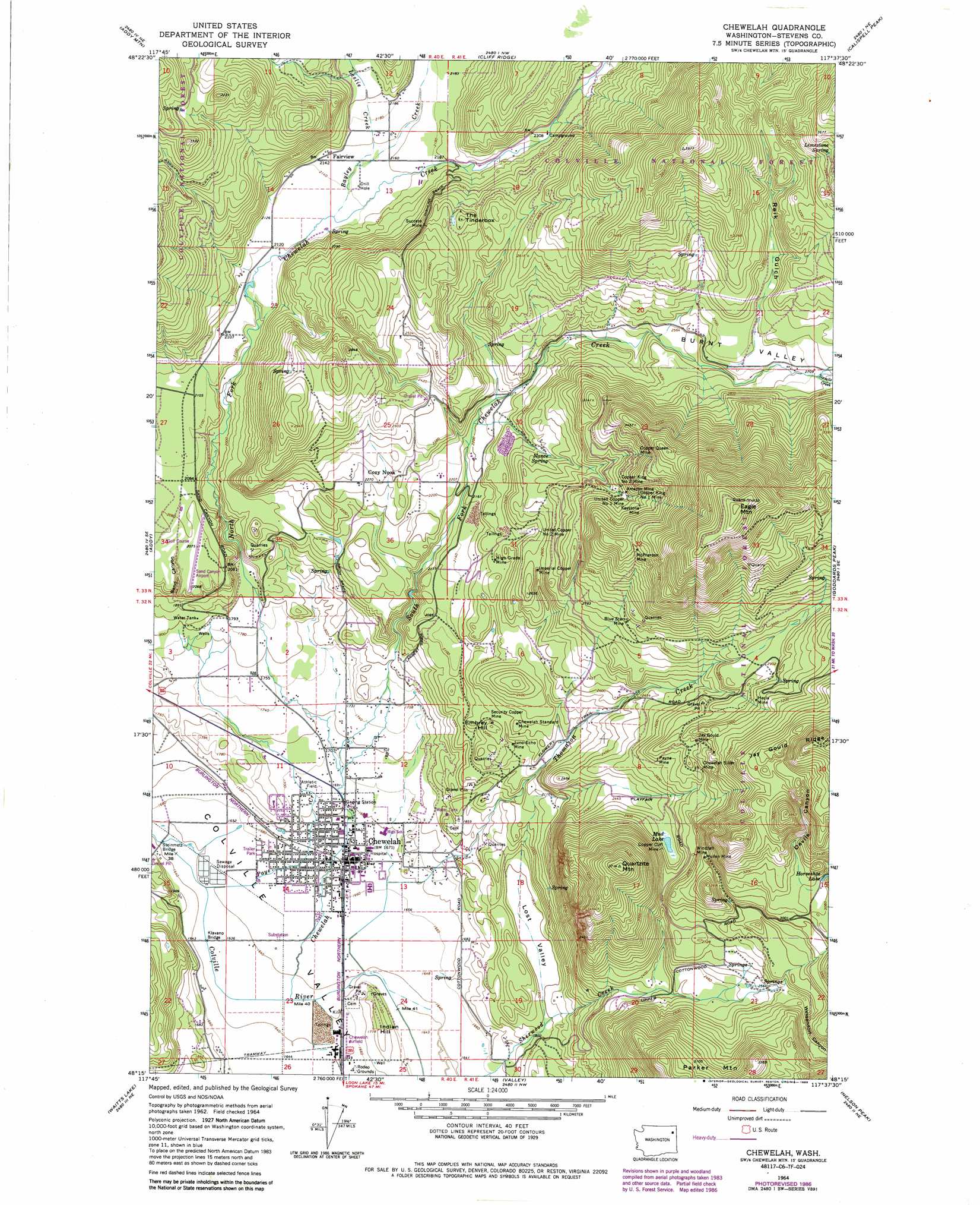
USGS Topo Quad 48117c6 - 1:24,000 scale
| Topo Map Name: | Chewelah |
| USGS Topo Quad ID: | 48117c6 |
| Print Size: | ca. 21 1/4" wide x 27" high |
| Southeast Coordinates: | 48.25° N latitude / 117.625° W longitude |
| Map Center Coordinates: | 48.3125° N latitude / 117.6875° W longitude |
| U.S. State: | WA |
| Filename: | o48117c6.jpg |
| Download Map JPG Image: | Chewelah topo map 1:24,000 scale |
| Map Type: | Topographic |
| Topo Series: | 7.5´ |
| Map Scale: | 1:24,000 |
| Source of Map Images: | United States Geological Survey (USGS) |
| Alternate Map Versions: |
Chewelah WA 1964, updated 1965 Download PDF Buy paper map Chewelah WA 1964, updated 1973 Download PDF Buy paper map Chewelah WA 1964, updated 1981 Download PDF Buy paper map Chewelah WA 1964, updated 1986 Download PDF Buy paper map Chewelah WA 1992, updated 1996 Download PDF Buy paper map Chewelah WA 2011 Download PDF Buy paper map Chewelah WA 2014 Download PDF Buy paper map |
| FStopo: | US Forest Service topo Chewelah is available: Download FStopo PDF Download FStopo TIF |
1:24,000 Topo Quads surrounding Chewelah
Colville |
White Mud Lake |
Park Rapids |
Lake Gillette |
Timber Mountain |
Arden |
Addy Mountain |
Cliff Ridge |
Calispell Peak |
Tacoma Peak |
Dunn Mountain |
Addy |
Chewelah |
Goddards Peak |
Winchester Peak |
Stensgar Mountain |
Waitts Lake |
Valley |
Nelson Peak |
Boyer Mountain |
Empey Mountain |
Forest Center |
Springdale |
Deer Lake |
Fan Lake |
> Back to 48117a1 at 1:100,000 scale
> Back to 48116a1 at 1:250,000 scale
> Back to U.S. Topo Maps home
Chewelah topo map: Gazetteer
Chewelah: Airports
Chewelah Airfield elevation 505m 1656′Saint Josephs Hospital Airport elevation 529m 1735′
Sand Canyon Airport elevation 633m 2076′
Chewelah: Bridges
Klavano Bridge elevation 498m 1633′Steinmetz Bridge elevation 498m 1633′
Chewelah: Lakes
Mud Lake elevation 764m 2506′Chewelah: Mines
Amazon Mine elevation 901m 2956′Blue Star Mine elevation 878m 2880′
Chewelah Silver Mine elevation 844m 2769′
Chewelah Standard Mine elevation 686m 2250′
Copper Cliff Mine elevation 784m 2572′
Copper King Number 2 Mine elevation 895m 2936′
Copper Queen Mine elevation 968m 3175′
Hecla Mine elevation 912m 2992′
High Grade Mine elevation 714m 2342′
Imperial Copper Mine elevation 774m 2539′
Jay Gould Mine elevation 866m 2841′
Juno-Echo Mine elevation 649m 2129′
Keystone Mine elevation 934m 3064′
McPherson Mine elevation 1035m 3395′
Mullen Mine elevation 903m 2962′
Payne Mine elevation 825m 2706′
Security Copper Mine elevation 678m 2224′
Success Mine elevation 794m 2604′
United Copper Number 1 Mine elevation 889m 2916′
United Copper Number 2 Mine elevation 760m 2493′
Windfall Mine elevation 833m 2732′
Chewelah: Parks
Chewelah City Park elevation 512m 1679′Chewelah: Populated Places
Chewelah elevation 508m 1666′Cozy Nook elevation 701m 2299′
Fairview elevation 656m 2152′
Chewelah: Springs
Limestone Spring elevation 1067m 3500′Nance Spring elevation 767m 2516′
Chewelah: Streams
Bayley Creek elevation 650m 2132′Chewelah Creek elevation 500m 1640′
Leslie Creek elevation 654m 2145′
North Fork Chewelah Creek elevation 518m 1699′
Paye Creek elevation 500m 1640′
Sixmile Creek elevation 826m 2709′
South Fork Chewelah Creek elevation 518m 1699′
Thomason Creek elevation 501m 1643′
Chewelah: Summits
Eagle Mountain elevation 1407m 4616′Embrey Hill elevation 691m 2267′
Indian Hill elevation 540m 1771′
Quartzite Mountain elevation 1126m 3694′
The Tinderbox elevation 821m 2693′
Chewelah: Valleys
Burnt Valley elevation 721m 2365′Devils Canyon elevation 949m 3113′
Lost Valley elevation 546m 1791′
Reik Gulch elevation 817m 2680′
Sand Canyon elevation 599m 1965′
Chewelah digital topo map on disk
Buy this Chewelah topo map showing relief, roads, GPS coordinates and other geographical features, as a high-resolution digital map file on DVD: