Aladdin Mountain Topo Map Washington
To zoom in, hover over the map of Aladdin Mountain
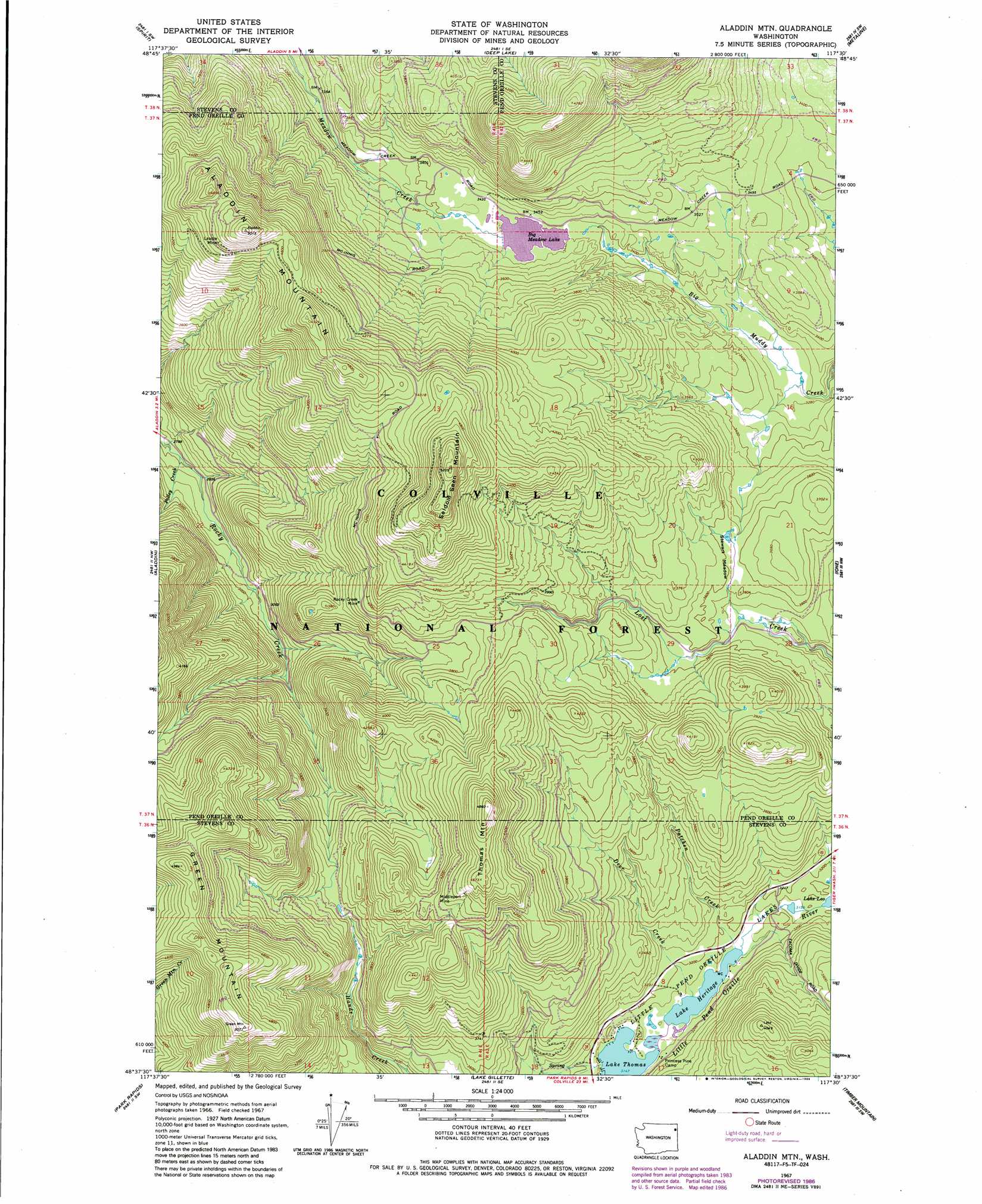
USGS Topo Quad 48117f5 - 1:24,000 scale
| Topo Map Name: | Aladdin Mountain |
| USGS Topo Quad ID: | 48117f5 |
| Print Size: | ca. 21 1/4" wide x 27" high |
| Southeast Coordinates: | 48.625° N latitude / 117.5° W longitude |
| Map Center Coordinates: | 48.6875° N latitude / 117.5625° W longitude |
| U.S. State: | WA |
| Filename: | o48117f5.jpg |
| Download Map JPG Image: | Aladdin Mountain topo map 1:24,000 scale |
| Map Type: | Topographic |
| Topo Series: | 7.5´ |
| Map Scale: | 1:24,000 |
| Source of Map Images: | United States Geological Survey (USGS) |
| Alternate Map Versions: |
Aladdin Mtn WA 1967, updated 1969 Download PDF Buy paper map Aladdin Mtn WA 1967, updated 1980 Download PDF Buy paper map Aladdin Mtn WA 1967, updated 1982 Download PDF Buy paper map Aladdin Mtn WA 1967, updated 1986 Download PDF Buy paper map Aladdin Mtn WA 1992, updated 1996 Download PDF Buy paper map Aladdin Mountain WA 2011 Download PDF Buy paper map Aladdin Mountain WA 2014 Download PDF Buy paper map |
| FStopo: | US Forest Service topo Aladdin Mountain is available: Download FStopo PDF Download FStopo TIF |
1:24,000 Topo Quads surrounding Aladdin Mountain
Northport |
Boundary |
Leadpoint |
Abercrombie Mountain |
Boundary Dam |
Onion Creek |
Spirit |
Deep Lake |
Metaline |
Metaline Falls |
Gillette Mountain |
Aladdin |
Aladdin Mountain |
Ione |
Scotchman Lake |
White Mud Lake |
Park Rapids |
Lake Gillette |
Timber Mountain |
Ruby |
Addy Mountain |
Cliff Ridge |
Calispell Peak |
Tacoma Peak |
Jared |
> Back to 48117e1 at 1:100,000 scale
> Back to 48116a1 at 1:250,000 scale
> Back to U.S. Topo Maps home
Aladdin Mountain topo map: Gazetteer
Aladdin Mountain: Dams
Heather Lake Dam elevation 1044m 3425′Aladdin Mountain: Flats
Hills Meadow elevation 1187m 3894′Stewart Meadow elevation 1095m 3592′
Aladdin Mountain: Lakes
Lake Heritage elevation 961m 3152′Lake Thomas elevation 960m 3149′
Little Pend Oreille Lakes elevation 960m 3149′
Aladdin Mountain: Mines
Lasota Mine elevation 1419m 4655′Middleport Mine elevation 1344m 4409′
Rocky Creek Mine elevation 1196m 3923′
Aladdin Mountain: Reservoirs
Big Meadow Lake elevation 1044m 3425′Aladdin Mountain: Streams
Deer Creek elevation 962m 3156′Patchen Creek elevation 961m 3152′
Polley Creek elevation 853m 2798′
Aladdin Mountain: Summits
Aladdin Mountain elevation 1529m 5016′Green Mountain elevation 1517m 4977′
Seldom Seen Mountain elevation 1577m 5173′
Thomas Mountain elevation 1420m 4658′
Aladdin Mountain digital topo map on disk
Buy this Aladdin Mountain topo map showing relief, roads, GPS coordinates and other geographical features, as a high-resolution digital map file on DVD: