Gillette Mountain Topo Map Washington
To zoom in, hover over the map of Gillette Mountain
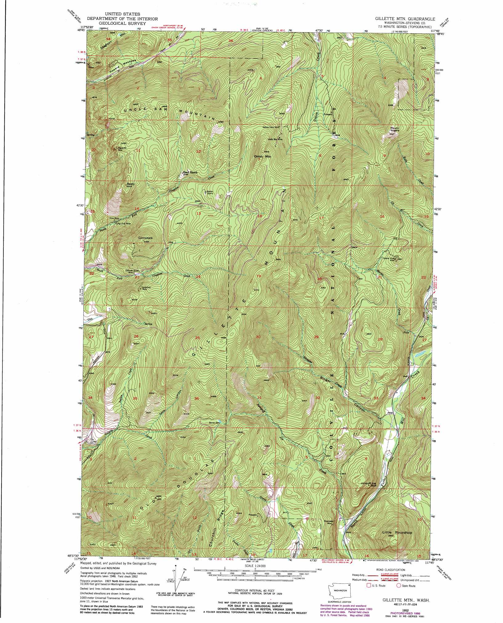
USGS Topo Quad 48117f7 - 1:24,000 scale
| Topo Map Name: | Gillette Mountain |
| USGS Topo Quad ID: | 48117f7 |
| Print Size: | ca. 21 1/4" wide x 27" high |
| Southeast Coordinates: | 48.625° N latitude / 117.75° W longitude |
| Map Center Coordinates: | 48.6875° N latitude / 117.8125° W longitude |
| U.S. State: | WA |
| Filename: | o48117f7.jpg |
| Download Map JPG Image: | Gillette Mountain topo map 1:24,000 scale |
| Map Type: | Topographic |
| Topo Series: | 7.5´ |
| Map Scale: | 1:24,000 |
| Source of Map Images: | United States Geological Survey (USGS) |
| Alternate Map Versions: |
Gillette Mtn WA 1952, updated 1953 Download PDF Buy paper map Gillette Mtn WA 1952, updated 1972 Download PDF Buy paper map Gillette Mtn WA 1952, updated 1986 Download PDF Buy paper map Gillette Mtn WA 1992, updated 1996 Download PDF Buy paper map Gillette Mountain WA 2011 Download PDF Buy paper map Gillette Mountain WA 2014 Download PDF Buy paper map |
| FStopo: | US Forest Service topo Gillette Mountain is available: Download FStopo PDF Download FStopo TIF |
1:24,000 Topo Quads surrounding Gillette Mountain
Churchill Mountain |
Belshazzar Mountain |
Northport |
Boundary |
Leadpoint |
Bossburg |
China Bend |
Onion Creek |
Spirit |
Deep Lake |
Marcus |
Echo Valley |
Gillette Mountain |
Aladdin |
Aladdin Mountain |
Kettle Falls |
Colville |
White Mud Lake |
Park Rapids |
Lake Gillette |
Kentry Ridge |
Arden |
Addy Mountain |
Cliff Ridge |
Calispell Peak |
> Back to 48117e1 at 1:100,000 scale
> Back to 48116a1 at 1:250,000 scale
> Back to U.S. Topo Maps home
Gillette Mountain topo map: Gazetteer
Gillette Mountain: Cliffs
Jumpoff Joe Bluff elevation 921m 3021′Gillette Mountain: Flats
Howard Meadows elevation 901m 2956′Gillette Mountain: Mines
Big Chief Mine elevation 942m 3090′Chloride Queen Mine elevation 988m 3241′
Echo Mine elevation 914m 2998′
Galena Farm Mine elevation 1271m 4169′
Galena Knob Mine elevation 1197m 3927′
Lucky Boy Mine elevation 1270m 4166′
Marble Quarry elevation 1282m 4206′
Neglected Mine elevation 1275m 4183′
Shoemaker Mine elevation 799m 2621′
Tenderfoot Mine elevation 1185m 3887′
Gillette Mountain: Ridges
Churchill Ridge elevation 1302m 4271′Gillette Mountain: Streams
Indian Creek elevation 919m 3015′Jumpoff Joe Creek elevation 706m 2316′
Marble Creek elevation 760m 2493′
Strauss Creek elevation 743m 2437′
Gillette Mountain: Summits
Baldy elevation 1357m 4452′Comstock elevation 1313m 4307′
Gillette Mountain elevation 1757m 5764′
Green Mountain elevation 1662m 5452′
Little Roundtop elevation 1165m 3822′
Mount Rogers elevation 1657m 5436′
Old Douglas elevation 1579m 5180′
Onion Mountain elevation 1496m 4908′
Staghorn Mountain elevation 1146m 3759′
Uncle Sam Mountain elevation 1417m 4648′
Gillette Mountain: Valleys
Binger Canyon elevation 777m 2549′Davis Canyon elevation 1018m 3339′
Gillette Mountain digital topo map on disk
Buy this Gillette Mountain topo map showing relief, roads, GPS coordinates and other geographical features, as a high-resolution digital map file on DVD: