Echo Valley Topo Map Washington
To zoom in, hover over the map of Echo Valley
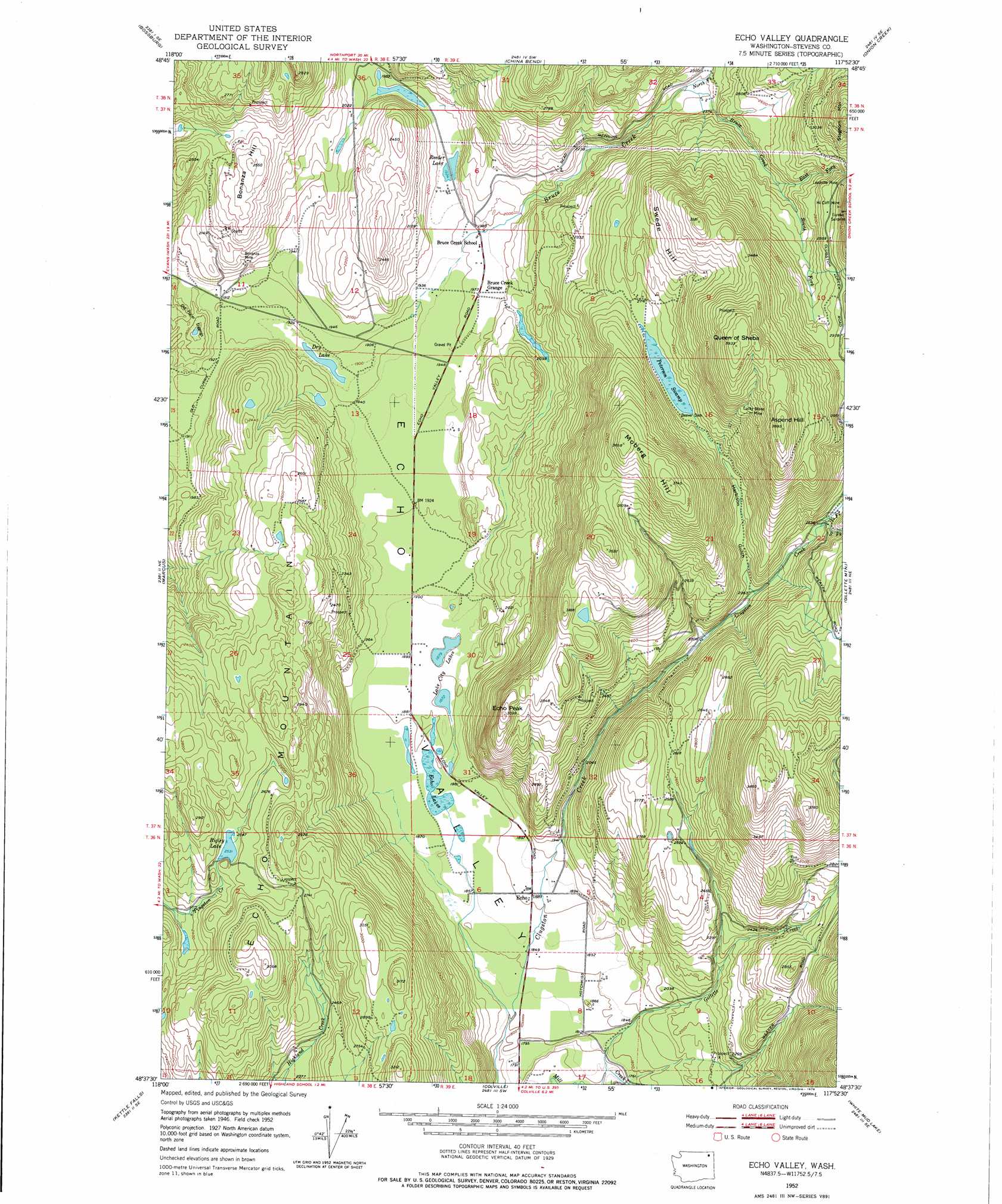
USGS Topo Quad 48117f8 - 1:24,000 scale
| Topo Map Name: | Echo Valley |
| USGS Topo Quad ID: | 48117f8 |
| Print Size: | ca. 21 1/4" wide x 27" high |
| Southeast Coordinates: | 48.625° N latitude / 117.875° W longitude |
| Map Center Coordinates: | 48.6875° N latitude / 117.9375° W longitude |
| U.S. State: | WA |
| Filename: | o48117f8.jpg |
| Download Map JPG Image: | Echo Valley topo map 1:24,000 scale |
| Map Type: | Topographic |
| Topo Series: | 7.5´ |
| Map Scale: | 1:24,000 |
| Source of Map Images: | United States Geological Survey (USGS) |
| Alternate Map Versions: |
Echo Valley WA 1952, updated 1953 Download PDF Buy paper map Echo Valley WA 1952, updated 1976 Download PDF Buy paper map Echo Valley WA 1952, updated 1976 Download PDF Buy paper map Echo Valley WA 2011 Download PDF Buy paper map Echo Valley WA 2014 Download PDF Buy paper map |
1:24,000 Topo Quads surrounding Echo Valley
Laurier |
Churchill Mountain |
Belshazzar Mountain |
Northport |
Boundary |
Orient |
Bossburg |
China Bend |
Onion Creek |
Spirit |
Boyds |
Marcus |
Echo Valley |
Gillette Mountain |
Aladdin |
Bangs Mountain |
Kettle Falls |
Colville |
White Mud Lake |
Park Rapids |
Rice |
Kentry Ridge |
Arden |
Addy Mountain |
Cliff Ridge |
> Back to 48117e1 at 1:100,000 scale
> Back to 48116a1 at 1:250,000 scale
> Back to U.S. Topo Maps home
Echo Valley topo map: Gazetteer
Echo Valley: Lakes
Dry Lake elevation 576m 1889′Lake City Lakes elevation 575m 1886′
Reeder Lake elevation 588m 1929′
Rigley Lake elevation 773m 2536′
Echo Valley: Mines
Bonanza Mine elevation 632m 2073′Eureka Surprise elevation 1012m 3320′
Hill Cliff Mine elevation 937m 3074′
Leadville Mine elevation 930m 3051′
Lucky Stone Mine elevation 1016m 3333′
Old Placer Diggings elevation 546m 1791′
Echo Valley: Populated Places
Echo elevation 575m 1886′Echo Valley: Streams
Bruce Creek elevation 585m 1919′East Fork Bruce Creek elevation 759m 2490′
Gillette Creek elevation 532m 1745′
North Fork Bruce Creek elevation 683m 2240′
North Fork Clugston Creek elevation 780m 2559′
South Fork Bruce Creek elevation 759m 2490′
South Fork Clugston Creek elevation 779m 2555′
Echo Valley: Summits
Aspend Hill elevation 1184m 3884′Bonanza Hill elevation 771m 2529′
Echo Mountain elevation 931m 3054′
Echo Peak elevation 941m 3087′
Moberg Hill elevation 1139m 3736′
Queen of Sheba elevation 1199m 3933′
Swede Hill elevation 1091m 3579′
Echo Valley: Swamps
Peterson Swamp elevation 824m 2703′Echo Valley: Valleys
Echo Valley elevation 550m 1804′Harbison Gulch elevation 729m 2391′
Echo Valley digital topo map on disk
Buy this Echo Valley topo map showing relief, roads, GPS coordinates and other geographical features, as a high-resolution digital map file on DVD: