Gypsy Peak Topo Map Washington
To zoom in, hover over the map of Gypsy Peak
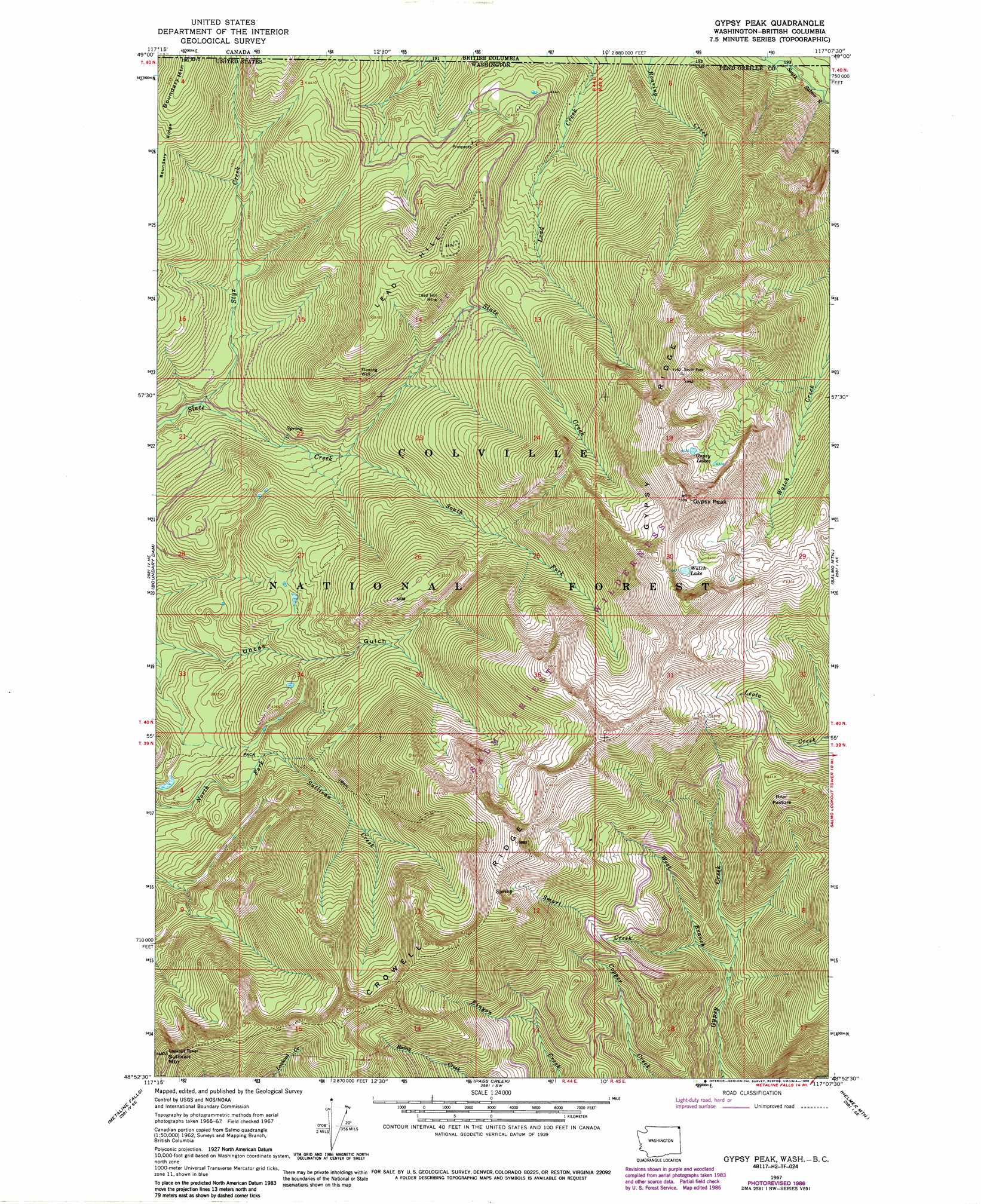
USGS Topo Quad 48117h2 - 1:24,000 scale
| Topo Map Name: | Gypsy Peak |
| USGS Topo Quad ID: | 48117h2 |
| Print Size: | ca. 21 1/4" wide x 27" high |
| Southeast Coordinates: | 48.875° N latitude / 117.125° W longitude |
| Map Center Coordinates: | 48.9375° N latitude / 117.1875° W longitude |
| U.S. State: | WA |
| Filename: | o48117h2.jpg |
| Download Map JPG Image: | Gypsy Peak topo map 1:24,000 scale |
| Map Type: | Topographic |
| Topo Series: | 7.5´ |
| Map Scale: | 1:24,000 |
| Source of Map Images: | United States Geological Survey (USGS) |
| Alternate Map Versions: |
Gypsy Peak WA 1967, updated 1971 Download PDF Buy paper map Gypsy Peak WA 1967, updated 1978 Download PDF Buy paper map Gypsy Peak WA 1967, updated 1986 Download PDF Buy paper map Gypsy Peak WA 1992, updated 1996 Download PDF Buy paper map Gypsy Peak WA 2011 Download PDF Buy paper map Gypsy Peak WA 2014 Download PDF Buy paper map |
| FStopo: | US Forest Service topo Gypsy Peak is available: Download FStopo PDF Download FStopo TIF |
1:24,000 Topo Quads surrounding Gypsy Peak
Abercrombie Mountain |
Boundary Dam |
Gypsy Peak |
Salmo Mountain |
Continental Mountain |
Metaline |
Metaline Falls |
Pass Creek |
Helmer Mountain |
Upper Priest Lake |
Ione |
Scotchman Lake |
Monumental Mountain |
Orwig Hump |
Priest Lake Nw |
> Back to 48117e1 at 1:100,000 scale
> Back to 48116a1 at 1:250,000 scale
> Back to U.S. Topo Maps home
Gypsy Peak topo map: Gazetteer
Gypsy Peak: Flats
Bear Pasture elevation 1650m 5413′Gypsy Peak: Lakes
Gypsy Lakes elevation 1932m 6338′Watch Lake elevation 1976m 6482′
Gypsy Peak: Mines
Lead Hill Mine elevation 1455m 4773′Gypsy Peak: Ridges
Crowell Ridge elevation 2038m 6686′Gypsy Ridge elevation 2148m 7047′
Gypsy Peak: Streams
Smart Creek elevation 1229m 4032′South Fork Slate Creek elevation 1109m 3638′
Styx Creek elevation 972m 3188′
West Branch Gypsy Creek elevation 1147m 3763′
Gypsy Peak: Summits
Boundary Mountain elevation 1583m 5193′Gypsy Peak elevation 2226m 7303′
Lead Hill elevation 1645m 5396′
Sullivan Mountain elevation 1952m 6404′
Gypsy Peak digital topo map on disk
Buy this Gypsy Peak topo map showing relief, roads, GPS coordinates and other geographical features, as a high-resolution digital map file on DVD: