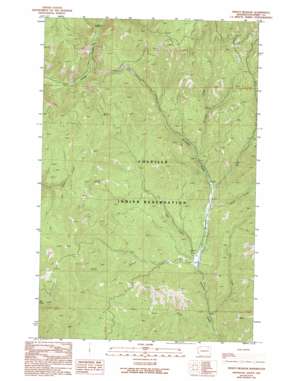
Frosty Meadows Topo Map Washington
To zoom in, hover over the map of Frosty Meadows
USGS Topo Quad 48118b5 - 1:24,000 scale
| Topo Map Name: | Frosty Meadows |
| USGS Topo Quad ID: | 48118b5 |
| Print Size: | ca. 21 1/4" wide x 27" high |
| Southeast Coordinates: | 48.125° N latitude / 118.5° W longitude |
| Map Center Coordinates: | 48.1875° N latitude / 118.5625° W longitude |
| U.S. State: | WA |
| Filename: | o48118b5.jpg |
| Download Map JPG Image: | Frosty Meadows topo map 1:24,000 scale |
| Map Type: | Topographic |
| Topo Series: | 7.5´ |
| Map Scale: | 1:24,000 |
| Source of Map Images: | United States Geological Survey (USGS) |
| Alternate Map Versions: |
Frosty Meadow WA 1989, updated 1989 Download PDF Buy paper map Frosty Meadow WA 1989, updated 1994 Download PDF Buy paper map Frosty Meadow WA 2011 Download PDF Buy paper map Frosty Meadow WA 2014 Download PDF Buy paper map |
1:24,000 Topo Quads surrounding Frosty Meadows
> Back to 48118a1 at 1:100,000 scale
> Back to 48118a1 at 1:250,000 scale
> Back to U.S. Topo Maps home
Frosty Meadows topo map: Gazetteer
Frosty Meadows: Flats
Frosty Meadow elevation 695m 2280′Frosty Meadows: Streams
Cook Creek elevation 656m 2152′Fay Creek elevation 658m 2158′
Gibson Creek elevation 713m 2339′
Jones Creek elevation 675m 2214′
Klondyke Creek elevation 732m 2401′
Pollock Creek elevation 676m 2217′
Wells Creek elevation 711m 2332′
Frosty Meadows digital topo map on disk
Buy this Frosty Meadows topo map showing relief, roads, GPS coordinates and other geographical features, as a high-resolution digital map file on DVD:


