La Fleur Lake Topo Map Washington
To zoom in, hover over the map of La Fleur Lake
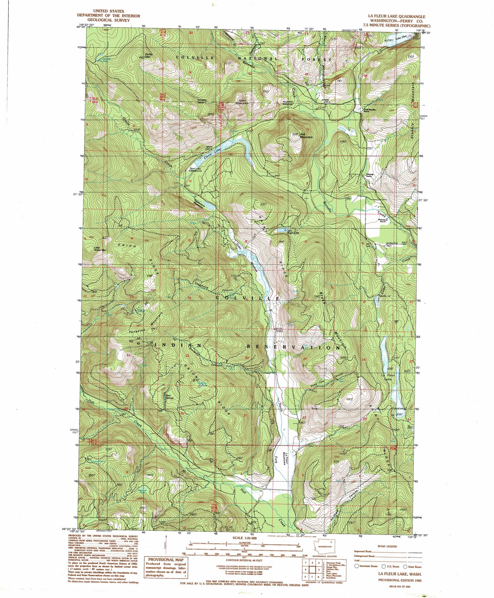
USGS Topo Quad 48118d3 - 1:24,000 scale
| Topo Map Name: | La Fleur Lake |
| USGS Topo Quad ID: | 48118d3 |
| Print Size: | ca. 21 1/4" wide x 27" high |
| Southeast Coordinates: | 48.375° N latitude / 118.25° W longitude |
| Map Center Coordinates: | 48.4375° N latitude / 118.3125° W longitude |
| U.S. State: | WA |
| Filename: | o48118d3.jpg |
| Download Map JPG Image: | La Fleur Lake topo map 1:24,000 scale |
| Map Type: | Topographic |
| Topo Series: | 7.5´ |
| Map Scale: | 1:24,000 |
| Source of Map Images: | United States Geological Survey (USGS) |
| Alternate Map Versions: |
La Fleur Lake WA 1985, updated 1985 Download PDF Buy paper map La Fleur Lake WA 1992, updated 1996 Download PDF Buy paper map La Fleur Lake WA 2011 Download PDF Buy paper map La Fleur Lake WA 2014 Download PDF Buy paper map |
| FStopo: | US Forest Service topo La Fleur Lake is available: Download FStopo PDF Download FStopo TIF |
1:24,000 Topo Quads surrounding La Fleur Lake
Cooke Mountain |
Copper Butte |
Jackknife Mountain |
Boyds |
Marcus |
Edds Mountain |
Sherman Peak |
South Huckleberry Mountain |
Bangs Mountain |
Kettle Falls |
Seventeenmile Mountain |
Sitdown Mountain |
La Fleur Lake |
Rice |
Kentry Ridge |
Cody Lake |
Twin Lakes |
Moon Mountain |
Inchelium |
Wellington Peak |
Frosty Meadows |
Gold Mountain |
Kewa |
Cedonia |
Blackhorse Canyon |
> Back to 48118a1 at 1:100,000 scale
> Back to 48118a1 at 1:250,000 scale
> Back to U.S. Topo Maps home
La Fleur Lake topo map: Gazetteer
La Fleur Lake: Flats
LaFleur Meadows elevation 610m 2001′Peppermint Meadows elevation 645m 2116′
La Fleur Lake: Lakes
Elbow Lake elevation 657m 2155′La Fleur Lake elevation 690m 2263′
Sugar Lake elevation 763m 2503′
La Fleur Lake: Ridges
Onion Ridge elevation 1269m 4163′Rainy Ridge elevation 1052m 3451′
La Fleur Lake: Springs
Bear Springs elevation 934m 3064′La Fleur Lake: Streams
Cedar Creek elevation 651m 2135′Cottonwood Creek elevation 796m 2611′
Doukhobor Creek elevation 775m 2542′
Ledgerwood Creek elevation 641m 2103′
Onion Creek elevation 657m 2155′
La Fleur Lake: Summits
Ant Mountain elevation 1005m 3297′Brush Mountain elevation 1064m 3490′
Dollar Mountain elevation 1431m 4694′
Tungsten Mountain elevation 1296m 4251′
La Fleur Lake: Swamps
Finley Meadows elevation 629m 2063′La Fleur Lake: Valleys
Butterfly Canyon elevation 615m 2017′Chipmunk Canyon elevation 633m 2076′
La Fleur Lake digital topo map on disk
Buy this La Fleur Lake topo map showing relief, roads, GPS coordinates and other geographical features, as a high-resolution digital map file on DVD: