Kettle Falls Topo Map Washington
To zoom in, hover over the map of Kettle Falls
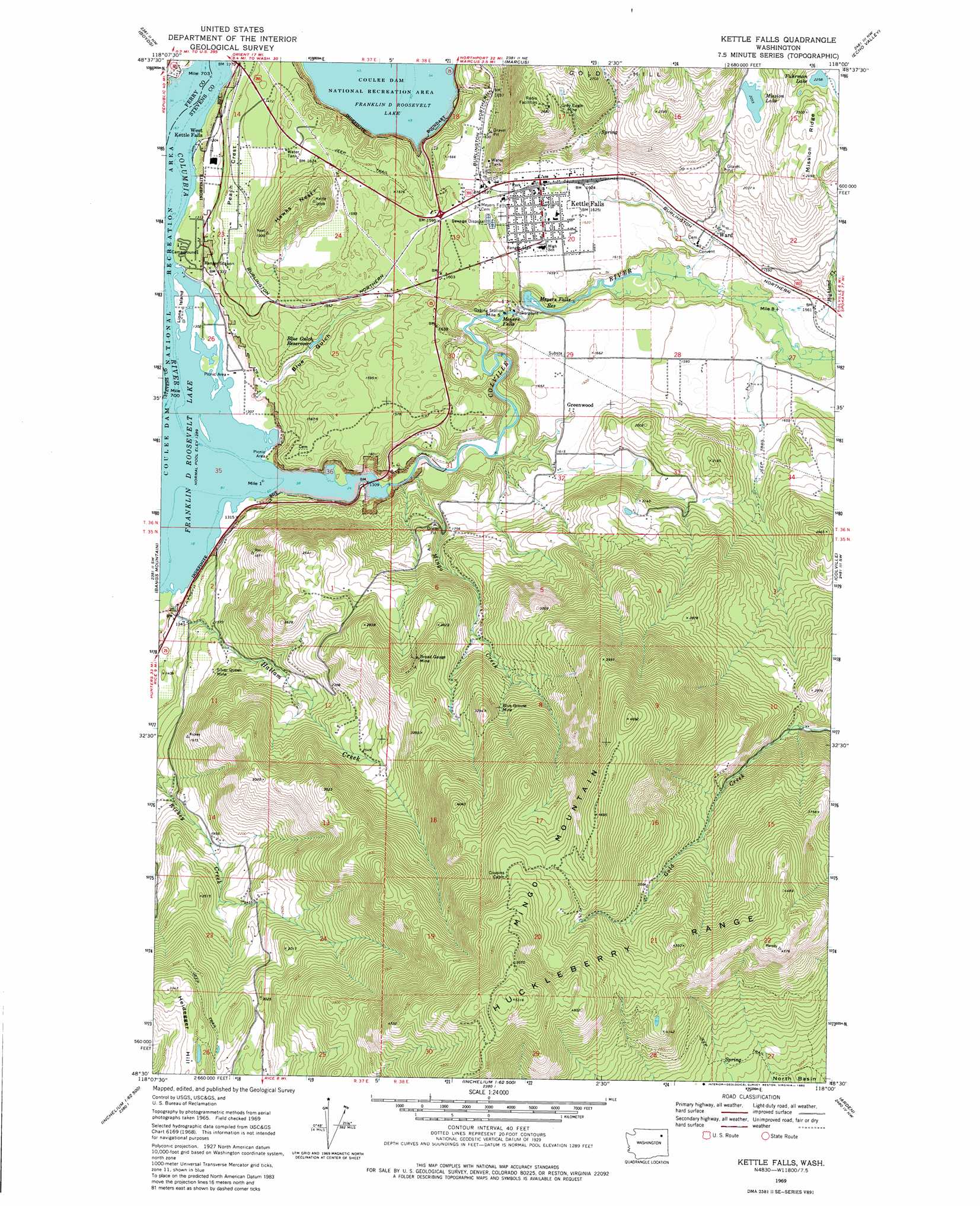
USGS Topo Quad 48118e1 - 1:24,000 scale
| Topo Map Name: | Kettle Falls |
| USGS Topo Quad ID: | 48118e1 |
| Print Size: | ca. 21 1/4" wide x 27" high |
| Southeast Coordinates: | 48.5° N latitude / 118° W longitude |
| Map Center Coordinates: | 48.5625° N latitude / 118.0625° W longitude |
| U.S. State: | WA |
| Filename: | o48118e1.jpg |
| Download Map JPG Image: | Kettle Falls topo map 1:24,000 scale |
| Map Type: | Topographic |
| Topo Series: | 7.5´ |
| Map Scale: | 1:24,000 |
| Source of Map Images: | United States Geological Survey (USGS) |
| Alternate Map Versions: |
Kettle Falls WA 1969, updated 1972 Download PDF Buy paper map Kettle Falls WA 1969, updated 1980 Download PDF Buy paper map Kettle Falls WA 2011 Download PDF Buy paper map Kettle Falls WA 2014 Download PDF Buy paper map |
1:24,000 Topo Quads surrounding Kettle Falls
Bulldog Mountain |
Orient |
Bossburg |
China Bend |
Onion Creek |
Jackknife Mountain |
Boyds |
Marcus |
Echo Valley |
Gillette Mountain |
South Huckleberry Mountain |
Bangs Mountain |
Kettle Falls |
Colville |
White Mud Lake |
La Fleur Lake |
Rice |
Kentry Ridge |
Arden |
Addy Mountain |
Moon Mountain |
Inchelium |
Wellington Peak |
Dunn Mountain |
Addy |
> Back to 48118e1 at 1:100,000 scale
> Back to 48118a1 at 1:250,000 scale
> Back to U.S. Topo Maps home
Kettle Falls topo map: Gazetteer
Kettle Falls: Dams
Blue Gulch Reservoir Dam elevation 429m 1407′Boise Cascade Mill Waste Pond Dam elevation 399m 1309′
Meyers Falls Dam elevation 466m 1528′
Kettle Falls: Falls
Meyers Falls elevation 447m 1466′Kettle Falls: Islands
Lions Island elevation 397m 1302′Kettle Falls: Lakes
Fuhrman Lake elevation 694m 2276′Mission Lake elevation 628m 2060′
Kettle Falls: Mines
Ark Mine elevation 541m 1774′Blue Grouse Mine elevation 877m 2877′
Broad Gauge Mine elevation 899m 2949′
Grey Eagle Mine elevation 714m 2342′
Silver Queen Mine elevation 528m 1732′
Kettle Falls: Parks
Old Kettle Falls Recreation Site elevation 395m 1295′Kettle Falls: Populated Places
Greenwood elevation 490m 1607′Kettle Falls elevation 497m 1630′
Ward elevation 494m 1620′
Kettle Falls: Reservoirs
Blue Gulch Reservoir elevation 429m 1407′Boise Cascade Mill Waste Pond elevation 399m 1309′
Meyers Falls Reservoir elevation 465m 1525′
Kettle Falls: Ridges
Mission Ridge elevation 741m 2431′Peach Crest elevation 433m 1420′
Kettle Falls: Streams
Colville River elevation 394m 1292′Hallam Creek elevation 395m 1295′
Highland Creek elevation 475m 1558′
Mingo Creek elevation 402m 1318′
Kettle Falls: Summits
Hawks Nest elevation 620m 2034′Mingo Mountain elevation 1428m 4685′
Kettle Falls: Valleys
Blue Gulch elevation 416m 1364′Kettle Falls digital topo map on disk
Buy this Kettle Falls topo map showing relief, roads, GPS coordinates and other geographical features, as a high-resolution digital map file on DVD: