Churchill Mountain Topo Map Washington
To zoom in, hover over the map of Churchill Mountain
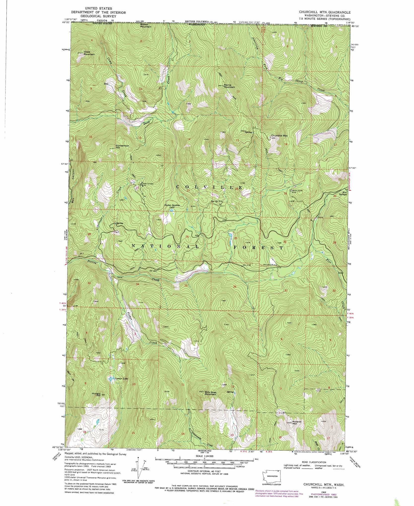
USGS Topo Quad 48118h1 - 1:24,000 scale
| Topo Map Name: | Churchill Mountain |
| USGS Topo Quad ID: | 48118h1 |
| Print Size: | ca. 21 1/4" wide x 27" high |
| Southeast Coordinates: | 48.875° N latitude / 118° W longitude |
| Map Center Coordinates: | 48.9375° N latitude / 118.0625° W longitude |
| U.S. State: | WA |
| Filename: | o48118h1.jpg |
| Download Map JPG Image: | Churchill Mountain topo map 1:24,000 scale |
| Map Type: | Topographic |
| Topo Series: | 7.5´ |
| Map Scale: | 1:24,000 |
| Source of Map Images: | United States Geological Survey (USGS) |
| Alternate Map Versions: |
Churchill Mtn WA 1969, updated 1971 Download PDF Buy paper map Churchill Mtn WA 1969, updated 1978 Download PDF Buy paper map Churchill Mtn WA 1969, updated 1982 Download PDF Buy paper map Churchill Mtn WA 1992, updated 1996 Download PDF Buy paper map Churchill Mountain WA 2011 Download PDF Buy paper map Churchill Mountain WA 2014 Download PDF Buy paper map |
| FStopo: | US Forest Service topo Churchill Mountain is available: Download FStopo PDF Download FStopo TIF |
1:24,000 Topo Quads surrounding Churchill Mountain
Independent Mountain |
Laurier |
Churchill Mountain |
Belshazzar Mountain |
Northport |
Bulldog Mountain |
Orient |
Bossburg |
China Bend |
Onion Creek |
Jackknife Mountain |
Boyds |
Marcus |
Echo Valley |
Gillette Mountain |
> Back to 48118e1 at 1:100,000 scale
> Back to 48118a1 at 1:250,000 scale
> Back to U.S. Topo Maps home
Churchill Mountain topo map: Gazetteer
Churchill Mountain: Lakes
Easter Sunday Lake elevation 1011m 3316′Lamar Lake elevation 951m 3120′
Churchill Mountain: Mines
Big Iron Mine elevation 1049m 3441′Churchill Mine elevation 960m 3149′
Easter Sunday Mine elevation 1080m 3543′
White Horse Mine elevation 1113m 3651′
Churchill Mountain: Springs
Kiel Springs elevation 996m 3267′Churchill Mountain: Streams
Camp Creek elevation 911m 2988′Fisher Creek elevation 728m 2388′
Limestone Creek elevation 709m 2326′
Churchill Mountain: Summits
Billy Goat Mountain elevation 1281m 4202′Bowen Mountain elevation 1577m 5173′
Churchill Mountain elevation 1465m 4806′
Contention Hill elevation 1251m 4104′
Hope Mountain elevation 1427m 4681′
Horns Mountain elevation 1528m 5013′
Hungry Hill elevation 1115m 3658′
Mineral Mountain elevation 1373m 4504′
Churchill Mountain digital topo map on disk
Buy this Churchill Mountain topo map showing relief, roads, GPS coordinates and other geographical features, as a high-resolution digital map file on DVD: