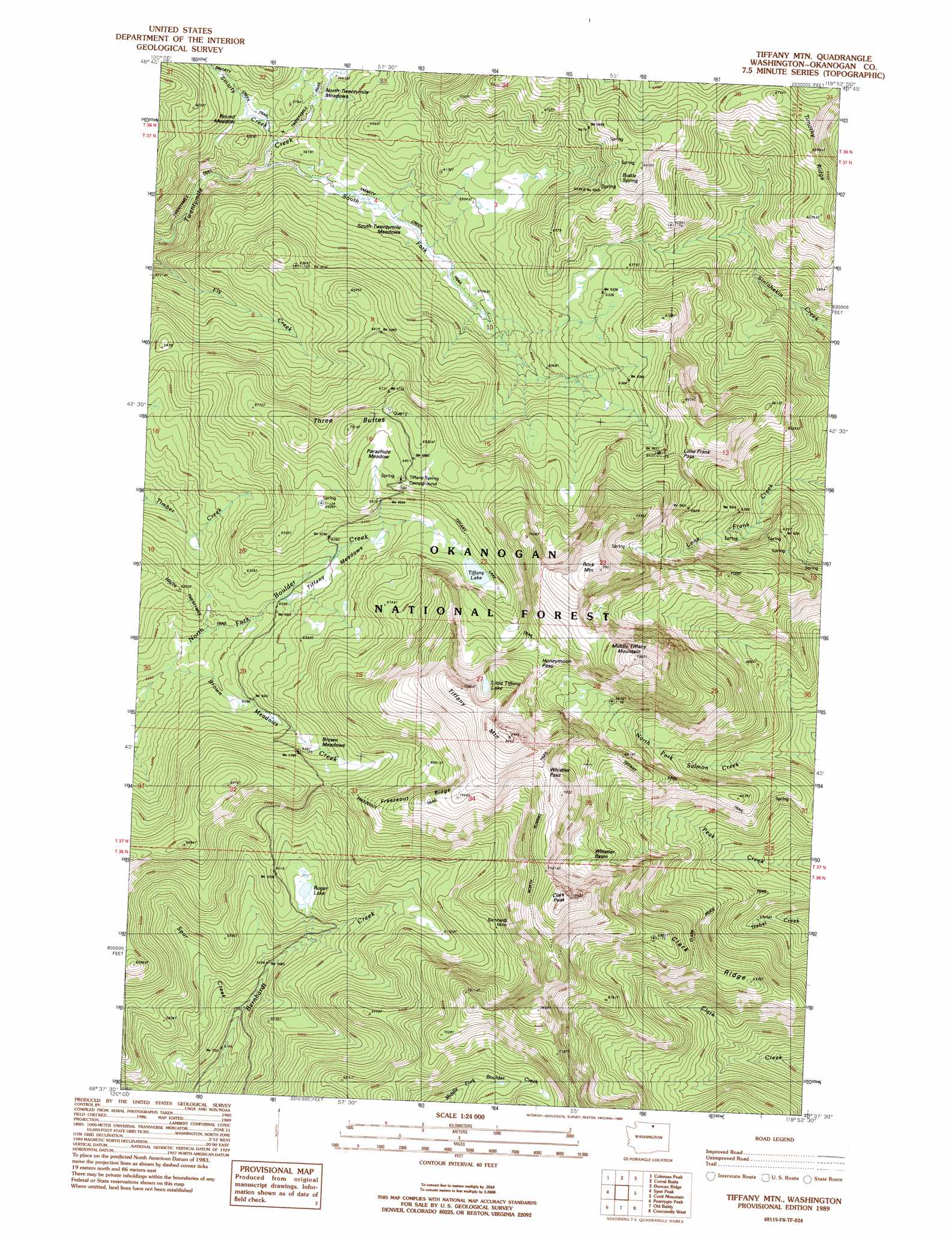
Tiffany Mountain Topo Map Washington
To zoom in, hover over the map of Tiffany Mountain
USGS Topo Quad 48119f8 - 1:24,000 scale
| Topo Map Name: | Tiffany Mountain |
| USGS Topo Quad ID: | 48119f8 |
| Print Size: | ca. 21 1/4" wide x 27" high |
| Southeast Coordinates: | 48.625° N latitude / 119.875° W longitude |
| Map Center Coordinates: | 48.6875° N latitude / 119.9375° W longitude |
| U.S. State: | WA |
| Filename: | o48119f8.jpg |
| Download Map JPG Image: | Tiffany Mountain topo map 1:24,000 scale |
| Map Type: | Topographic |
| Topo Series: | 7.5´ |
| Map Scale: | 1:24,000 |
| Source of Map Images: | United States Geological Survey (USGS) |
| Alternate Map Versions: |
Tiffany Mtn. WA 1989, updated 1989 Download PDF Buy paper map Tiffany Mountain WA 2001, updated 2004 Download PDF Buy paper map Tiffany Mountain WA 2011 Download PDF Buy paper map Tiffany Mountain WA 2014 Download PDF Buy paper map |
| FStopo: | US Forest Service topo Tiffany Mountain is available: Download FStopo PDF Download FStopo TIF |
1:24,000 Topo Quads surrounding Tiffany Mountain
Remmel Mountain |
Bauerman Ridge |
Horseshoe Basin |
Hurley Peak |
Nighthawk |
Mount Barney |
Coleman Peak |
Corral Butte |
Duncan Ridge |
Loomis |
Doe Mountain |
Spur Peak |
Tiffany Mountain |
Coxit Mountain |
Blue Goat Mountain |
Lewis Butte |
Pearrygin Peak |
Old Baldy |
Conconully West |
Conconully East |
Winthrop |
Blue Buck Mountain |
Loup Loup Summit |
Buck Mountain |
Ruby Hill |
> Back to 48119e1 at 1:100,000 scale
> Back to 48118a1 at 1:250,000 scale
> Back to U.S. Topo Maps home
Tiffany Mountain topo map: Gazetteer
Tiffany Mountain: Basins
Whistler Basin elevation 2080m 6824′Tiffany Mountain: Flats
Brown Meadows elevation 1920m 6299′Brown Meadows elevation 1911m 6269′
Parachute Meadow elevation 2057m 6748′
Round Meadow elevation 1716m 5629′
Tiffany Mountain: Gaps
Honeymoon Pass elevation 2167m 7109′Lone Frank Pass elevation 2032m 6666′
Whistler Pass elevation 2305m 7562′
Tiffany Mountain: Lakes
Little Tiffany Lake elevation 2265m 7431′Roger Lake elevation 1788m 5866′
Tiffany Lake elevation 1994m 6541′
Tiffany Mountain: Mines
Bernhardt Mine elevation 2168m 7112′Tiffany Mountain: Ranges
South Twentymile Meadows elevation 1737m 5698′Tiffany Meadows elevation 1885m 6184′
Tiffany Mountain: Ridges
Clark Ridge elevation 1923m 6309′Freezeout Ridge elevation 2275m 7463′
Timothy Ridge elevation 1980m 6496′
Tiffany Mountain: Springs
Bottle Spring elevation 2098m 6883′Tiffany Mountain: Streams
Brown Meadows Creek elevation 1778m 5833′Smarty Creek elevation 1683m 5521′
South Fork Twentymile Creek elevation 1664m 5459′
Spur Creek elevation 1584m 5196′
Tiffany Mountain: Summits
Clark Peak elevation 2359m 7739′Middle Tiffany Mountain elevation 2384m 7821′
Rock Mountain elevation 2427m 7962′
Three Buttes elevation 2101m 6893′
Tiffany Mountain elevation 2504m 8215′
Tiffany Mountain: Trails
Bernhardt Trail elevation 1875m 6151′Clark Ridge Trail elevation 1982m 6502′
Freezeout Trail elevation 1968m 6456′
North Summit Trail elevation 2255m 7398′
North Twentymile Trail elevation 1708m 5603′
Smarty Creek Trail elevation 1686m 5531′
Tiffany Lake Trail elevation 1939m 6361′
Tiffany Mountain digital topo map on disk
Buy this Tiffany Mountain topo map showing relief, roads, GPS coordinates and other geographical features, as a high-resolution digital map file on DVD: