Cooper Mountain Topo Map Washington
To zoom in, hover over the map of Cooper Mountain
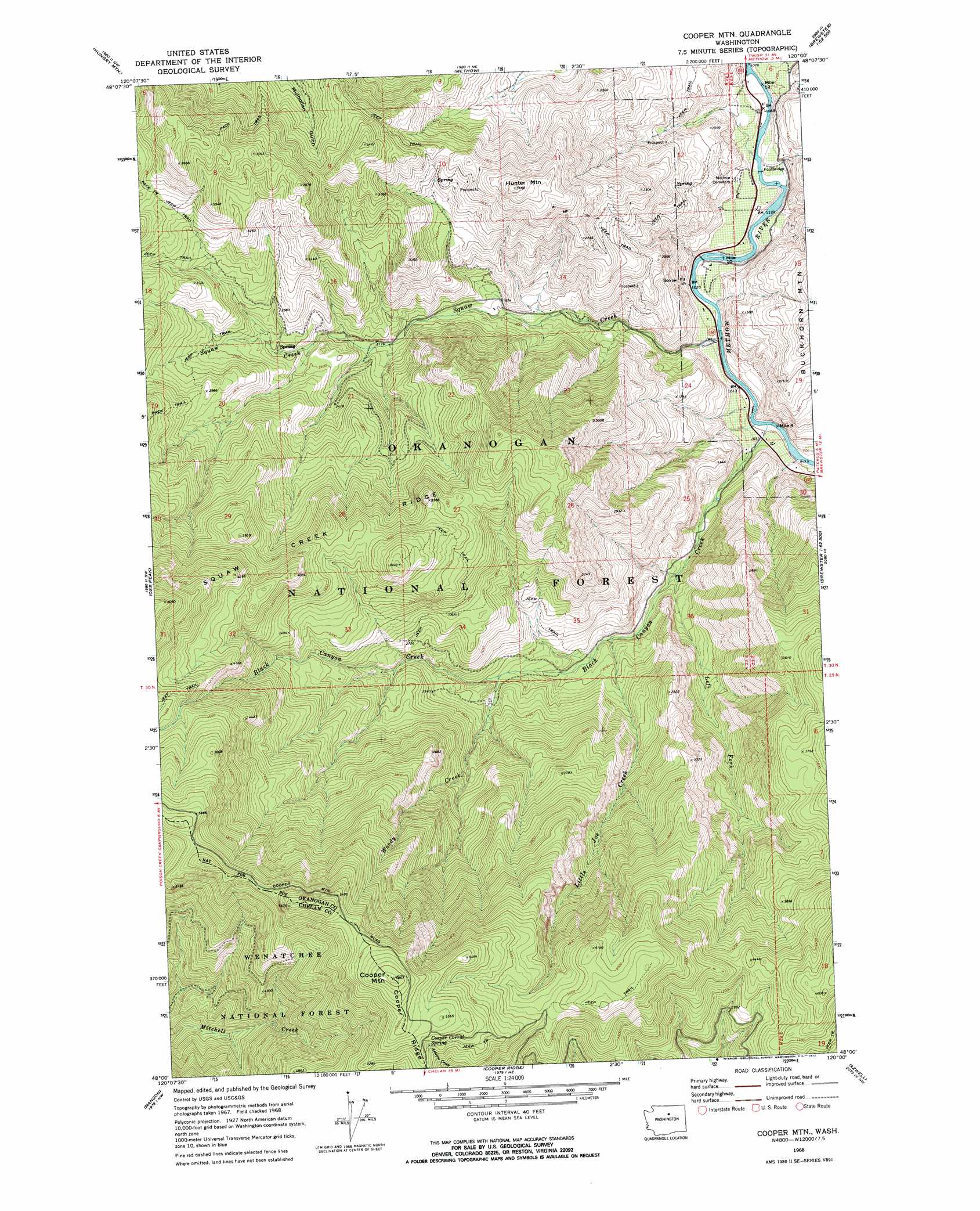
USGS Topo Quad 48120a1 - 1:24,000 scale
| Topo Map Name: | Cooper Mountain |
| USGS Topo Quad ID: | 48120a1 |
| Print Size: | ca. 21 1/4" wide x 27" high |
| Southeast Coordinates: | 48° N latitude / 120° W longitude |
| Map Center Coordinates: | 48.0625° N latitude / 120.0625° W longitude |
| U.S. State: | WA |
| Filename: | o48120a1.jpg |
| Download Map JPG Image: | Cooper Mountain topo map 1:24,000 scale |
| Map Type: | Topographic |
| Topo Series: | 7.5´ |
| Map Scale: | 1:24,000 |
| Source of Map Images: | United States Geological Survey (USGS) |
| Alternate Map Versions: |
Cooper Mtn WA 1968, updated 1972 Download PDF Buy paper map Cooper Mtn WA 1968, updated 1972 Download PDF Buy paper map Cooper Mountain WA 2001, updated 2004 Download PDF Buy paper map Cooper Mountain WA 2011 Download PDF Buy paper map Cooper Mountain WA 2014 Download PDF Buy paper map |
| FStopo: | US Forest Service topo Cooper Mountain is available: Download FStopo PDF Download FStopo TIF |
1:24,000 Topo Quads surrounding Cooper Mountain
Hoodoo Peak |
Twisp West |
Twisp East |
Thrapp Mountain |
Chiliwist Valley |
Martin Peak |
Hungry Mountain |
Methow |
Knowton Knob |
Rat Lake |
South Navarre Peak |
Oss Peak |
Cooper Mountain |
Pateros |
Brewster |
Stormy Mountain |
Manson |
Cooper Ridge |
Azwell |
Wells Dam |
Baldy Mountain |
Winesap |
Chelan |
Chelan Falls |
Mud Spring |
> Back to 48120a1 at 1:100,000 scale
> Back to 48120a1 at 1:250,000 scale
> Back to U.S. Topo Maps home
Cooper Mountain topo map: Gazetteer
Cooper Mountain: Ridges
Cooper Ridge elevation 1722m 5649′Squaw Creek Ridge elevation 1307m 4288′
Cooper Mountain: Springs
Cooper Corral Spring elevation 1620m 5314′Gold Spring elevation 1363m 4471′
Cooper Mountain: Streams
Black Canyon Creek elevation 296m 971′Left Fork elevation 461m 1512′
Left Fork Black Canyon Creek elevation 461m 1512′
Little Joe Creek elevation 549m 1801′
Squaw Creek elevation 305m 1000′
Woody Creek elevation 658m 2158′
Cooper Mountain: Summits
Cooper Mountain elevation 1785m 5856′Hunter Mountain elevation 1041m 3415′
Cooper Mountain: Valleys
Black Canyon elevation 318m 1043′Cooper Mountain digital topo map on disk
Buy this Cooper Mountain topo map showing relief, roads, GPS coordinates and other geographical features, as a high-resolution digital map file on DVD: