Lucerne Topo Map Washington
To zoom in, hover over the map of Lucerne
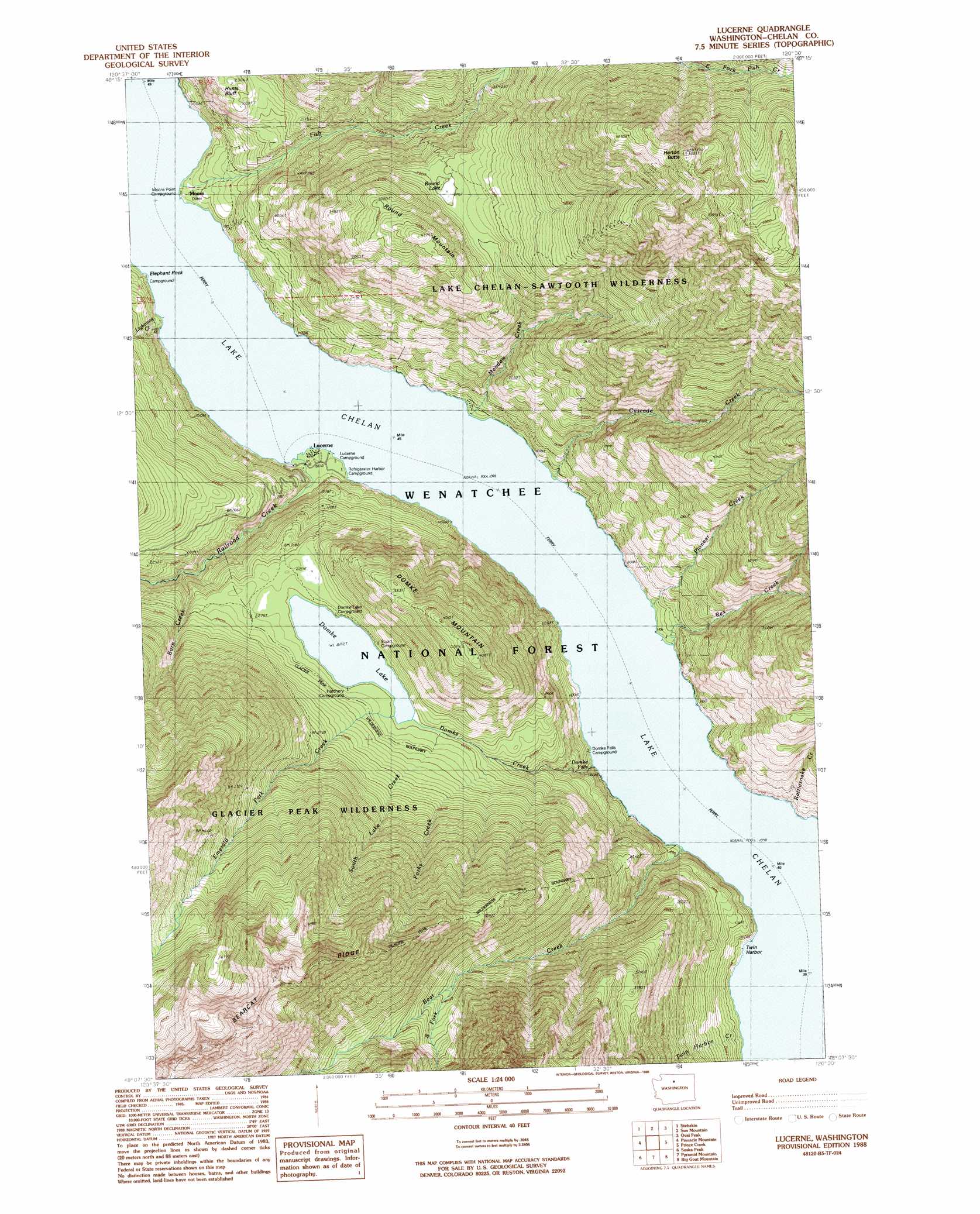
USGS Topo Quad 48120b5 - 1:24,000 scale
| Topo Map Name: | Lucerne |
| USGS Topo Quad ID: | 48120b5 |
| Print Size: | ca. 21 1/4" wide x 27" high |
| Southeast Coordinates: | 48.125° N latitude / 120.5° W longitude |
| Map Center Coordinates: | 48.1875° N latitude / 120.5625° W longitude |
| U.S. State: | WA |
| Filename: | o48120b5.jpg |
| Download Map JPG Image: | Lucerne topo map 1:24,000 scale |
| Map Type: | Topographic |
| Topo Series: | 7.5´ |
| Map Scale: | 1:24,000 |
| Source of Map Images: | United States Geological Survey (USGS) |
| Alternate Map Versions: |
Lucerne WA 1988, updated 1988 Download PDF Buy paper map Lucerne WA 2004, updated 2008 Download PDF Buy paper map Lucerne WA 2011 Download PDF Buy paper map Lucerne WA 2014 Download PDF Buy paper map |
| FStopo: | US Forest Service topo Lucerne is available: Download FStopo PDF Download FStopo TIF |
1:24,000 Topo Quads surrounding Lucerne
Mcgregor Mountain |
Mcalester Mountain |
Gilbert |
Midnight Mountain |
Thompson Ridge |
Mount Lyall |
Stehekin |
Sun Mountain |
Oval Peak |
Hoodoo Peak |
Holden |
Pinnacle Mountain |
Lucerne |
Prince Creek |
Martin Peak |
Trinity |
Saska Peak |
Pyramid Mountain |
Big Goat Mountain |
South Navarre Peak |
Schaefer Lake |
Chikamin Creek |
Silver Falls |
Brief |
Stormy Mountain |
> Back to 48120a1 at 1:100,000 scale
> Back to 48120a1 at 1:250,000 scale
> Back to U.S. Topo Maps home
Lucerne topo map: Gazetteer
Lucerne: Bays
Twin Harbor elevation 336m 1102′Lucerne: Cliffs
Hunts Bluff elevation 697m 2286′Moore Point elevation 358m 1174′
Lucerne: Falls
Domke Falls elevation 363m 1190′Lucerne: Lakes
Domke Lake elevation 669m 2194′Round Lake elevation 974m 3195′
Lucerne: Mines
Prospect Mine elevation 1320m 4330′Lucerne: Populated Places
Domke Lake Resort elevation 672m 2204′Lucerne elevation 338m 1108′
Moore elevation 343m 1125′
Lucerne: Post Offices
Lucerne Post Office (historical) elevation 338m 1108′Lucerne: Ridges
Bearcat Ridge elevation 2248m 7375′Lucerne: Streams
Bear Creek elevation 336m 1102′Burn Creek elevation 536m 1758′
Cascade Creek elevation 344m 1128′
Domke Creek elevation 337m 1105′
Emerald Park Creek elevation 669m 2194′
Fish Creek elevation 336m 1102′
Forks Creek elevation 606m 1988′
Lighting Creek elevation 336m 1102′
Meadow Creek elevation 336m 1102′
Pioneer Creek elevation 344m 1128′
Railroad Creek elevation 336m 1102′
Rattlesnake Creek elevation 340m 1115′
Rex Creek elevation 351m 1151′
South Fork Bear Creek elevation 1194m 3917′
South Lake Creek elevation 663m 2175′
Twin Harbor Creek elevation 345m 1131′
Lucerne: Summits
Domke Mountain elevation 1190m 3904′Elephant Rock elevation 341m 1118′
Horton Butte elevation 2079m 6820′
Round Mountain elevation 1333m 4373′
Lucerne digital topo map on disk
Buy this Lucerne topo map showing relief, roads, GPS coordinates and other geographical features, as a high-resolution digital map file on DVD: