Billy Goat Mountain Topo Map Washington
To zoom in, hover over the map of Billy Goat Mountain
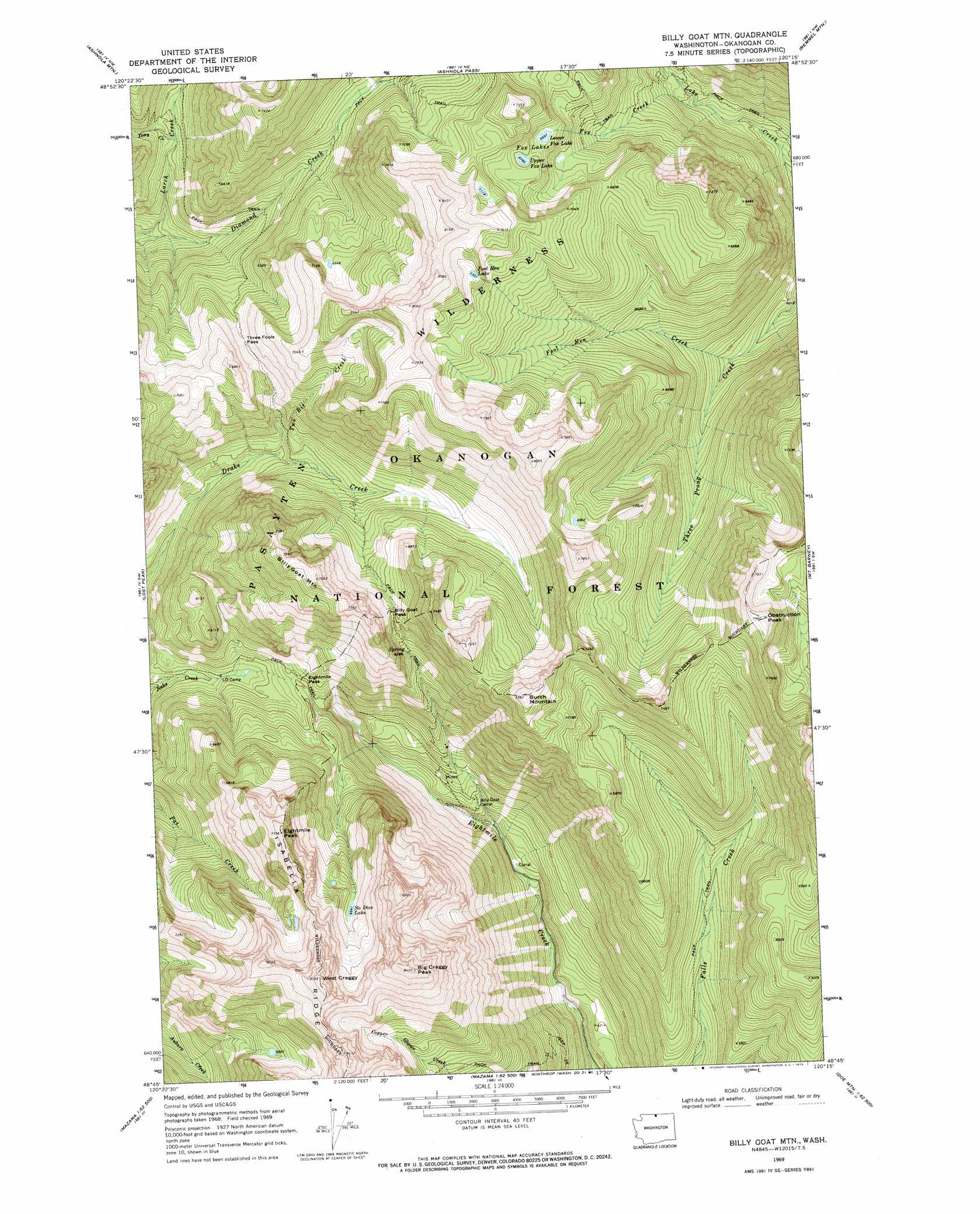
USGS Topo Quad 48120g3 - 1:24,000 scale
| Topo Map Name: | Billy Goat Mountain |
| USGS Topo Quad ID: | 48120g3 |
| Print Size: | ca. 21 1/4" wide x 27" high |
| Southeast Coordinates: | 48.75° N latitude / 120.25° W longitude |
| Map Center Coordinates: | 48.8125° N latitude / 120.3125° W longitude |
| U.S. State: | WA |
| Filename: | o48120g3.jpg |
| Download Map JPG Image: | Billy Goat Mountain topo map 1:24,000 scale |
| Map Type: | Topographic |
| Topo Series: | 7.5´ |
| Map Scale: | 1:24,000 |
| Source of Map Images: | United States Geological Survey (USGS) |
| Alternate Map Versions: |
Billy Goat Mtn WA 1969, updated 1973 Download PDF Buy paper map Billy Goat Mtn WA 1969, updated 1973 Download PDF Buy paper map Billy Goat Mountain WA 2002, updated 2006 Download PDF Buy paper map Billy Goat Mountain WA 2011 Download PDF Buy paper map Billy Goat Mountain WA 2014 Download PDF Buy paper map |
| FStopo: | US Forest Service topo Billy Goat Mountain is available: Download FStopo PDF Download FStopo TIF |
1:24,000 Topo Quads surrounding Billy Goat Mountain
Tatoosh Buttes |
Ashnola Mountain |
Ashnola Pass |
Remmel Mountain |
Bauerman Ridge |
Mount Lago |
Lost Peak |
Billy Goat Mountain |
Mount Barney |
Coleman Peak |
Robinson Mountain |
Mcleod Mountain |
Sweetgrass Butte |
Doe Mountain |
Spur Peak |
Silver Star Mountain |
Mazama |
Rendevous Mountain |
Lewis Butte |
Pearrygin Peak |
> Back to 48120e1 at 1:100,000 scale
> Back to 48120a1 at 1:250,000 scale
> Back to U.S. Topo Maps home
Billy Goat Mountain topo map: Gazetteer
Billy Goat Mountain: Cliffs
West Craggy elevation 2512m 8241′Billy Goat Mountain: Gaps
Billy Goat Pass elevation 1999m 6558′Eightmile Pass elevation 1666m 5465′
Three Fools Pass elevation 1840m 6036′
Billy Goat Mountain: Lakes
Fool Hen Lake elevation 2253m 7391′Fox Lakes elevation 2049m 6722′
Lower Fox Lake elevation 2043m 6702′
No Dice Lake elevation 1998m 6555′
Upper Fox Lake elevation 2071m 6794′
Billy Goat Mountain: Streams
Carol Creek elevation 1482m 4862′Fool Hen Creek elevation 1558m 5111′
Fox Creek elevation 1557m 5108′
Larch Creek elevation 1497m 4911′
Newland Creek elevation 1602m 5255′
Tony Creek elevation 1672m 5485′
Two Bit Creek elevation 1632m 5354′
Billy Goat Mountain: Summits
Big Craggy Peak elevation 2575m 8448′Billy Goat Mountain elevation 2292m 7519′
Burch Mountain elevation 2361m 7746′
Eightmile Peak elevation 2331m 7647′
Obstruction Peak elevation 2419m 7936′
Billy Goat Mountain digital topo map on disk
Buy this Billy Goat Mountain topo map showing relief, roads, GPS coordinates and other geographical features, as a high-resolution digital map file on DVD: