Pasayten Peak Topo Map Washington
To zoom in, hover over the map of Pasayten Peak
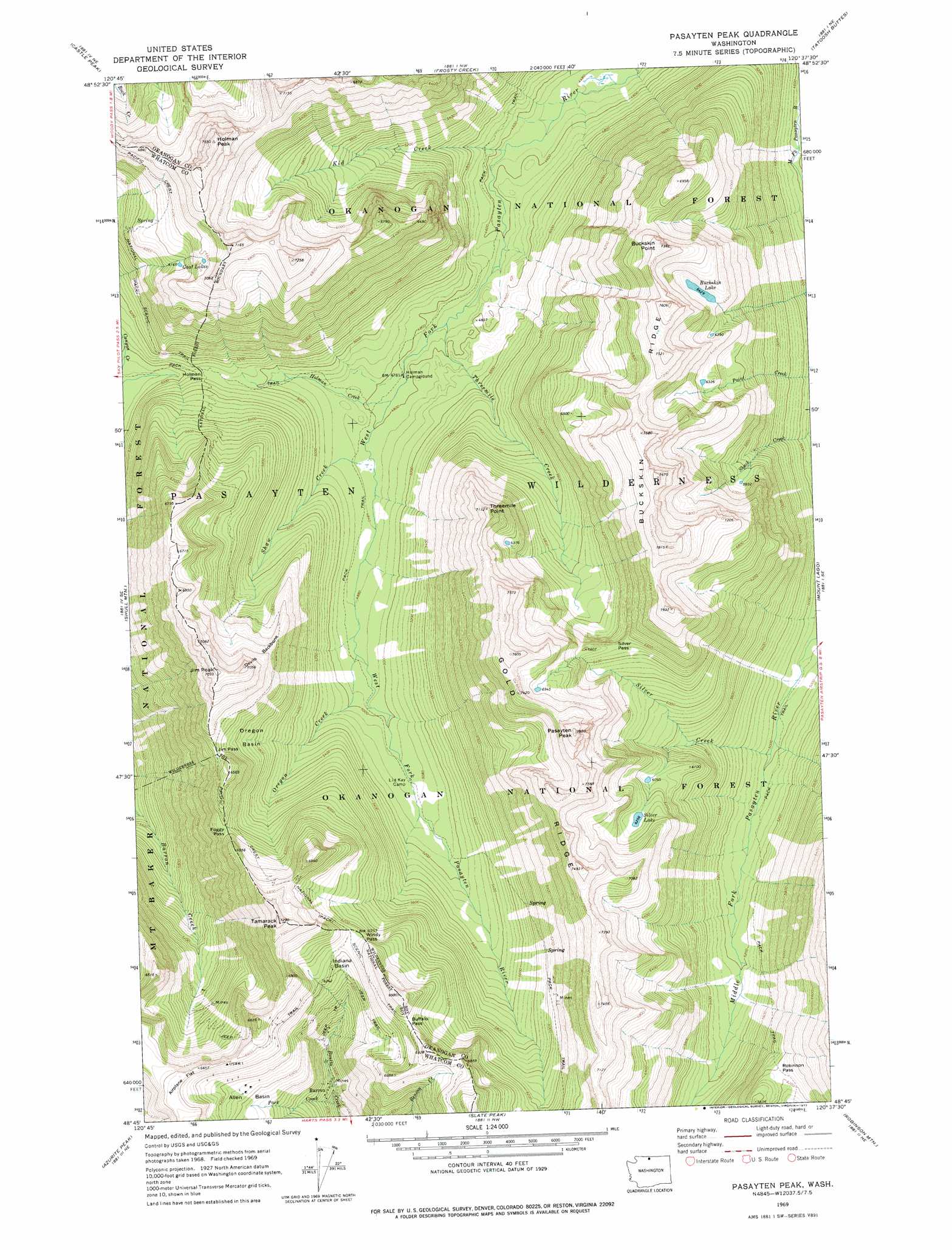
USGS Topo Quad 48120g6 - 1:24,000 scale
| Topo Map Name: | Pasayten Peak |
| USGS Topo Quad ID: | 48120g6 |
| Print Size: | ca. 21 1/4" wide x 27" high |
| Southeast Coordinates: | 48.75° N latitude / 120.625° W longitude |
| Map Center Coordinates: | 48.8125° N latitude / 120.6875° W longitude |
| U.S. State: | WA |
| Filename: | o48120g6.jpg |
| Download Map JPG Image: | Pasayten Peak topo map 1:24,000 scale |
| Map Type: | Topographic |
| Topo Series: | 7.5´ |
| Map Scale: | 1:24,000 |
| Source of Map Images: | United States Geological Survey (USGS) |
| Alternate Map Versions: |
Pasayten Peak WA 1969, updated 1973 Download PDF Buy paper map Pasayten Peak WA 1969, updated 1977 Download PDF Buy paper map Pasayten Peak WA 2002, updated 2006 Download PDF Buy paper map Pasayten Peak WA 2011 Download PDF Buy paper map Pasayten Peak WA 2014 Download PDF Buy paper map |
| FStopo: | US Forest Service topo Pasayten Peak is available: Download FStopo PDF Download FStopo TIF |
1:24,000 Topo Quads surrounding Pasayten Peak
Skagit Peak |
Castle Peak |
Frosty Creek |
Tatoosh Buttes |
Ashnola Mountain |
Jack Mountain |
Shull Mountain |
Pasayten Peak |
Mount Lago |
Lost Peak |
Crater Mountain |
Azurite Peak |
Slate Peak |
Robinson Mountain |
Mcleod Mountain |
Mount Logan |
Mount Arriva |
Washington Pass |
Silver Star Mountain |
Mazama |
> Back to 48120e1 at 1:100,000 scale
> Back to 48120a1 at 1:250,000 scale
> Back to U.S. Topo Maps home
Pasayten Peak topo map: Gazetteer
Pasayten Peak: Basins
Indiana Basin elevation 1882m 6174′Oregon Basin elevation 1782m 5846′
Pasayten Peak: Gaps
Buffalo Pass elevation 1995m 6545′Foggy Pass elevation 1872m 6141′
Holman Pass elevation 1544m 5065′
Jim Pass elevation 1914m 6279′
Robinson Pass elevation 1895m 6217′
Silver Pass elevation 1980m 6496′
Windy Pass elevation 1907m 6256′
Pasayten Peak: Lakes
Buckskin Lake elevation 1961m 6433′Goat Lakes elevation 1952m 6404′
Silver Lake elevation 1908m 6259′
Pasayten Peak: Populated Places
Barron elevation 1591m 5219′Pasayten Peak: Ridges
Buckskin Ridge elevation 2308m 7572′Devils Backbone elevation 2139m 7017′
Gold Ridge elevation 2230m 7316′
Pasayten Peak: Streams
Benson Creek elevation 2038m 6686′Bonita Creek elevation 2091m 6860′
Holman Creek elevation 1459m 4786′
Kid Creek elevation 1387m 4550′
Oregon Creek elevation 1499m 4917′
Park Creek elevation 1573m 5160′
Shaw Creek elevation 1469m 4819′
Silver Creek elevation 1524m 5000′
Threemile Creek elevation 1436m 4711′
Pasayten Peak: Summits
Buckskin Point elevation 2245m 7365′Holman Peak elevation 2286m 7500′
Jim Peak elevation 2134m 7001′
Pasayten Peak elevation 2354m 7723′
Tamarack Peak elevation 2204m 7230′
Threemile Point elevation 1625m 5331′
Pasayten Peak digital topo map on disk
Buy this Pasayten Peak topo map showing relief, roads, GPS coordinates and other geographical features, as a high-resolution digital map file on DVD: