Glacier Peak West Topo Map Washington
To zoom in, hover over the map of Glacier Peak West
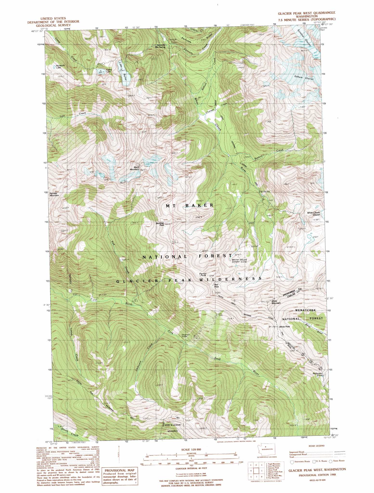
USGS Topo Quad 48121a2 - 1:24,000 scale
| Topo Map Name: | Glacier Peak West |
| USGS Topo Quad ID: | 48121a2 |
| Print Size: | ca. 21 1/4" wide x 27" high |
| Southeast Coordinates: | 48° N latitude / 121.125° W longitude |
| Map Center Coordinates: | 48.0625° N latitude / 121.1875° W longitude |
| U.S. State: | WA |
| Filename: | o48121a2.jpg |
| Download Map JPG Image: | Glacier Peak West topo map 1:24,000 scale |
| Map Type: | Topographic |
| Topo Series: | 7.5´ |
| Map Scale: | 1:24,000 |
| Source of Map Images: | United States Geological Survey (USGS) |
| Alternate Map Versions: |
Glacier Peak West WA 1988, updated 1988 Download PDF Buy paper map Glacier Peak West WA 1999, updated 2002 Download PDF Buy paper map Glacier Peak West WA 2011 Download PDF Buy paper map Glacier Peak West WA 2014 Download PDF Buy paper map |
| FStopo: | US Forest Service topo Glacier Peak West is available: Download FStopo PDF Download FStopo TIF |
1:24,000 Topo Quads surrounding Glacier Peak West
Prairie Mountain |
Huckleberry Mountain |
Downey Mountain |
Dome Peak |
Agnes Mountain |
White Chuck Mountain |
Pugh Mountain |
Lime Mountain |
Gamma Peak |
Suiattle Pass |
Bedal |
Sloan Peak |
Glacier Peak West |
Glacier Peak East |
Clark Mountain |
Monte Cristo |
Blanca Lake |
Benchmark Mountain |
Poe Mountain |
Mount David |
Baring |
Evergreen Mountain |
Captain Point |
Labyrinth Mountain |
Mount Howard |
> Back to 48121a1 at 1:100,000 scale
> Back to 48120a1 at 1:250,000 scale
> Back to U.S. Topo Maps home
Glacier Peak West topo map: Gazetteer
Glacier Peak West: Gaps
Red Pass elevation 1955m 6414′White Pass elevation 1790m 5872′
Glacier Peak West: Glaciers
Scimitar Glacier elevation 2498m 8195′Sitkum Glacier elevation 2521m 8270′
Glacier Peak West: Lakes
Camp Lake elevation 1740m 5708′Hardtack Lake elevation 1657m 5436′
Kid Pond elevation 1607m 5272′
Lake Byrne elevation 1691m 5547′
Reflection Pond elevation 1696m 5564′
Van Lake elevation 1749m 5738′
Glacier Peak West: Streams
Baekos Creek elevation 1161m 3809′Chetwot Creek elevation 1121m 3677′
Chikamin Creek elevation 876m 2874′
Kennedy Creek elevation 983m 3225′
Red Creek elevation 847m 2778′
Sitkum Creek elevation 1125m 3690′
Skalabats Creek elevation 796m 2611′
Tahlak Creek elevation 808m 2650′
Glacier Peak West: Summits
Black Mountain elevation 2130m 6988′Portal Peak elevation 2060m 6758′
Skullcap Peak elevation 1994m 6541′
White Chuck Cinder Cone elevation 1827m 5994′
White Mountain elevation 2141m 7024′
Glacier Peak West digital topo map on disk
Buy this Glacier Peak West topo map showing relief, roads, GPS coordinates and other geographical features, as a high-resolution digital map file on DVD: