Bedal Topo Map Washington
To zoom in, hover over the map of Bedal
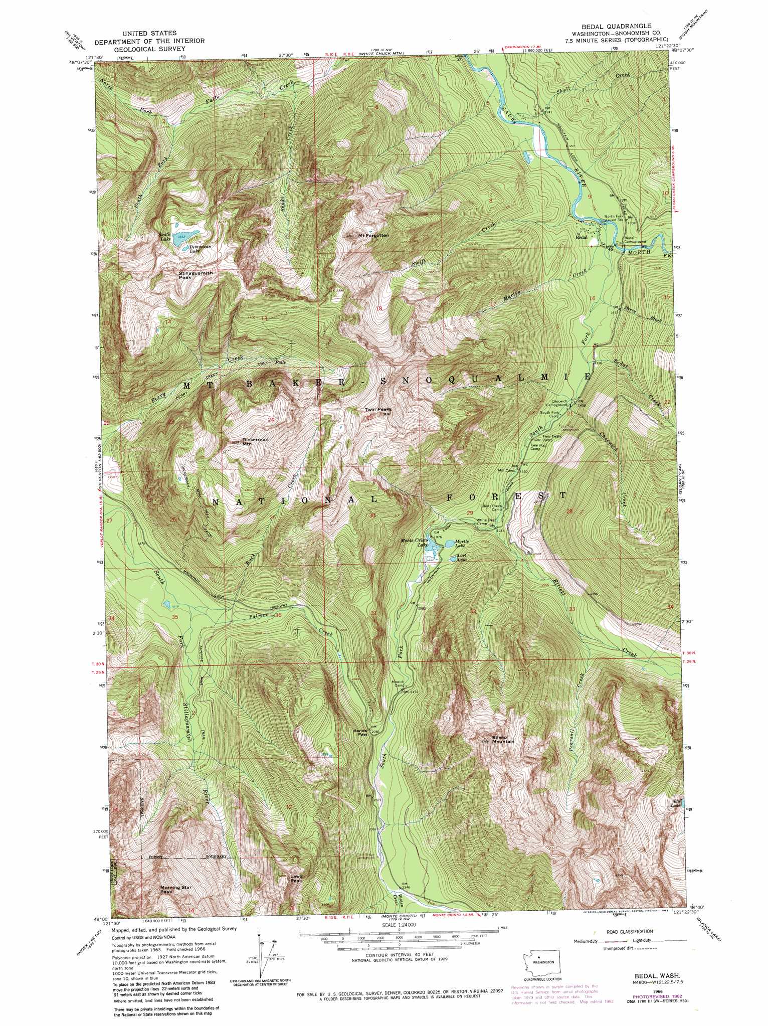
USGS Topo Quad 48121a4 - 1:24,000 scale
| Topo Map Name: | Bedal |
| USGS Topo Quad ID: | 48121a4 |
| Print Size: | ca. 21 1/4" wide x 27" high |
| Southeast Coordinates: | 48° N latitude / 121.375° W longitude |
| Map Center Coordinates: | 48.0625° N latitude / 121.4375° W longitude |
| U.S. State: | WA |
| Filename: | o48121a4.jpg |
| Download Map JPG Image: | Bedal topo map 1:24,000 scale |
| Map Type: | Topographic |
| Topo Series: | 7.5´ |
| Map Scale: | 1:24,000 |
| Source of Map Images: | United States Geological Survey (USGS) |
| Alternate Map Versions: |
Bedal WA 1966, updated 1968 Download PDF Buy paper map Bedal WA 1966, updated 1973 Download PDF Buy paper map Bedal WA 1966, updated 1983 Download PDF Buy paper map Bedal WA 1966, updated 1983 Download PDF Buy paper map Bedal WA 2011 Download PDF Buy paper map Bedal WA 2014 Download PDF Buy paper map |
| FStopo: | US Forest Service topo Bedal is available: Download FStopo PDF Download FStopo TIF |
1:24,000 Topo Quads surrounding Bedal
Fortson |
Darrington |
Prairie Mountain |
Huckleberry Mountain |
Downey Mountain |
Whitehorse Mountain |
Helena Ridge |
White Chuck Mountain |
Pugh Mountain |
Lime Mountain |
Mallardy Ridge |
Silverton |
Bedal |
Sloan Peak |
Glacier Peak West |
Wallace Lake |
Mount Stickney |
Monte Cristo |
Blanca Lake |
Benchmark Mountain |
Gold Bar |
Index |
Baring |
Evergreen Mountain |
Captain Point |
> Back to 48121a1 at 1:100,000 scale
> Back to 48120a1 at 1:250,000 scale
> Back to U.S. Topo Maps home
Bedal topo map: Gazetteer
Bedal: Gaps
Barlow Pass elevation 720m 2362′Headlee Pass elevation 1399m 4589′
Bedal: Lakes
Ida Lake elevation 1146m 3759′Lost Lake elevation 609m 1998′
Monte Cristo Lake elevation 593m 1945′
Myrtle Lake elevation 608m 1994′
Pemmican Lake elevation 1425m 4675′
South Lake elevation 1386m 4547′
Bedal: Populated Places
Bedal elevation 384m 1259′Bedal: Streams
Bedal Creek elevation 420m 1377′Buck Creek elevation 560m 1837′
Chocwich Creek elevation 427m 1400′
Elliott Creek elevation 508m 1666′
Martin Creek elevation 367m 1204′
Merry Brook elevation 389m 1276′
North Fork Falls Creek elevation 627m 2057′
North Fork Sauk River elevation 367m 1204′
Palmer Creek elevation 559m 1833′
Pearsall Creek elevation 698m 2290′
Shake Creek elevation 489m 1604′
Skull Creek elevation 348m 1141′
South Fork Falls Creek elevation 627m 2057′
South Fork Sauk River elevation 367m 1204′
Swift Creek elevation 363m 1190′
Weeden Creek elevation 713m 2339′
Bedal: Summits
Barlow Point elevation 979m 3211′Lewis Peak elevation 1713m 5620′
Morning Star Peak elevation 1834m 6017′
Mount Dickerman elevation 1746m 5728′
Mount Forgotten elevation 1793m 5882′
Sheep Mountain elevation 1858m 6095′
Stillaguamish Peak elevation 1659m 5442′
Twin Peaks elevation 1713m 5620′
Bedal digital topo map on disk
Buy this Bedal topo map showing relief, roads, GPS coordinates and other geographical features, as a high-resolution digital map file on DVD: