Dome Peak Topo Map Washington
To zoom in, hover over the map of Dome Peak
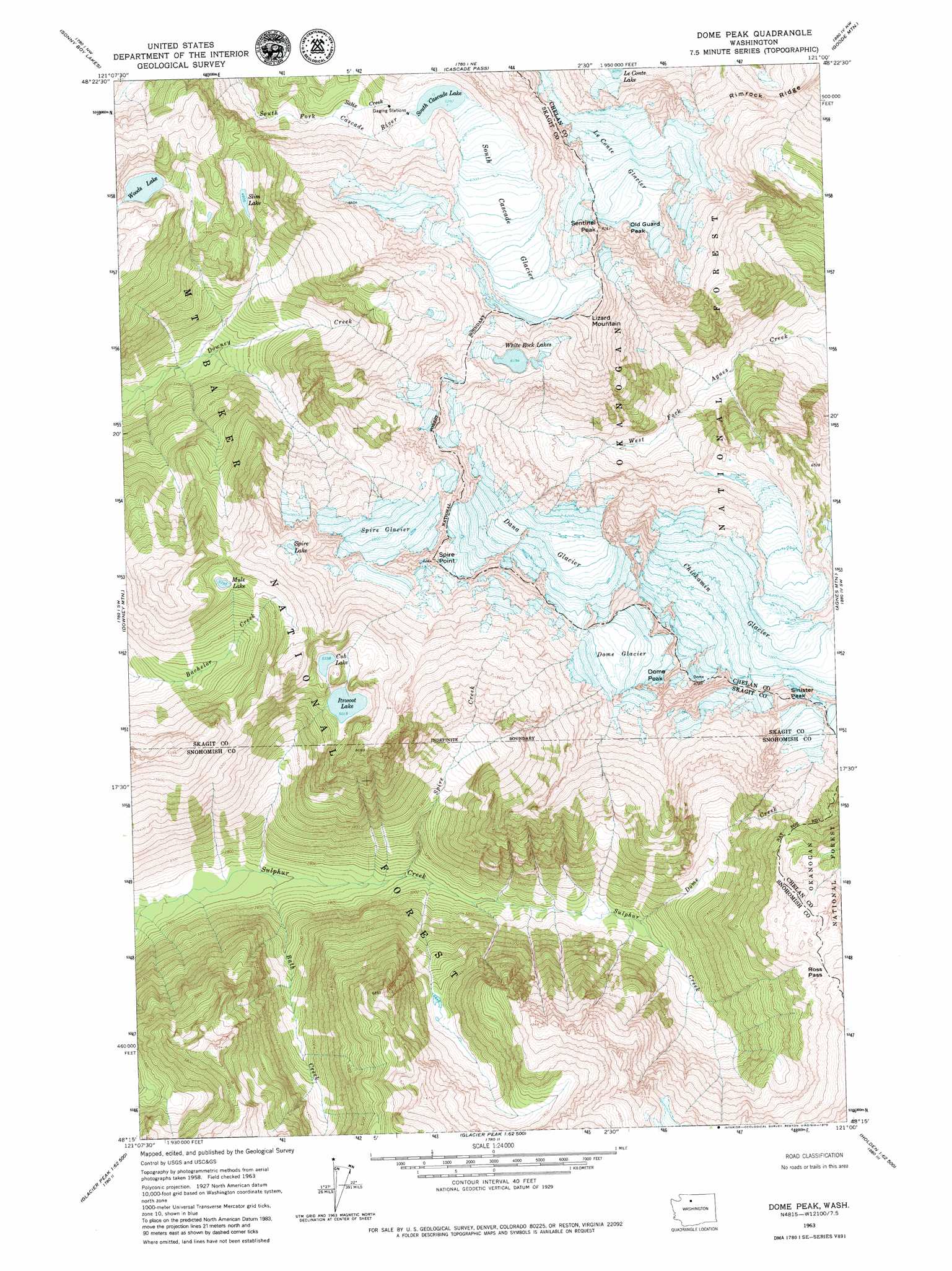
USGS Topo Quad 48121c1 - 1:24,000 scale
| Topo Map Name: | Dome Peak |
| USGS Topo Quad ID: | 48121c1 |
| Print Size: | ca. 21 1/4" wide x 27" high |
| Southeast Coordinates: | 48.25° N latitude / 121° W longitude |
| Map Center Coordinates: | 48.3125° N latitude / 121.0625° W longitude |
| U.S. State: | WA |
| Filename: | o48121c1.jpg |
| Download Map JPG Image: | Dome Peak topo map 1:24,000 scale |
| Map Type: | Topographic |
| Topo Series: | 7.5´ |
| Map Scale: | 1:24,000 |
| Source of Map Images: | United States Geological Survey (USGS) |
| Alternate Map Versions: |
Dome Peak WA 1963, updated 1965 Download PDF Buy paper map Dome Peak WA 1963, updated 1967 Download PDF Buy paper map Dome Peak WA 1963, updated 1979 Download PDF Buy paper map Dome Peak WA 1999, updated 2002 Download PDF Buy paper map Dome Peak WA 2011 Download PDF Buy paper map Dome Peak WA 2014 Download PDF Buy paper map |
| FStopo: | US Forest Service topo Dome Peak is available: Download FStopo PDF Download FStopo TIF |
1:24,000 Topo Quads surrounding Dome Peak
Big Devil Peak |
Eldorado Peak |
Forbidden Peak |
Mount Logan |
Mount Arriva |
Snowking Mountain |
Sonny Boy Lakes |
Cascade Pass |
Goode Mountain |
Mcgregor Mountain |
Huckleberry Mountain |
Downey Mountain |
Dome Peak |
Agnes Mountain |
Mount Lyall |
Pugh Mountain |
Lime Mountain |
Gamma Peak |
Suiattle Pass |
Holden |
Sloan Peak |
Glacier Peak West |
Glacier Peak East |
Clark Mountain |
Trinity |
> Back to 48121a1 at 1:100,000 scale
> Back to 48120a1 at 1:250,000 scale
> Back to U.S. Topo Maps home
Dome Peak topo map: Gazetteer
Dome Peak: Cliffs
Spire Point elevation 2483m 8146′Dome Peak: Gaps
Kaiwhat Pass elevation 1786m 5859′Ross Pass elevation 1877m 6158′
Dome Peak: Glaciers
Chickamin Glacier elevation 2200m 7217′Dana Glacier elevation 2053m 6735′
Dome Glacier elevation 2347m 7700′
LeConte Glacier elevation 2266m 7434′
South Cascade Glacier elevation 1871m 6138′
Spire Glacier elevation 2041m 6696′
Dome Peak: Lakes
Cub Lake elevation 1628m 5341′Itswoot Lake elevation 1530m 5019′
Mule Lake elevation 1643m 5390′
Slim Lake elevation 1405m 4609′
South Cascade Lake elevation 1614m 5295′
Spire Lake elevation 1950m 6397′
White Rock Lakes elevation 1916m 6286′
Woods Lake elevation 1568m 5144′
Dome Peak: Ridges
Rimrock Ridge elevation 2149m 7050′Dome Peak: Streams
Bath Creek elevation 789m 2588′Dome Creek elevation 1012m 3320′
Salix Creek elevation 1457m 4780′
Spire Creek elevation 852m 2795′
Dome Peak: Summits
Dome Peak elevation 2698m 8851′Lizard Mountain elevation 2227m 7306′
Old Guard Peak elevation 2454m 8051′
Sentinel Peak elevation 2502m 8208′
Sinister Peak elevation 2569m 8428′
Dome Peak digital topo map on disk
Buy this Dome Peak topo map showing relief, roads, GPS coordinates and other geographical features, as a high-resolution digital map file on DVD: