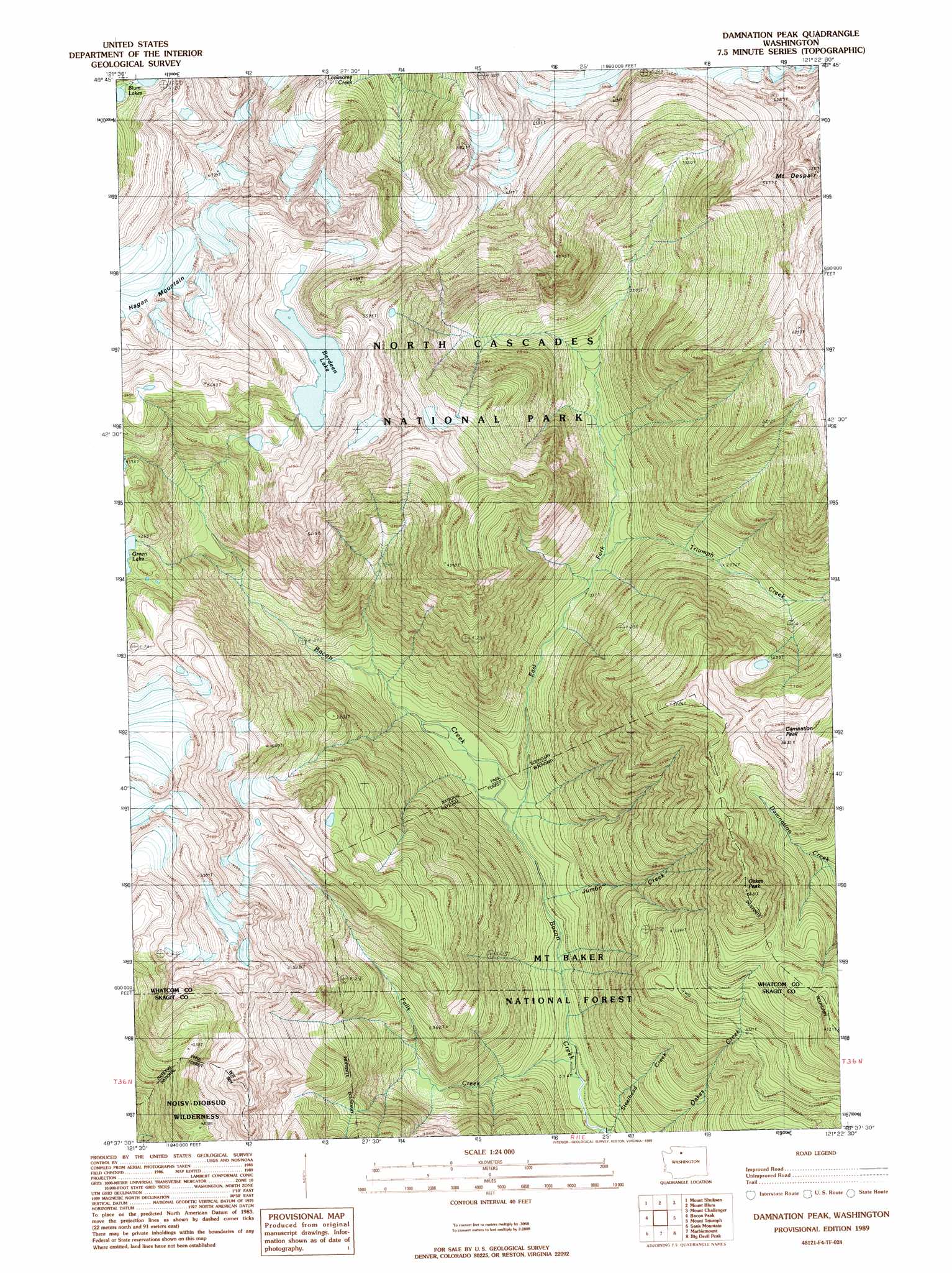
Damnation Peak Topo Map Washington
To zoom in, hover over the map of Damnation Peak
USGS Topo Quad 48121f4 - 1:24,000 scale
| Topo Map Name: | Damnation Peak |
| USGS Topo Quad ID: | 48121f4 |
| Print Size: | ca. 21 1/4" wide x 27" high |
| Southeast Coordinates: | 48.625° N latitude / 121.375° W longitude |
| Map Center Coordinates: | 48.6875° N latitude / 121.4375° W longitude |
| U.S. State: | WA |
| Filename: | o48121f4.jpg |
| Download Map JPG Image: | Damnation Peak topo map 1:24,000 scale |
| Map Type: | Topographic |
| Topo Series: | 7.5´ |
| Map Scale: | 1:24,000 |
| Source of Map Images: | United States Geological Survey (USGS) |
| Alternate Map Versions: |
Damnation Peak WA 1989, updated 1989 Download PDF Buy paper map Damnation Peak WA 1999, updated 2002 Download PDF Buy paper map Damnation Peak WA 2011 Download PDF Buy paper map Damnation Peak WA 2014 Download PDF Buy paper map |
| FStopo: | US Forest Service topo Damnation Peak is available: Download FStopo PDF Download FStopo TIF |
1:24,000 Topo Quads surrounding Damnation Peak
Mount Larrabee |
Mount Sefrit |
Copper Mountain |
Mount Redoubt |
Mount Spickard |
Shuksan Arm |
Mount Shuksan |
Mount Blum |
Mount Challenger |
Mount Prophet |
Welker Peak |
Bacon Peak |
Damnation Peak |
Mount Triumph |
Diablo Dam |
Lake Shannon |
Sauk Mountain |
Marblemount |
Big Devil Peak |
Eldorado Peak |
Finney Peak |
Rockport |
Illabot Peaks |
Snowking Mountain |
Sonny Boy Lakes |
> Back to 48121e1 at 1:100,000 scale
> Back to 48120a1 at 1:250,000 scale
> Back to U.S. Topo Maps home
Damnation Peak topo map: Gazetteer
Damnation Peak: Lakes
Berdeen Lake elevation 1529m 5016′Blum Lakes elevation 1527m 5009′
Triumph Lake elevation 1130m 3707′
Damnation Peak: Streams
East Fork Bacon Creek elevation 272m 892′Falls Creek elevation 184m 603′
Jumbo Creek elevation 242m 793′
Steelhead Creek elevation 177m 580′
Triumph Creek elevation 453m 1486′
Damnation Peak: Summits
Damnation Peak elevation 1703m 5587′Oakes Peak elevation 1714m 5623′
Damnation Peak digital topo map on disk
Buy this Damnation Peak topo map showing relief, roads, GPS coordinates and other geographical features, as a high-resolution digital map file on DVD: