Mount Shuksan Topo Map Washington
To zoom in, hover over the map of Mount Shuksan
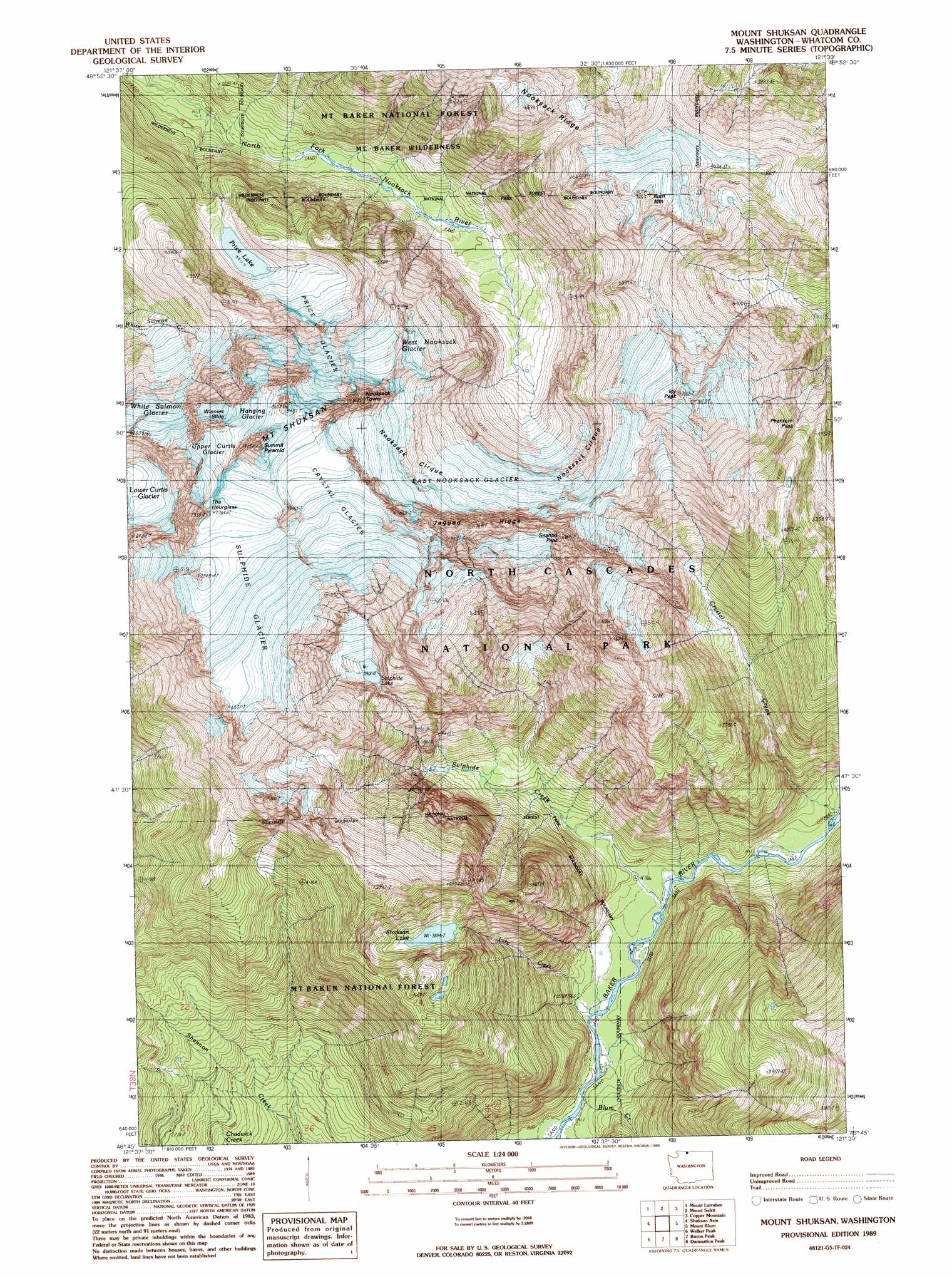
USGS Topo Quad 48121g5 - 1:24,000 scale
| Topo Map Name: | Mount Shuksan |
| USGS Topo Quad ID: | 48121g5 |
| Print Size: | ca. 21 1/4" wide x 27" high |
| Southeast Coordinates: | 48.75° N latitude / 121.5° W longitude |
| Map Center Coordinates: | 48.8125° N latitude / 121.5625° W longitude |
| U.S. State: | WA |
| Filename: | o48121g5.jpg |
| Download Map JPG Image: | Mount Shuksan topo map 1:24,000 scale |
| Map Type: | Topographic |
| Topo Series: | 7.5´ |
| Map Scale: | 1:24,000 |
| Source of Map Images: | United States Geological Survey (USGS) |
| Alternate Map Versions: |
Mount Shuksan WA 1989, updated 1989 Download PDF Buy paper map Mount Shuksan WA 1989, updated 1989 Download PDF Buy paper map Mount Shuksan WA 2011 Download PDF Buy paper map Mount Shuksan WA 2014 Download PDF Buy paper map |
| FStopo: | US Forest Service topo Mount Shuksan is available: Download FStopo PDF Download FStopo TIF |
1:24,000 Topo Quads surrounding Mount Shuksan
Bearpaw Mountain |
Mount Larrabee |
Mount Sefrit |
Copper Mountain |
Mount Redoubt |
Mount Baker |
Shuksan Arm |
Mount Shuksan |
Mount Blum |
Mount Challenger |
Baker Pass |
Welker Peak |
Bacon Peak |
Damnation Peak |
Mount Triumph |
Grandy Lake |
Lake Shannon |
Sauk Mountain |
Marblemount |
Big Devil Peak |
> Back to 48121e1 at 1:100,000 scale
> Back to 48120a1 at 1:250,000 scale
> Back to U.S. Topo Maps home
Mount Shuksan topo map: Gazetteer
Mount Shuksan: Basins
Nooksack Cirque elevation 1804m 5918′Mount Shuksan: Cliffs
Winnies Slide elevation 2143m 7030′Mount Shuksan: Gaps
Phantom Pass elevation 1435m 4708′Mount Shuksan: Glaciers
Crystal Glacier elevation 2361m 7746′East Nooksack Glacier elevation 1633m 5357′
Hanging Glacier elevation 2484m 8149′
Lower Curtis Glacier elevation 1725m 5659′
Price Glacier elevation 1682m 5518′
Sulphide Glacier elevation 2126m 6975′
Upper Curtis Glacier elevation 2305m 7562′
West Nooksack Glacier elevation 1674m 5492′
White Salmon Glacier elevation 1878m 6161′
Mount Shuksan: Lakes
Price Lake elevation 1193m 3914′Shuksan Lake elevation 1127m 3697′
Sulphide Lake elevation 1160m 3805′
Mount Shuksan: Ridges
Jagged Ridge elevation 2283m 7490′Mount Shuksan: Streams
Baker River elevation 250m 820′Blum Creek elevation 242m 793′
Crystal Creek elevation 289m 948′
Lake Creek elevation 247m 810′
Sulphide Creek elevation 265m 869′
Mount Shuksan: Summits
Icy Peak elevation 2102m 6896′Mount Shuksan elevation 2761m 9058′
Nooksack Tower elevation 2530m 8300′
Ruth Mountain elevation 2145m 7037′
Seahpo Peak elevation 2229m 7312′
Summit Pyramid elevation 2761m 9058′
The Hourglass elevation 2345m 7693′
Mount Shuksan digital topo map on disk
Buy this Mount Shuksan topo map showing relief, roads, GPS coordinates and other geographical features, as a high-resolution digital map file on DVD: