Coupeville Topo Map Washington
To zoom in, hover over the map of Coupeville
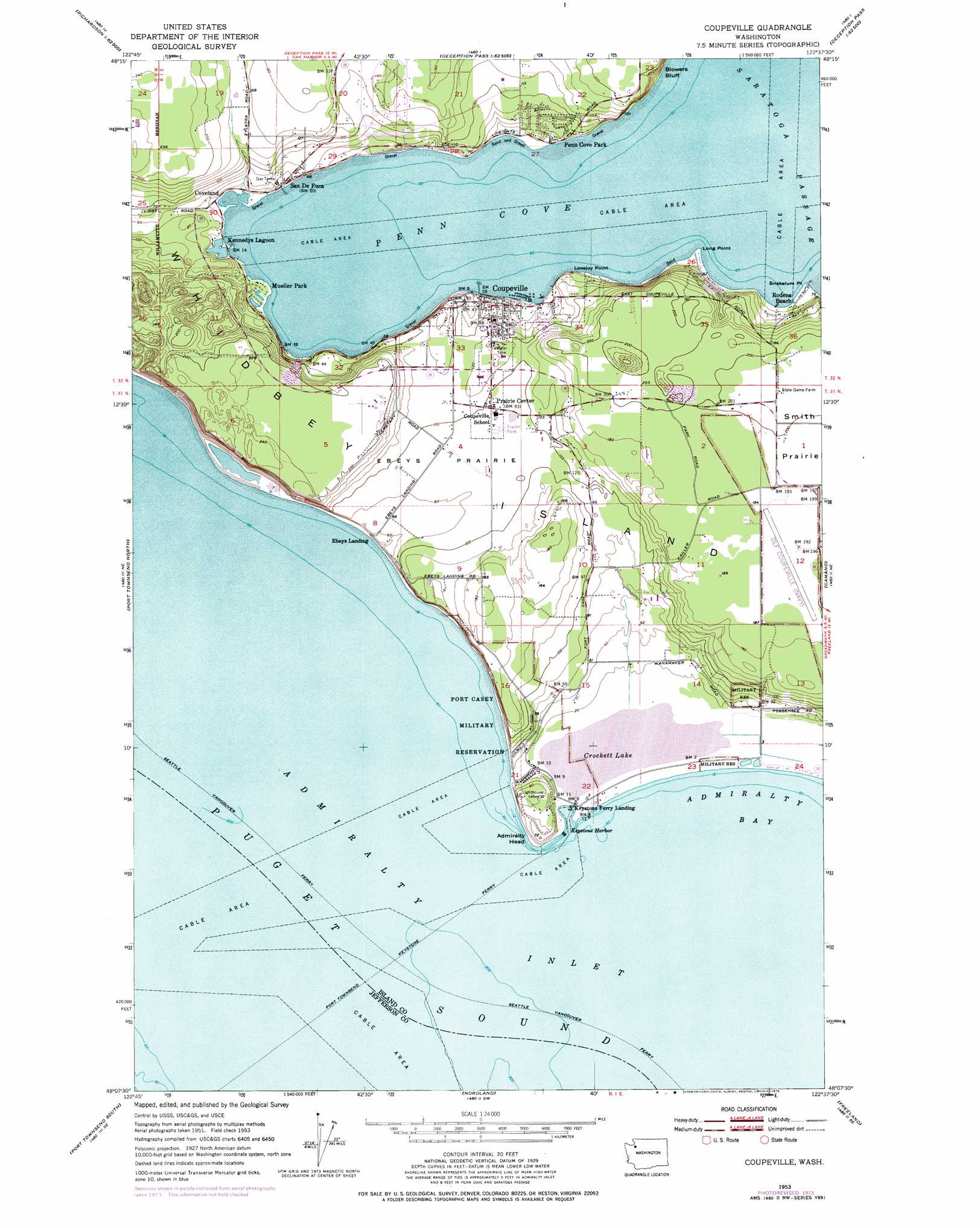
USGS Topo Quad 48122b6 - 1:24,000 scale
| Topo Map Name: | Coupeville |
| USGS Topo Quad ID: | 48122b6 |
| Print Size: | ca. 21 1/4" wide x 27" high |
| Southeast Coordinates: | 48.125° N latitude / 122.625° W longitude |
| Map Center Coordinates: | 48.1875° N latitude / 122.6875° W longitude |
| U.S. State: | WA |
| Filename: | o48122b6.jpg |
| Download Map JPG Image: | Coupeville topo map 1:24,000 scale |
| Map Type: | Topographic |
| Topo Series: | 7.5´ |
| Map Scale: | 1:24,000 |
| Source of Map Images: | United States Geological Survey (USGS) |
| Alternate Map Versions: |
Coupeville WA 1953, updated 1955 Download PDF Buy paper map Coupeville WA 1953, updated 1973 Download PDF Buy paper map Coupeville WA 1953, updated 1976 Download PDF Buy paper map Coupeville WA 2011 Download PDF Buy paper map Coupeville WA 2014 Download PDF Buy paper map |
1:24,000 Topo Quads surrounding Coupeville
Richardson |
Lopez Pass |
Deception Pass |
Anacortes South |
La Conner |
Smith Island |
Oak Harbor |
Crescent Harbor |
Utsalady |
|
Port Townsend North |
Coupeville |
Camano |
Juniper Beach |
|
Gardiner |
Port Townsend South |
Nordland |
Freeland |
Langley |
Uncas |
Center |
Port Ludlow |
Hansville |
Maxwelton |
> Back to 48122a1 at 1:100,000 scale
> Back to 48122a1 at 1:250,000 scale
> Back to U.S. Topo Maps home
Coupeville topo map: Gazetteer
Coupeville: Airports
Coupville Airpark elevation 58m 190′Coupeville: Bars
Keystone Spit elevation 0m 0′Coupeville: Bays
Admiralty Bay elevation 0m 0′Keystone Harbor elevation 0m 0′
Penn Cove elevation 0m 0′
Coupeville: Beaches
Monroe Landing elevation 12m 39′Coupeville: Capes
Admiralty Head elevation 5m 16′Long Point elevation 0m 0′
Lovejoy Point elevation 8m 26′
Snatelum Point elevation -3m -10′
Coupeville: Cliffs
Blowers Bluff elevation 0m 0′Coupeville: Flats
Ebeys Prairie elevation 28m 91′Smith Prairie elevation 62m 203′
Coupeville: Lakes
Crockett Lake elevation 1m 3′Coupeville: Parks
Ebeys Landing National Historical Reserve elevation 41m 134′Coupeville: Populated Places
Captains Choice elevation 21m 68′Coupeville elevation 25m 82′
Coveland elevation 3m 9′
Dean Manor elevation 32m 104′
Ebeys Landing elevation 3m 9′
Fort Casey elevation 3m 9′
Keystone elevation 2m 6′
Keystone Ferry Landing elevation 1m 3′
Penn Cove Park elevation 3m 9′
Port Arthur (historical) elevation 9m 29′
Prairie Center elevation 31m 101′
Rodena Beach elevation 15m 49′
San de Fuca elevation 8m 26′
Sunset Terrace elevation 64m 209′
Coupeville: Springs
Mineral Spring elevation 64m 209′Coupeville digital topo map on disk
Buy this Coupeville topo map showing relief, roads, GPS coordinates and other geographical features, as a high-resolution digital map file on DVD: