Blakely Island Topo Map Washington
To zoom in, hover over the map of Blakely Island
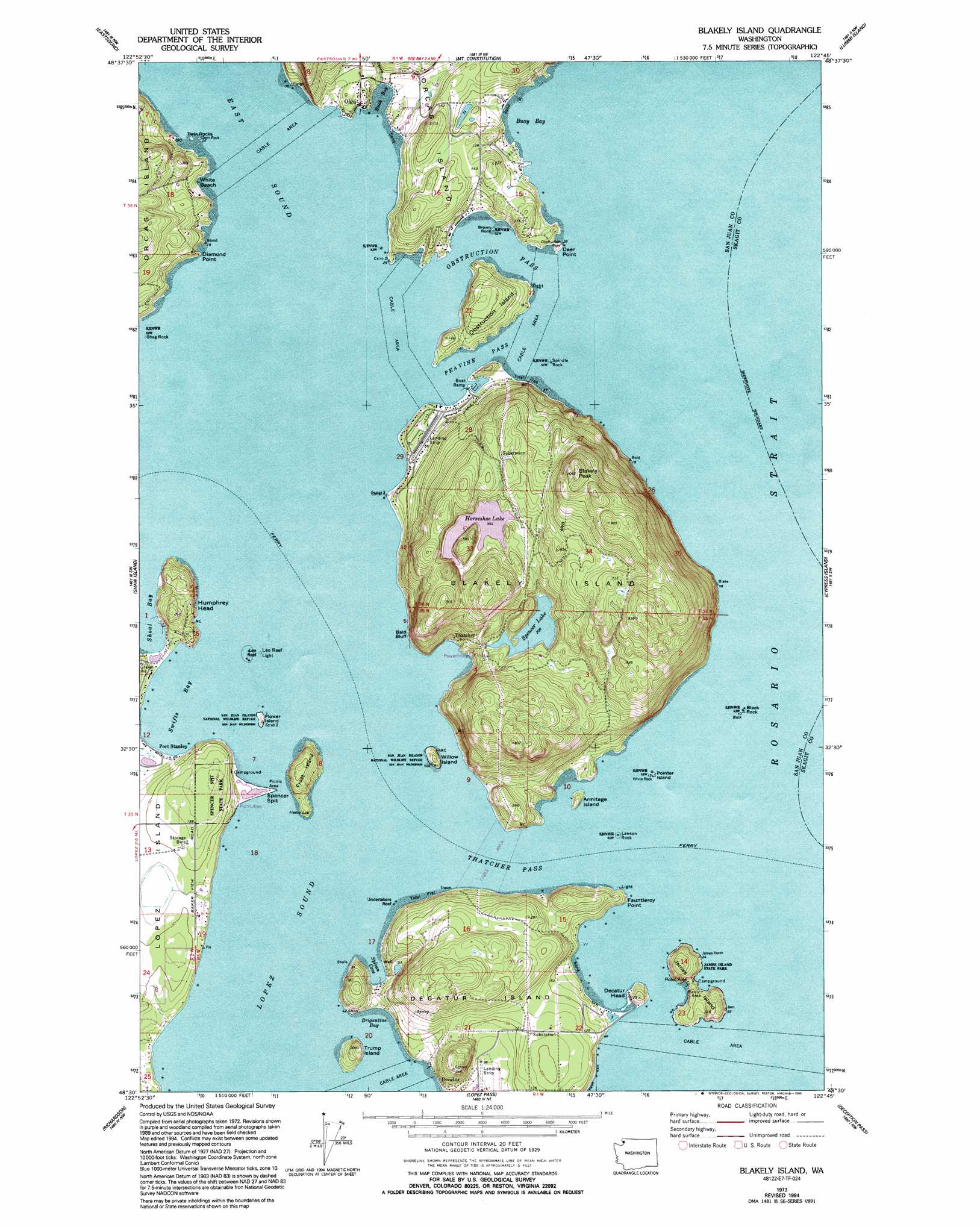
USGS Topo Quad 48122e7 - 1:24,000 scale
| Topo Map Name: | Blakely Island |
| USGS Topo Quad ID: | 48122e7 |
| Print Size: | ca. 21 1/4" wide x 27" high |
| Southeast Coordinates: | 48.5° N latitude / 122.75° W longitude |
| Map Center Coordinates: | 48.5625° N latitude / 122.8125° W longitude |
| U.S. State: | WA |
| Filename: | o48122e7.jpg |
| Download Map JPG Image: | Blakely Island topo map 1:24,000 scale |
| Map Type: | Topographic |
| Topo Series: | 7.5´ |
| Map Scale: | 1:24,000 |
| Source of Map Images: | United States Geological Survey (USGS) |
| Alternate Map Versions: |
Blakely Island WA 1973, updated 1977 Download PDF Buy paper map Blakely Island WA 1973, updated 1991 Download PDF Buy paper map Blakely Island WA 1973, updated 1995 Download PDF Buy paper map Blakely Island WA 1997, updated 2003 Download PDF Buy paper map Blakely Island WA 2011 Download PDF Buy paper map Blakely Island WA 2014 Download PDF Buy paper map |
1:24,000 Topo Quads surrounding Blakely Island
Sucia Island |
Lummi Bay |
Ferndale |
||
Waldron Island |
Eastsound |
Mount Constitution |
Lummi Island |
Eliza Island |
Friday Harbor |
Shaw Island |
Blakely Island |
Cypress Island |
Anacortes North |
False Bay |
Richardson |
Lopez Pass |
Deception Pass |
Anacortes South |
Smith Island |
Oak Harbor |
Crescent Harbor |
> Back to 48122e1 at 1:100,000 scale
> Back to 48122a1 at 1:250,000 scale
> Back to U.S. Topo Maps home
Blakely Island topo map: Gazetteer
Blakely Island: Airports
Blakely Island Airport elevation 23m 75′Decatur Shores Airport elevation 4m 13′
Decatur-Jones Airport elevation 41m 134′
Deer Point Airport elevation 47m 154′
Blakely Island: Bars
Blakely Island Shoal elevation 0m 0′Lawson Rock elevation 0m 0′
Lydia Shoal elevation 0m 0′
Spencer Spit elevation 2m 6′
Spindle Rock elevation 0m 0′
Undertakers Reef elevation 0m 0′
Undertakers Reef elevation 0m 0′
Blakely Island: Bays
Brigantine Bay elevation 0m 0′Buck Bay elevation 0m 0′
Buoy Bay elevation 0m 0′
Davis Bay elevation 0m 0′
East Sound elevation 0m 0′
Swifts Bay elevation 0m 0′
Sylvan Cove elevation 0m 0′
Thatcher Bay elevation 0m 0′
Blakely Island: Beaches
Green Bank elevation 0m 0′White Beach elevation 24m 78′
Blakely Island: Capes
Deer Point elevation 7m 22′Diamond Point elevation 7m 22′
Fauntleroy Point elevation 7m 22′
Blakely Island: Channels
Obstruction Pass elevation 68m 223′Peavine Pass elevation 0m 0′
Rosario Strait elevation 0m 0′
Thatcher Pass elevation 0m 0′
Blakely Island: Cliffs
Bald Bluff elevation 59m 193′Humphrey Head elevation 0m 0′
Blakely Island: Dams
Turek Dam elevation 28m 91′Blakely Island: Islands
Armitage Island elevation 28m 91′Black Rock elevation 0m 0′
Blakely Island elevation 125m 410′
Decatur Island elevation 24m 78′
Flower Island elevation 12m 39′
Frost Island elevation 62m 203′
James Island elevation 22m 72′
Obstruction Island elevation 70m 229′
Pointer Island elevation 3m 9′
The Pointers elevation 0m 0′
Trump Island elevation 44m 144′
Twin Rocks elevation 3m 9′
Willow Island elevation 30m 98′
Blakely Island: Lakes
Horseshoe Lake elevation 109m 357′Spencer Lake elevation 65m 213′
Blakely Island: Parks
James Island State Park elevation 22m 72′Olga Marine State Park elevation 14m 45′
Spencer Spit State Park elevation 47m 154′
Blakely Island: Populated Places
Decatur elevation 24m 78′Olga elevation 11m 36′
Port Stanley elevation 3m 9′
Thatcher elevation 22m 72′
Blakely Island: Streams
Cascade Creek elevation 2m 6′Blakely Island: Summits
Blakely Peak elevation 319m 1046′Brown Rock elevation 3m 9′
Decatur Head elevation 39m 127′
San Elmo elevation 164m 538′
Blakely Island digital topo map on disk
Buy this Blakely Island topo map showing relief, roads, GPS coordinates and other geographical features, as a high-resolution digital map file on DVD: