Eliza Island Topo Map Washington
To zoom in, hover over the map of Eliza Island
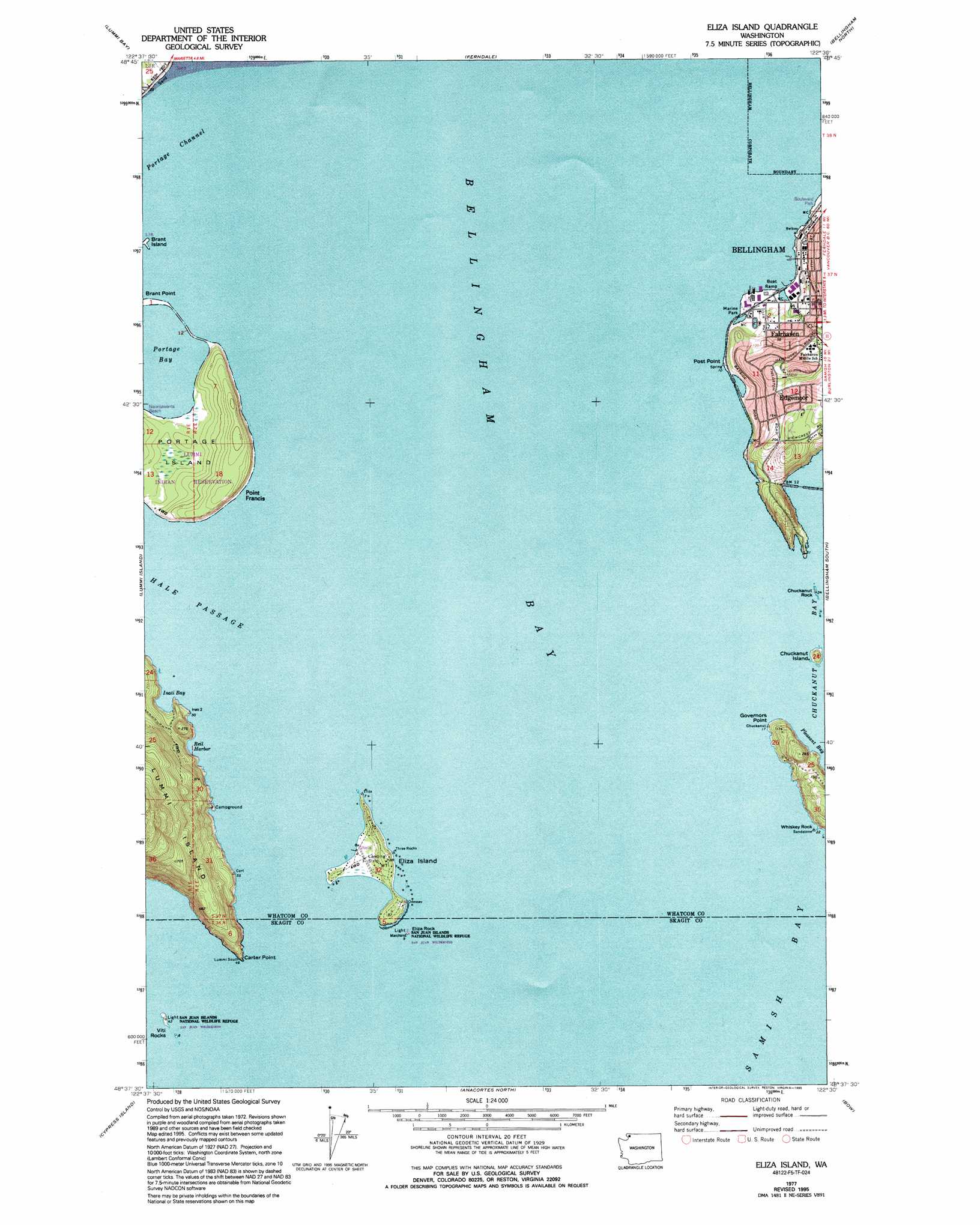
USGS Topo Quad 48122f5 - 1:24,000 scale
| Topo Map Name: | Eliza Island |
| USGS Topo Quad ID: | 48122f5 |
| Print Size: | ca. 21 1/4" wide x 27" high |
| Southeast Coordinates: | 48.625° N latitude / 122.5° W longitude |
| Map Center Coordinates: | 48.6875° N latitude / 122.5625° W longitude |
| U.S. State: | WA |
| Filename: | o48122f5.jpg |
| Download Map JPG Image: | Eliza Island topo map 1:24,000 scale |
| Map Type: | Topographic |
| Topo Series: | 7.5´ |
| Map Scale: | 1:24,000 |
| Source of Map Images: | United States Geological Survey (USGS) |
| Alternate Map Versions: |
Eliza Island WA 1977, updated 1977 Download PDF Buy paper map Eliza Island WA 1977, updated 1995 Download PDF Buy paper map Eliza Island WA 1998, updated 2003 Download PDF Buy paper map Eliza Island WA 2011 Download PDF Buy paper map Eliza Island WA 2014 Download PDF Buy paper map |
1:24,000 Topo Quads surrounding Eliza Island
Birch Point |
Blaine |
Bertrand Creek |
Lynden |
Sumas |
Lummi Bay |
Ferndale |
Bellingham North |
Lawrence |
|
Mount Constitution |
Lummi Island |
Eliza Island |
Bellingham South |
Lake Whatcom |
Blakely Island |
Cypress Island |
Anacortes North |
Bow |
Alger |
Lopez Pass |
Deception Pass |
Anacortes South |
La Conner |
Mount Vernon |
> Back to 48122e1 at 1:100,000 scale
> Back to 48122a1 at 1:250,000 scale
> Back to U.S. Topo Maps home
Eliza Island topo map: Gazetteer
Eliza Island: Airports
Eliza Island Airport elevation 7m 22′Eliza Island: Bars
Chuckanut Rock elevation 0m 0′Eliza Rock elevation 0m 0′
Starr Rock elevation 0m 0′
Eliza Island: Bays
Bellingham Bay elevation 0m 0′Inati Bay elevation 0m 0′
Pleasant Bay elevation 0m 0′
Portage Bay elevation 0m 0′
Eliza Island: Capes
Carter Point elevation 0m 0′Governors Point elevation 25m 82′
Point Francis elevation 17m 55′
Post Point elevation 41m 134′
Eliza Island: Harbors
Reil Harbor elevation 20m 65′Eliza Island: Islands
Chuckanut Island elevation 0m 0′Eliza Island elevation 13m 42′
Portage Island elevation 9m 29′
Viti Rocks elevation 0m 0′
Eliza Island: Parks
Port of Bellingham Marine Park elevation 2m 6′Eliza Island: Pillars
Whiskey Rock elevation 0m 0′Eliza Island: Populated Places
Edgemoor elevation 56m 183′Fairhaven elevation 8m 26′
Eliza Island: Streams
Padden Creek elevation 4m 13′Eliza Island: Summits
Three Rocks elevation 0m 0′Eliza Island digital topo map on disk
Buy this Eliza Island topo map showing relief, roads, GPS coordinates and other geographical features, as a high-resolution digital map file on DVD: