Lummi Island Topo Map Washington
To zoom in, hover over the map of Lummi Island
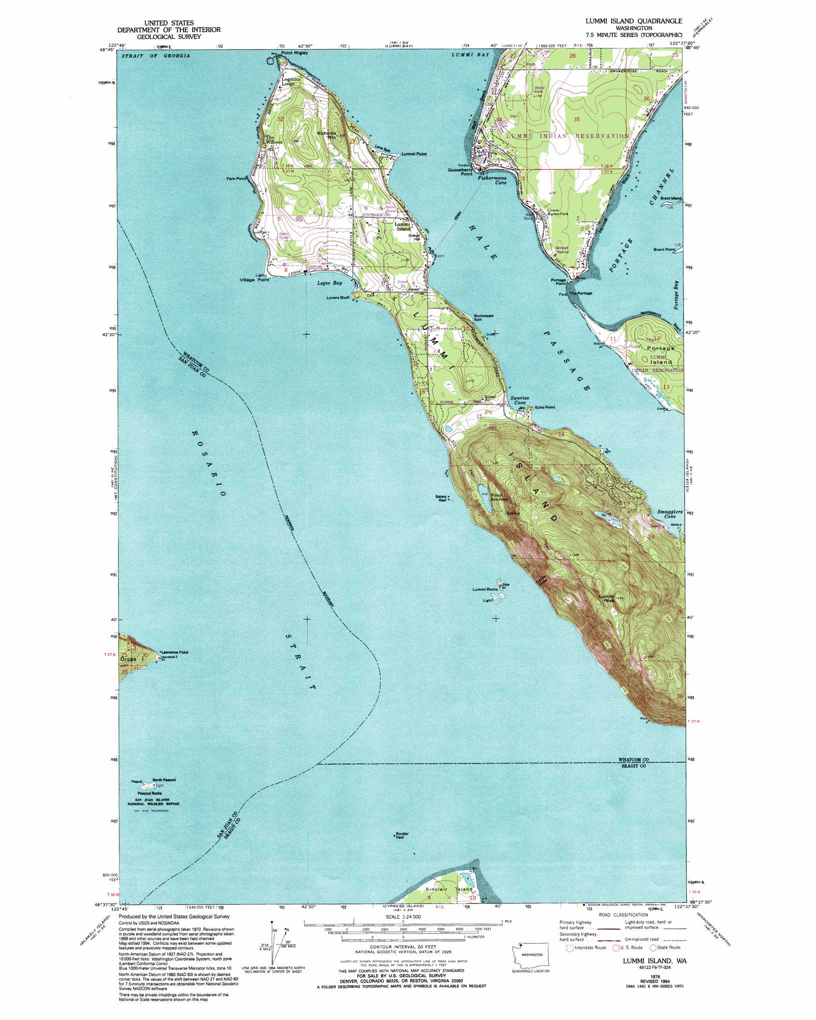
USGS Topo Quad 48122f6 - 1:24,000 scale
| Topo Map Name: | Lummi Island |
| USGS Topo Quad ID: | 48122f6 |
| Print Size: | ca. 21 1/4" wide x 27" high |
| Southeast Coordinates: | 48.625° N latitude / 122.625° W longitude |
| Map Center Coordinates: | 48.6875° N latitude / 122.6875° W longitude |
| U.S. State: | WA |
| Filename: | o48122f6.jpg |
| Download Map JPG Image: | Lummi Island topo map 1:24,000 scale |
| Map Type: | Topographic |
| Topo Series: | 7.5´ |
| Map Scale: | 1:24,000 |
| Source of Map Images: | United States Geological Survey (USGS) |
| Alternate Map Versions: |
Lummi Island WA 1978, updated 1978 Download PDF Buy paper map Lummi Island WA 1978, updated 1995 Download PDF Buy paper map Lummi Island WA 1998, updated 2003 Download PDF Buy paper map Lummi Island WA 2011 Download PDF Buy paper map Lummi Island WA 2014 Download PDF Buy paper map |
1:24,000 Topo Quads surrounding Lummi Island
Birch Point |
Blaine |
Bertrand Creek |
Lynden |
|
Sucia Island |
Lummi Bay |
Ferndale |
Bellingham North |
|
Eastsound |
Mount Constitution |
Lummi Island |
Eliza Island |
Bellingham South |
Shaw Island |
Blakely Island |
Cypress Island |
Anacortes North |
Bow |
Richardson |
Lopez Pass |
Deception Pass |
Anacortes South |
La Conner |
> Back to 48122e1 at 1:100,000 scale
> Back to 48122a1 at 1:250,000 scale
> Back to U.S. Topo Maps home
Lummi Island topo map: Gazetteer
Lummi Island: Airports
Millers Field elevation 48m 157′Lummi Island: Bars
Bakers Reef elevation 0m 0′Boulder Reef elevation 0m 0′
Lummi Island: Bays
Fishermans Cove elevation 0m 0′Legoe Bay elevation 0m 0′
Smugglers Cove elevation 20m 65′
Sunrise Cove elevation 8m 26′
Lummi Island: Beaches
Hermosa Beach elevation 0m 0′Neontawanta Beach elevation 0m 0′
West Beach elevation 0m 0′
Lummi Island: Capes
Brant Point elevation 2m 6′Bumstead Spit elevation 4m 13′
Echo Point elevation 0m 0′
Fern Point elevation 0m 0′
Gooseberry Point elevation 2m 6′
Lane Spit elevation 4m 13′
Lawrence Point elevation 0m 0′
Lummi Point elevation 2m 6′
Point Migley elevation 10m 32′
Portage Point elevation 0m 0′
Village Point elevation 1m 3′
Lummi Island: Channels
Hale Passage elevation 0m 0′Portage Channel elevation 0m 0′
The Portage elevation 0m 0′
Lummi Island: Cliffs
Devils Slide elevation 59m 193′Lovers Bluff elevation 0m 0′
Lummi Island: Dams
Brown Dam elevation 45m 147′Holiday Lake Dam elevation 199m 652′
Lummi Island Est. Dam elevation 153m 501′
Lummi Island: Islands
Brant Island elevation 0m 0′Lummi Island elevation 13m 42′
Lummi Rocks elevation 11m 36′
North Peapod elevation 6m 19′
Lummi Island: Parks
Lummi Marine Park elevation 4m 13′Lummi Island: Pillars
Lummi Peak elevation 505m 1656′Lummi Island: Populated Places
Beach elevation 8m 26′Lummi Island elevation 19m 62′
Lummi Island: Reservoirs
Baker Reservoir elevation 126m 413′Holiday Lake elevation 199m 652′
Lummi Island: Summits
Richards Mountain elevation 101m 331′Lummi Island digital topo map on disk
Buy this Lummi Island topo map showing relief, roads, GPS coordinates and other geographical features, as a high-resolution digital map file on DVD: