Sequim Topo Map Washington
To zoom in, hover over the map of Sequim
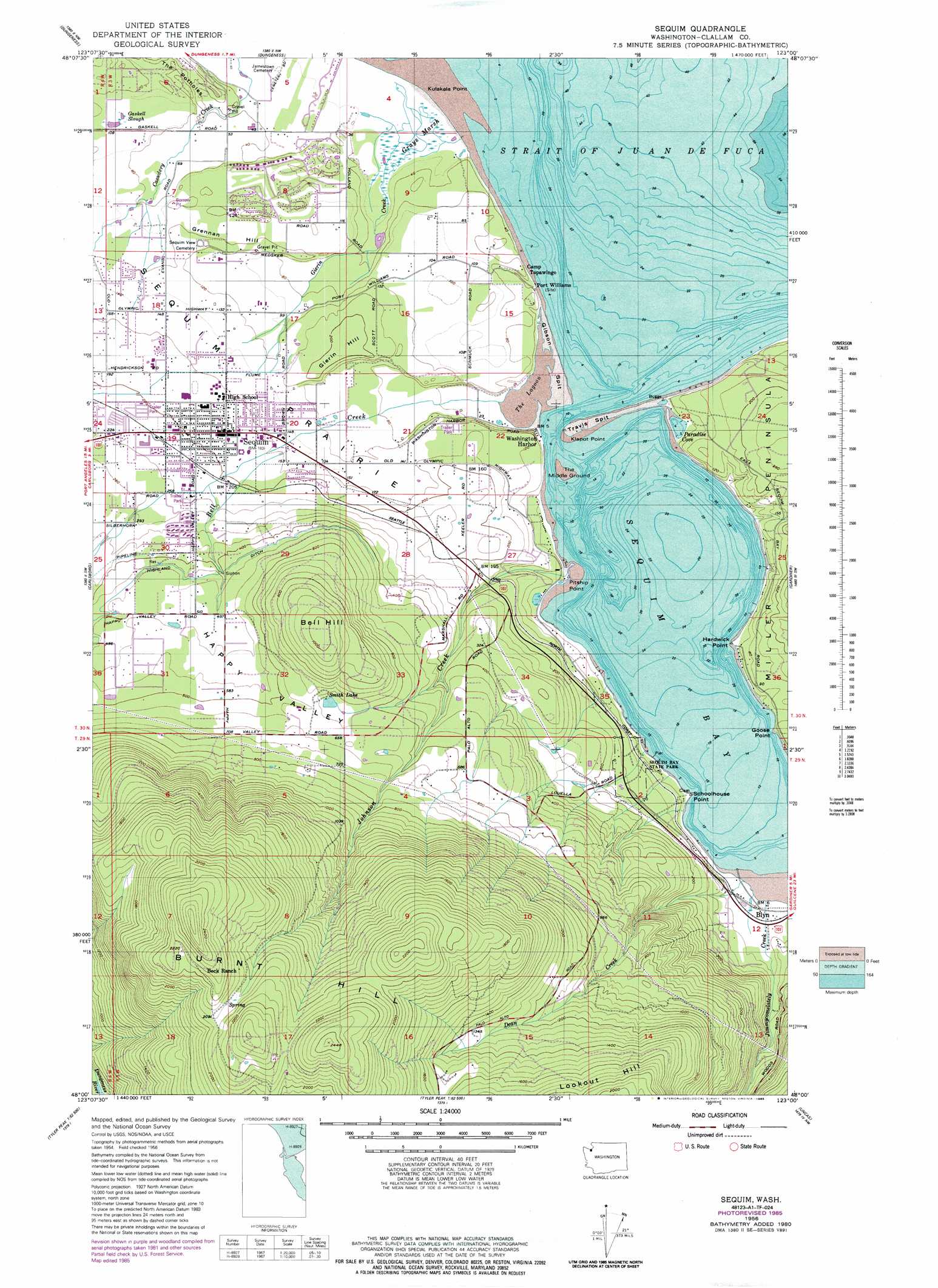
USGS Topo Quad 48123a1 - 1:24,000 scale
| Topo Map Name: | Sequim |
| USGS Topo Quad ID: | 48123a1 |
| Print Size: | ca. 21 1/4" wide x 27" high |
| Southeast Coordinates: | 48° N latitude / 123° W longitude |
| Map Center Coordinates: | 48.0625° N latitude / 123.0625° W longitude |
| U.S. State: | WA |
| Filename: | o48123a1.jpg |
| Download Map JPG Image: | Sequim topo map 1:24,000 scale |
| Map Type: | Topographic |
| Topo Series: | 7.5´ |
| Map Scale: | 1:24,000 |
| Source of Map Images: | United States Geological Survey (USGS) |
| Alternate Map Versions: |
Sequim WA 1956, updated 1957 Download PDF Buy paper map Sequim WA 1956, updated 1965 Download PDF Buy paper map Sequim WA 1956, updated 1970 Download PDF Buy paper map Sequim WA 1956, updated 1981 Download PDF Buy paper map Sequim WA 1956, updated 1986 Download PDF Buy paper map Sequim WA 2011 Download PDF Buy paper map Sequim WA 2014 Download PDF Buy paper map |
| FStopo: | US Forest Service topo Sequim is available: Download FStopo PDF Download FStopo TIF |
1:24,000 Topo Quads surrounding Sequim
Smith Island |
||||
Dungeness |
Port Townsend North |
|||
Morse Creek |
Carlsborg |
Sequim |
Gardiner |
Port Townsend South |
Maiden Peak |
Tyler Peak |
Mount Zion |
Uncas |
Center |
Wellesley Peak |
Mount Deception |
Mount Townsend |
Mount Walker |
Quilcene |
> Back to 48123a1 at 1:100,000 scale
> Back to 48122a1 at 1:250,000 scale
> Back to U.S. Topo Maps home
Sequim topo map: Gazetteer
Sequim: Airports
Davis Field elevation 34m 111′Duke's Private Airport elevation 50m 164′
Harbord Field elevation 7m 22′
O M H Airport elevation 61m 200′
Oak Harbor Air Park elevation 61m 200′
Sequim: Bars
Gibson Spit elevation 1m 3′Travis Spit elevation 2m 6′
Sequim: Bays
Paradise Cove elevation 2m 6′Sequim Bay elevation 2m 6′
Sequim: Capes
Goose Point elevation 1m 3′Hardwick Point elevation 3m 9′
Kiapot Point elevation 23m 75′
Klapot Point elevation 3m 9′
Kulakala Point elevation 2m 6′
Pitship Point elevation 1m 3′
Schoolhouse Point elevation 2m 6′
Sequim: Flats
Sequim Prairie elevation 45m 147′Sequim: Islands
The Middle Ground elevation 1m 3′Sequim: Lakes
Smith Lake elevation 195m 639′The Lagoon elevation 2m 6′
Sequim: Parks
Sequim Bay State Park elevation 36m 118′Sequim: Populated Places
Bell Hill elevation 311m 1020′Blyn elevation 3m 9′
Happy Valley elevation 169m 554′
Port Williams elevation 2m 6′
Sequim elevation 55m 180′
Washington Harbor elevation 1m 3′
Sequim: Streams
Bell Creek elevation 1m 3′Dean Creek elevation 2m 6′
Gaskell Slough elevation 33m 108′
Gierin Creek elevation 2m 6′
Jimmycomelately Creek elevation 3m 9′
Johnson Creek elevation 2m 6′
Sequim: Summits
Bell Hill elevation 315m 1033′Burnt Hill elevation 680m 2230′
Gierin Hill elevation 72m 236′
Grennan Hill elevation 41m 134′
Lookout Hill elevation 574m 1883′
Sequim: Swamps
Grays Marsh elevation 2m 6′Sequim digital topo map on disk
Buy this Sequim topo map showing relief, roads, GPS coordinates and other geographical features, as a high-resolution digital map file on DVD: