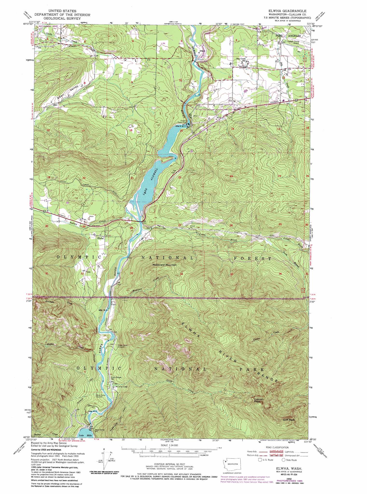
Elwha Topo Map Washington
To zoom in, hover over the map of Elwha
USGS Topo Quad 48123a5 - 1:24,000 scale
| Topo Map Name: | Elwha |
| USGS Topo Quad ID: | 48123a5 |
| Print Size: | ca. 21 1/4" wide x 27" high |
| Southeast Coordinates: | 48° N latitude / 123.5° W longitude |
| Map Center Coordinates: | 48.0625° N latitude / 123.5625° W longitude |
| U.S. State: | WA |
| Filename: | o48123a5.jpg |
| Download Map JPG Image: | Elwha topo map 1:24,000 scale |
| Map Type: | Topographic |
| Topo Series: | 7.5´ |
| Map Scale: | 1:24,000 |
| Source of Map Images: | United States Geological Survey (USGS) |
| Alternate Map Versions: |
Elwha WA 1950, updated 1955 Download PDF Buy paper map Elwha WA 1950, updated 1976 Download PDF Buy paper map Elwha WA 1950, updated 1979 Download PDF Buy paper map Elwha WA 1950, updated 1985 Download PDF Buy paper map Elwha WA 1950, updated 1985 Download PDF Buy paper map Elwha WA 2011 Download PDF Buy paper map Elwha WA 2014 Download PDF Buy paper map |
| FStopo: | US Forest Service topo Elwha is available: Download FStopo PDF Download FStopo TIF |
1:24,000 Topo Quads surrounding Elwha
Disque |
Joyce |
Angeles Point |
Ediz Hook |
|
Lake Crescent |
Lake Sutherland |
Elwha |
Port Angeles |
Morse Creek |
Bogachiel Peak |
Mount Carrie |
Hurricane Hill |
Mount Angeles |
Maiden Peak |
Mount Tom |
Mount Olympus |
Mount Queets |
Mccartney Peak |
Wellesley Peak |
> Back to 48123a1 at 1:100,000 scale
> Back to 48122a1 at 1:250,000 scale
> Back to U.S. Topo Maps home
Elwha topo map: Gazetteer
Elwha: Dams
Elwha Dam elevation 44m 144′Upper Elwha Dam elevation 166m 544′
Elwha: Forests
Pacific Ranger District elevation 750m 2460′Elwha: Populated Places
Elwha elevation 132m 433′Elwha: Ranges
Elwha River Range elevation 1404m 4606′Elwha: Reservoirs
Lake Aldwell elevation 32m 104′Lake Mills elevation 166m 544′
Elwha: Streams
Chickamin Creek elevation 67m 219′Freeman Creek elevation 84m 275′
Griff Creek elevation 99m 324′
Hughes Creek elevation 99m 324′
Indian Creek elevation 62m 203′
Little River elevation 63m 206′
Madison Creek elevation 77m 252′
South Branch Little River elevation 211m 692′
Elwha: Summits
Griff Peak elevation 1560m 5118′McDonald Mountain elevation 652m 2139′
McDonald Mountain elevation 652m 2139′
Unicorn Peak elevation 1553m 5095′
Elwha: Valleys
Eden Valley elevation 100m 328′Elwha digital topo map on disk
Buy this Elwha topo map showing relief, roads, GPS coordinates and other geographical features, as a high-resolution digital map file on DVD: