Map Center of Kaysville topo map
Interactive topo map of Map Center of Kaysville, UT
| Place Name: | Map Center of Kaysville |
| Feature Class: | Topo Map |
| Country: | United States |
| Latitude: | 41.0625 |
| Longitude: | -111.9375 |
| USGS Quad: | Kaysville topo map |
| 7.5´ topo: | 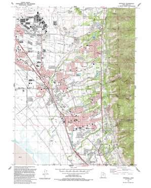 |
| State topo index: | UT topo index |
| Alternate map versions: | UT topographic maps Editions by year, direct download as GeoPDF. |
| 30´ x 60´ topo: | 1:100,000 scale map |
| 1° x 2° topo: | 1:250,000 scale map |
- Adams Canyon
- Adams Reservoir
- Corbett Creek
- East Layton
- Fruit Heights
- Haight Bench Canal
- Hobbs Canyon
- Hobbs Reservoir
- Holmes Creek
- Holmes Reservoir
- Kaysville
- Layton
- Laytona
- Middle Fork Kays Creek
- North Farmington Junction
- North Fork Holmes Creek
- North Fork Kays Creek
- Sahara Village
- Shepard Creek
- Snow Creek
- South Fork Kays Creek
- Webb Canyon
- West Kaysville
- West Layton
- Galbraith Airport
- Barton Ponds Park
- Bishop Field
- East Wilderness Park
- Gailey Park
- Humana Hospital Davis North Heliport
- Richmond Park
- Bair Canyon
- Country Oaks Condominium
- Dimond Oaks
- Hidden Hideaway Condominium
- Sundowner Condominium
- Fairfield Condominium
- Layton Meadows Condominium
- Layton Park Plaza Condominium
- Meadow Creek Condominium
- Nayon Heights Condominium
- Property Consultants Condominium
- Townhouse Condominium
- Fort Lane Plaza Condominium
- Marketboro Condostor Condominium
- Meadow Hollow Condominium
- Meadows at Mutton Hollow Condominium
- Somerset Place Condominium
- Oakridge Village Condominium
- Cook
- Marketboro
- Aura Acres
- Avion Vista
- Chapel Hill
- Clarinda
- Clair Black
- Cottonwood
- Country Hollow
- Country Oaks
- Dawn Development
- Deerfield
- Diamond Oaks
- Dreams End
- Eastridge Estates
- Heatherglen
- Hidden Hollow
- Hillside Estates
- Indians Hills
- Kays Creek
- LaDonna Mesa
- Lakeland
- Lakeview Mobile Home Park
- McDonald
- Natural Estates
- Norager Acres
- North Hills Estates
- Oak Forest One
- Oak Forest Two
- Oak Hill
- Oak Hollow
- Phyllis
- Pleasant Hills
- Quail Creek
- Quail Hollow
- Quail Point
- Rachels Place
- Robinwood
- Rolling Oaks
- Snow Canyon
- Tri Oaks
- Valley Hi
- Victorian Oaks
- Walker
- Wooded Hills
- Aspen East
- Camelot
- Cherry Lane Heights
- Church Hills
- Church Hill Estates
- Church Street
- Colonies of East Pointe
- Diamond Hills
- East Meadow
- East Layton Hills
- Eastwood Estates
- Farifield Park
- Fort Lane
- Gill
- Glendale Gardens
- Golden Acres
- Green Leaf Meadows
- Heather Hills
- Hill Villa
- Holt
- Homeplace
- Jamestown
- Jo Lu
- Kens
- Kimberly Meadows
- King
- Lakewood
- Mala
- Maple Acres
- Marshall Heights
- Meadowbrook Hollow
- Mount Air Estates
- Nalder Heights
- Parkdale
- Ridge Crest Estates
- Ridgeview Park
- Riley
- Robins Park
- Robins Park One and Two
- Rogers Park
- Rosmait Park
- Simmons
- Skyline Addition
- Spring Hollow
- Summerfield
- Village Green
- Wasatch Heights
- Abrams Way
- Aspen Heights
- Barker
- Barnes Estates
- Brook Haven
- Brookhurst
- Carrie Heights
- Chantilly Square
- Clover Estates
- Colonial Park
- Country Creek Estates
- Country Estates
- Country Meadows
- Creekside
- Cresthomes Addition
- Crestwood Acres
- East Crest Estates
- Eastridge
- Eastview
- Ellison
- Fairfield Estates
- Fairfield Farm Estates
- Fernwood Hollow
- Grand Oaks
- Green Briar West
- Green Lawns
- Haven Park
- Hob Hill
- Hods Hollow
- Hodson Estates
- Holmes Creek Estates
- Holmes Hollow Estates
- Indian Oaks
- Island View Acres
- Johns Acres
- Jones
- Kaysville Heights
- Kent Estates
- King Clarion Hills
- Lake Hills
- Leedot Heights
- Millcreek Estates
- Morgan Farms
- Mount Dell
- Mountain Terrace Estates
- Mountain View
- Mutton Hollow Acres
- Mutton Hollow Meadows
- Oak Lane Heights
- Oakmont Acres
- Oakridge Terrace
- Peach Tree
- Phillips
- Quail Ridge
- Rosewood
- Roueche Hills
- Ruby Acres
- Snow Creek
- Spurlock Circle
- Summer Haze
- Tanglewood
- Tiffany Park
- Twin Creek Estates
- Vallee Villa
- Vantage Park
- Vera Lee
- Victory Park
- View Heights
- Wheat Ridge
- Whitesides Estates
- Woodridge Estates
- Canyon Cove Estates
- Cherry Farm Estates
- Deer Run Estates
- Koziar Hills
- Peachwood Estates
- Royal Farms Estates
- Royal Oaks
- Alta Acres
- Barton Manor One
- Barton Manor Two
- Barton Manor Three
- Calder Hill
- Cherry View
- Cherrywood
- Creek View Estates
- East Oaks
- Foster-Grant
- Four Corners
- Green Mountain Estates
- Green Oaks Estates
- Harvey Farm Estates
- Heath
- Park Heights
- Park View Estates
- Pilly Green
- Rolling Greens
- Tamara Estates
- Upland
- Woodridge Twin Homes
- Cameron Estates
- Country Lane
- David Smith
- Fairway Fields
- Farmington Orchards
- Gailey
- Green View
- Happy Home Five
- Happy Homes
- Hen Farm Estates
- Kay Lyn Manor
- King Farm Estates
- Lupine Village
- Misty Meadows
- Moon Park
- Oakridge Farms
- Oakridge Highlands
- Oakridge Place
- Oakridge Village
- Palos Verde Estates
- Shanna
- Shepherd Creek County Estates
- Somerset Farm
- Sommerset Hollow
- Spencer Estates
- Summer Wood
- The Meadows
- The Oaks at Mutton Hollow
- The Orchard
- Fernwood Recreation Site
- Kaysville Post Office
- Layton Post Office
- Interchange 331
- Interchange 332
- Interchange 334
- Interchange 335
- Layton Heritage Museum Ed Kenly Centennial Amphitheater
- Oak Forest Park
- Vae View Park