USGS topographic maps
View 55,000+ United States Geological Survey topo maps online - buy paper maps
Click on your area of choice on the map below to see the 1:250,000 scale topo map. You can then navigate through to 1:100,000 scale and 1:24,000 scale maps for all 48 contiguous U.S. states. These maps are available for online viewing, and purchase as USGS paper maps, and digital collections of map images on DVD.
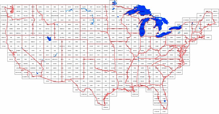
To identify the map sheets you need, download the index maps:
1:250,000 topo index map (large version of the above)
1:100,000 topo index map
Overview of USGS Topo Maps
The United States Geological Survey (USGS) topographic maps which you can view here online are available on regular paper and waterproof material, starting at $8.95.
USGS topographic maps generally come in 3 scales:
- 1:250,000 scale
- 1:100,000 scale
- 1:24,000 scale (sometimes 1:25,000 scale)
Paper maps are available for all scales.
1:250,000 scale topographic maps
Maps at 1:250,000 scale cover a large area and give a good general overview of topography and populated places. The contiguous United States are covered by a total of ca. 470 maps at this scale. This smaller scale is often used for canoe expeditions, or other activities where great distances are crossed, while high terrain detail is not necessarily required.
1:100,000 scale topographic maps
The 1:100,000 scale maps produced by USGS provide more detail than a 1:250,000 scale map, but less detail than a 1:24,000 scale map. The area covered by one 1:250,000 scale map requires a total of four 1:100,000 scale topo maps. The contiguous United States are covered by a total of ca. 1840 maps at this scale.
1:24,000 scale topographic maps
1:24,000 is the primary large-scale topographic map series published by the United States Geological Survey. These maps show high terrain detail, and are very useful for all sorts of applications and outdoor activities. In some rare areas, these maps are published at 1:25,000 scale and cover roughly the size of two 1:24,000 scale maps. You do not have a choice between the similar scales of 1:24,000 and 1:25,000 - each area is covered by either scale only. There are more than 53,300 maps available at these scales for the contiguous United States.
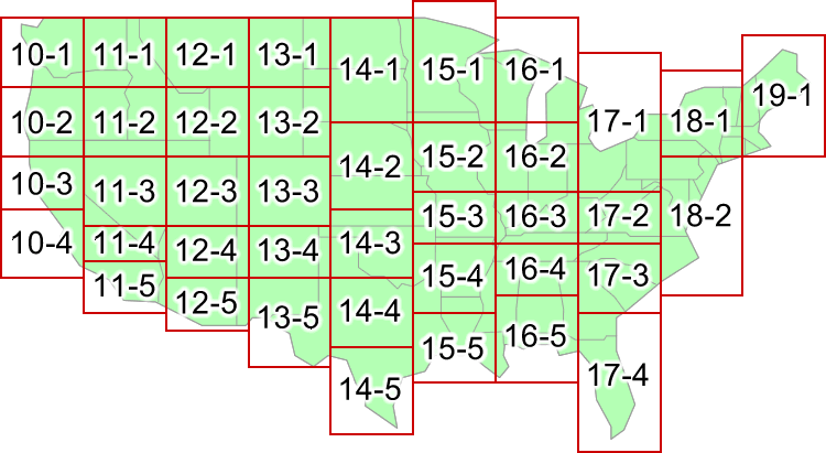
U.S. Topo Map Collections on DVD (1:24,000 Series)
Purchase collections of thousands of digital topographic maps on Data-DVD. The maps are Digital Raster Graphics (DRGs) produced by the U.S. Geological Survey (USGS). The map images found on these disks are in GIF image format at a scale of 1:24,000 and 1:25,000.


Click through the map below to purchase specific Topo DVD volumes.
Digital Topo maps of Alaska
Topographic maps of Alaska are available as digital image files at 1:250,000 and 1:63,360 scale on two data-DVD disks.


Topo maps of Hawaii
Hawaii topographic maps are not currently available on this website. However, you can contact us directly to obtain map indexes and buy these paper topo maps from us.