02S51E21ACBB01 Well, MT
Interactive topo map of 02S51E21ACBB01 Well, MT
| Place Name: | 02S51E21ACBB01 Well |
| Feature Class: | Well |
| US State: | MT |
| County: | Powder River |
| Latitude: | 45.65 |
| Longitude: | -105.43 |
| Elevation (meters): | 940 m |
| Elevation (feet): | 3083′ |
| USGS Quad: | Johnnie Creek topo map |
| 7.5´ topo: | 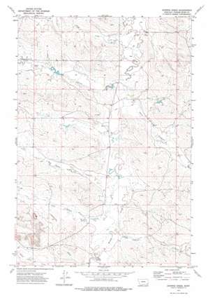 |
| State topo index: | MT topo index |
| Alternate map versions: | MT topographic maps Editions by year, direct download as GeoPDF. |
| 30´ x 60´ topo: | 1:100,000 scale map |
| 1° x 2° topo: | 1:250,000 scale map |